
FCCInfo.com
A Service of Cavell, Mertz & Associates, Inc.
(855) FCC-INFO
|
|
|
|
|
||||||||||||||||
|
|
K231DA Channel: 231D 94.1 MHz Huntsville, Texas Service: FX - A translator or application for a translator. Facility ID: 200662 Fac. Service: FX Programming Delivery Method: Unspecified Status: License Application Accepted: 07/23/2018 Application Granted: 07/30/2018 File Number: BLFT-20180723AAV License Expires: 00/00/0000 Prefix Type: This is a license for a translator Application Type: License To Cover FCC Website Links: LMS Facility Details This Application CDBS Application Other K231DA Applications Other K231DA Applications in CDBS Including Superseded Applications Mailing Address Correspondence for K231DA Correspondence related to application BLFT-20180723AAV Service Contour - Open Street Map or USGS Map (60 dBu) Service Contour - KML / Google Earth (60 dBu) Class: D, A Noncommercial educational operating with no more than 10W Site Location: 30-27-52.7 N 95-30-20.8 W (NAD 83) Site Location: 30-27-52.0 N 95-30-20.0 W (Converted to NAD 27) Effective Radiated Power: 0.25 kW Transmitter Output Power: 0.55 kW Antenna Center HAAT: 0 m Antenna Center AMSL: 190 m (623 ft.) Antenna Center HAG: 111 m (364 ft.) Site Elevation: 79 m. (259 ft.) Height Overall*: 152 m (499 ft.) (* As Filed In This Application, may differ from ASR Data, Below.) Directional Antenna Antenna Make/Model: None Antenna ID: 133207 Polarization:
| ||||||||||||||||||
| Antenna Data for Antenna Id: 133207 K231DA FX File: BLFT-20180723AAV None - Service: FX | 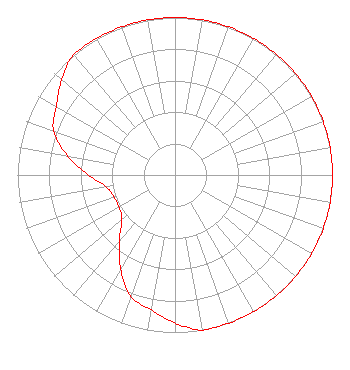 | ||||||||||||||||||
| Azimuth | Ratio | Azimuth | Ratio | Azimuth | Ratio | Azimuth | Ratio | ||||||||||||
| 0 | 1.000 | 10 | 1.000 | 20 | 1.000 | 30 | 1.000 | ||||||||||||
| 40 | 1.000 | 50 | 1.000 | 60 | 1.000 | 70 | 1.000 | ||||||||||||
| 80 | 1.000 | 90 | 1.000 | 100 | 1.000 | 110 | 1.000 | ||||||||||||
| 120 | 1.000 | 130 | 1.000 | 140 | 1.000 | 150 | 1.000 | ||||||||||||
| 160 | 1.000 | 170 | 1.000 | 180 | 0.940 | 190 | 0.870 | ||||||||||||
| 200 | 0.820 | 210 | 0.690 | 220 | 0.550 | 230 | 0.440 | ||||||||||||
| 240 | 0.410 | 250 | 0.410 | 260 | 0.440 | 270 | 0.550 | ||||||||||||
| 280 | 0.690 | 290 | 0.820 | 300 | 0.870 | 310 | 0.940 | ||||||||||||
| 320 | 1.000 | 330 | 1.000 | 340 | 1.000 | 350 | 1.000 | ||||||||||||
Structure Registration Number 1235884 Structure Type: TOWER Registered To: AMERICAN FAMILY ASSOCIATION Structure Address: 2 Miles Off Frontage Rd As I-40 Crosses 1-20 On Pollard, 1/2 Mile On Left Conroe, TX County Name: Montgomery County ASR Issued: 10/19/2009 Date Built: 05/30/2003 Site Elevation: 79.2 m (260 ft.) Structure Height: 152.4 m (500 ft.) Height Overall: 152.4 m (500 ft.) Overall Height AMSL: 231.6 m (760 ft.) FAA Determination: 08/16/2002 FAA Study #: 02-ASW-2789-OE FAA Circular #: 70/7460-1K Paint & Light FAA Chapters: 4, 6, 12 PRIOR STUDY 01-ASW-4610-OE 30-27-52.7 N 95-30-20.7 W (NAD 83) 30-27-52.0 N 95-30-19.9 W (Converted to NAD 27) |
Huntsville, TX 77342 Phone: 912-634-6575 Limited Liability Company | Date: 07/23/2018 Application Certifier HEH COMMUNICATIONS, LLC 205 Marina Drive St. Simons Island, GA 31522 Applicant CHARLES M. ANDERSON 1519 Euclid Avenue Bowling Green, KY 42103 ENGINEERING CONSULTANT SALLY A. BUCKMAN, ESQ. Lerman Senter Pllc 2001 L Street Nw Suite 400 Washington, DC 20036 | |||||||||||||||||