
FCCInfo.com
A Service of Cavell, Mertz & Associates, Inc.
(855) FCC-INFO
|
|
|
|
|
||||||||||||||||
|
|
K204DN Channel: 204D 88.7 MHz Paragould, Arkansas Service: FX - A translator or application for a translator. Facility ID: 92655 Fac. Service: FX Programming Delivery Method: Unspecified Status: License Application Accepted: 06/26/2014 Application Granted: 07/21/2014 File Number: BLFT-20140626AAR License Expires: 00/00/0000 Prefix Type: This is a license for a translator Application Type: License To Cover FCC Website Links: LMS Facility Details This Application CDBS Application Other K204DN Applications Other K204DN Applications in CDBS Including Superseded Applications Mailing Address Correspondence for K204DN Correspondence related to application BLFT-20140626AAR Service Contour - Open Street Map or USGS Map (60 dBu) Service Contour - KML / Google Earth (60 dBu) Class: D, A Noncommercial educational operating with no more than 10W Site Location: 36-04-06.2 N 90-37-58.4 W (NAD 83) Site Location: 36-04-06.0 N 90-37-58.0 W (Converted to NAD 27) Effective Radiated Power: 0 kW Horiz. ; 0.14 kW Vert. Transmitter Output Power: 0.196 kW Antenna Center HAAT: 122.1 m Horiz.; 0 m Vert. Antenna Center AMSL: 0 m Horiz.; 223 m Vert. Antenna Center HAG: 0 m Horiz.; 75 m Vert. Site Elevation: 148 m. (486 ft.) Height Overall*: 106 m (348 ft.) (* As Filed In This Application, may differ from ASR Data, Below.) Directional Antenna Antenna Make/Model: None Antenna ID: 31326 Polarization:
| ||||||||||||||||||
| Antenna Data for Antenna Id: 31326 K204DN FX File: BLFT-20140626AAR None - Service: FX Pattern and Field Values Include a 90° Clockwise Rotation | 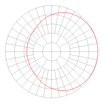 | ||||||||||||||||||
| Azimuth | Ratio | Azimuth | Ratio | Azimuth | Ratio | Azimuth | Ratio | ||||||||||||
| 0 | 0.792 | 10 | 0.845 | 20 | 0.892 | 30 | 0.929 | ||||||||||||
| 40 | 0.956 | 50 | 0.975 | 60 | 0.987 | 70 | 0.995 | ||||||||||||
| 80 | 0.999 | 90 | 1.000 | 100 | 0.999 | 110 | 0.995 | ||||||||||||
| 120 | 0.987 | 130 | 0.975 | 140 | 0.956 | 150 | 0.929 | ||||||||||||
| 160 | 0.892 | 170 | 0.845 | 180 | 0.792 | 190 | 0.735 | ||||||||||||
| 200 | 0.679 | 210 | 0.630 | 220 | 0.592 | 230 | 0.566 | ||||||||||||
| 240 | 0.549 | 250 | 0.540 | 260 | 0.535 | 270 | 0.534 | ||||||||||||
| 280 | 0.535 | 290 | 0.540 | 300 | 0.549 | 310 | 0.566 | ||||||||||||
| 320 | 0.592 | 330 | 0.630 | 340 | 0.679 | 350 | 0.735 | ||||||||||||
Structure Registration Number 1206727 [ASR Heights Differ from K204DN Application] Structure Type: TOWER Registered To: Nicki G Arnold dba Paragould Communications Structure Address: 333 Greene 712 Rd Paragould, AR County Name: Greene County ASR Issued: 11/30/1999 Date Built: 02/03/1995 Site Elevation: 147.5 m (484 ft.) Structure Height: 100.6 m (330 ft.) Height Overall: 106.4 m (349 ft.) Overall Height AMSL: 253.9 m (833 ft.) FAA Determination: 11/17/1999 FAA Study #: 99-ASW-3870-OE FAA Circular #: 70/7460-1J Paint & Light FAA Chapters: 4, 6, 13 Removed expiration date from determination. Scenario 1./jjs/case#635066 36-04-06.4 N 90-37-58.1 W (NAD 83) 36-04-06.2 N 90-37-57.7 W (Converted to NAD 27) |
4002 N. 3300 E. Twin Falls, ID 83301 Phone: 208-734-6633 Not-for-Profit | Date: 06/26/2014 Application Certifier CALVARY CHAPEL OF TWIN FALLS, INC. Po Box 391 Twin Falls, ID 83301 Applicant LOIS MILLS Po Box 391 Twin Falls, ID 83303 APPLICATION TECHNICIAN CARY TEPPER Tepper Law Firm, Llc 4900 Auburn Avenue, Suite 100 Bethesda, MD 20814-2632 | |||||||||||||||||