
FCCInfo.com
A Service of Cavell, Mertz & Associates, Inc.
(855) FCC-INFO
|
|
K256CR from 05/03/2013 |
|
|
||||||||||||||||
|
|
K256CR Channel: 256D 99.1 MHz Tulsa, Oklahoma Service: FX - A translator or application for a translator. Facility ID: 156338 Fac. Service: FX Programming Delivery Method: Unspecified Status: License Application Accepted: 03/30/2017 Application Granted: 04/05/2017 File Number: BLFT-20170330AAB License Expires: 00/00/0000 Prefix Type: This is a license for a translator Application Type: License To Cover FCC Website Links: LMS Facility Details This Application CDBS Application Other K256CR Applications Other K256CR Applications in CDBS Including Superseded Applications Mailing Address Correspondence for K256CR Correspondence related to application BLFT-20170330AAB Service Contour - Open Street Map or USGS Map (60 dBu) Service Contour - KML / Google Earth (60 dBu) Class: D, A Noncommercial educational operating with no more than 10W Site Location: 36-09-45.3 N 95-58-45.0 W (NAD 83) Site Location: 36-09-45.0 N 95-58-44.0 W (Converted to NAD 27) Effective Radiated Power: 0.25 kW Transmitter Output Power: 0.19 kW Antenna Center HAAT: 0 m Antenna Center AMSL: 354 m (1161 ft.) Antenna Center HAG: 134 m (440 ft.) Site Elevation: 220 m. (722 ft.) Height Overall*: 152 m (499 ft.) (* As Filed In This Application, may differ from ASR Data, Below.) Directional Antenna Antenna Make/Model: None Antenna ID: 125821 Polarization:
| ||||||||||||||||||
| Antenna Data for Antenna Id: 125821 K256CR FX File: BLFT-20170330AAB None - Service: FX | 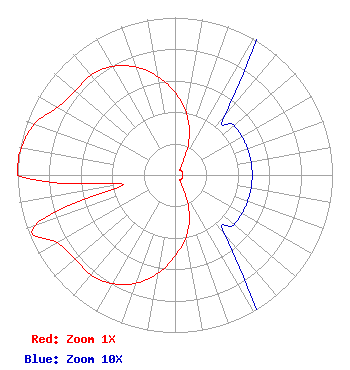 | ||||||||||||||||||
| Azimuth | Ratio | Azimuth | Ratio | Azimuth | Ratio | Azimuth | Ratio | ||||||||||||
| 0 | 0.524 | 10 | 0.403 | 20 | 0.267 | 30 | 0.113 | ||||||||||||
| 40 | 0.049 | 50 | 0.049 | 60 | 0.049 | 70 | 0.049 | ||||||||||||
| 80 | 0.049 | 90 | 0.049 | 100 | 0.049 | 110 | 0.049 | ||||||||||||
| 120 | 0.049 | 130 | 0.049 | 140 | 0.049 | 150 | 0.113 | ||||||||||||
| 160 | 0.267 | 170 | 0.403 | 180 | 0.514 | 190 | 0.636 | ||||||||||||
| 200 | 0.731 | 210 | 0.796 | 220 | 0.829 | 230 | 0.829 | ||||||||||||
| 240 | 0.860 | 250 | 0.949 | 260 | 0.330 | 270 | 1.000 | ||||||||||||
| 280 | 0.990 | 290 | 0.949 | 300 | 0.860 | 310 | 0.829 | ||||||||||||
| 320 | 0.829 | 330 | 0.796 | 340 | 0.731 | 350 | 0.636 | ||||||||||||
Structure Registration Number 1201785 Structure Type: LTOWER Registered To: American Towers LLC Structure Address: 1015 E. Archer St. North (373731) Tulsa, OK County Name: Tulsa County ASR Issued: 11/14/2023 Date Built: 12/27/2001 Site Elevation: 219.8 m (721 ft.) Structure Height: 144.8 m (475 ft.) Height Overall: 152.4 m (500 ft.) Overall Height AMSL: 372.2 m (1221 ft.) FAA Determination: 01/10/2023 FAA Study #: 2022-ASW-11729-OE FAA Circular #: 70/7460-1J Paint & Light FAA Chapters: 4, 8, 13 PRIOR STUDIES 2001-ASW-6957-OE / 2015-ASW-4938-OE 36-09-45.6 N 95-58-45.4 W (NAD 83) 36-09-45.3 N 95-58-44.4 W (Converted to NAD 27) |
1528 N.e. 23rd Oklahoma City, OK 73111 Phone: 405-425-4100 Corporation | Date: 03/30/2017 Application Certifier PERRY BROADCASTING OF LAWTON, INC. 1528 Ne 23rd Street Oklahoma City, OK 73111 Applicant CHARLES M. ANDERSON 1519 Euclid Avenue Bowling Green, KY 42103 CONSULTANT H. EDWARD DEBEE Debee Gilchrist 100 N. Broadway Avenue Suite 1500 Oklahoma City, OK 73102 | |||||||||||||||||