
FCCInfo.com
A Service of Cavell, Mertz & Associates, Inc.
(855) FCC-INFO
|
|
WTCB from 09/05/1986 WTCB from 04/15/1985 |
|  |
|
|||||||||||||||||||||
|
|
WTCB Channel: 294C1 106.7 MHz Orangeburg, South Carolina Service: FM - A full-service FM station or application. Facility ID: 54791 Fac. Service: FM Status: License Application Accepted: 12/03/1998 Application Granted: 03/19/1999 File Number: BMLH-19981203KA License Expires: 00/00/0000 Prefix Type: This is a modification of a license for a commecial FM station Application Type: Minor Modification FCC Website Links: LMS Facility Details This Application CDBS Application Other WTCB Applications Other WTCB Applications in CDBS Including Superseded Applications Mailing Address Correspondence for WTCB Correspondence related to application BMLH-19981203KA Service Contour - Open Street Map or USGS Map (60 dBu) Service Contour - KML / Google Earth (60 dBu) Public Inspection Files History Cards for WTCB Facility Type: FM STATION Class: C1, A Zone II station; with 50kW-100kW ERP and a class contour distance 52km-72km Site Location: 33-46-52.6 N 80-55-13.3 W (NAD 83) Site Location: 33-46-52.0 N 80-55-14.0 W (Converted to NAD 27) Effective Radiated Power: 100 kW Antenna Center HAAT: 240 m (787 ft.) Antenna Center AMSL: 304 m (997 ft.) Antenna Center HAG: 201 m (659 ft.) Calculated Site Elevation: 103 m. (338 ft.) Height Overall*: 217.6 m (714 ft.) (* As Filed In This Application, may differ from ASR Data, Below.) Directional Antenna Antenna Make/Model: Oddball; usually designed by Applicant ODD981203KA Antenna ID: 15777 Polarization: | ||||||||||||||||||||||||
| Antenna Data for Antenna Id: 15777 WTCB FM File: BMLH-19981203KA Oddball; usually designed by Applicant - ODD981203KA Service: FM | 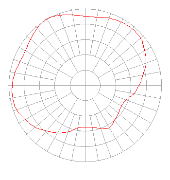 | ||||||||||||||||||||||||
| Azimuth | Ratio | Azimuth | Ratio | Azimuth | Ratio | Azimuth | Ratio | ||||||||||||||||||
| 0 | 0.900 | 10 | 0.900 | 20 | 0.930 | 30 | 0.950 | ||||||||||||||||||
| 40 | 0.960 | 50 | 0.950 | 60 | 0.900 | 70 | 0.850 | ||||||||||||||||||
| 80 | 0.770 | 90 | 0.710 | 100 | 0.650 | 110 | 0.570 | ||||||||||||||||||
| 120 | 0.550 | 130 | 0.570 | 140 | 0.600 | 150 | 0.640 | ||||||||||||||||||
| 160 | 0.600 | 170 | 0.560 | 180 | 0.550 | 190 | 0.570 | ||||||||||||||||||
| 200 | 0.650 | 210 | 0.720 | 220 | 0.780 | 230 | 0.850 | ||||||||||||||||||
| 240 | 0.900 | 250 | 0.950 | 260 | 0.960 | 270 | 0.950 | ||||||||||||||||||
| 280 | 0.930 | 290 | 0.900 | 300 | 0.900 | 310 | 0.930 | ||||||||||||||||||
| 320 | 0.970 | 330 | 1.000 | 340 | 0.970 | 350 | 0.930 | ||||||||||||||||||
Structure Registration Number 1045513 [ASR Heights Differ from WTCB Application] Structure Type: TOWER Registered To: VB Nimbus, LLC Structure Address: 0.5 M East Of Us Hwy 176, 11 M Northwest Of City St. Matthews, SC County Name: Calhoun County ASR Issued: 10/14/2020 Date Built: 01/01/1985 Site Elevation: 102.1 m (335 ft.) Structure Height: 216.7 m (711 ft.) Height Overall: 217.6 m (714 ft.) Overall Height AMSL: 319.7 m (1049 ft.) Paint & Light FAA Chapters: 1, 3, 5, 14, 21 33-46-53.0 N 80-55-13.0 W (NAD 83) 33-46-52.4 N 80-55-13.7 W (Converted to NAD 27) |
780 Johnson Ferry Road Suite 500 Atlanta, GA 30342 Phone: 404-949-0700 Limited Liability Company | Date: 12/03/1998 Application Certifier RADIO SOUTH CAROLINA, INC. Radio South Carolina, Inc. P.o. Box 5106 Columbia, SC 29250 Applicant | |||||||||||||||||||||||
|
| ||||||||||||||||||||||||