
FCCInfo.com
A Service of Cavell, Mertz & Associates, Inc.
(855) FCC-INFO
|
|
K208EK from 07/26/1999 K208EK from 12/04/1998 |
|
|
||||||||||||||||
|
|
K208EK Channel: 208D 89.5 MHz Parsons, Kansas Service: FX - A translator or application for a translator. Facility ID: 92264 Fac. Service: FX Programming Delivery Method: Unspecified Status: License Application Accepted: 05/05/2008 Application Granted: 06/17/2008 File Number: BLFT-20080505AAN License Expires: 00/00/0000 Prefix Type: This is a license for a translator Application Type: License To Cover FCC Website Links: LMS Facility Details This Application CDBS Application Other K208EK Applications Other K208EK Applications in CDBS Including Superseded Applications Mailing Address Correspondence for K208EK Correspondence related to application BLFT-20080505AAN Service Contour - Open Street Map or USGS Map (60 dBu) Service Contour - KML / Google Earth (60 dBu) Class: D, A Noncommercial educational operating with no more than 10W Site Location: 37-23-07.2 N 95-14-06.9 W (NAD 83) Site Location: 37-23-07.0 N 95-14-06.0 W (Converted to NAD 27) Effective Radiated Power: 0 kW Horiz. ; 0.19 kW Vert. Transmitter Output Power: 0.246 kW Antenna Center HAAT: 0 m Horiz.; 95 m Vert. Antenna Center AMSL: 0 m Horiz.; 369 m Vert. Antenna Center HAG: 0 m Horiz.; 87 m Vert. Site Elevation: 282 m. (925 ft.) Height Overall*: 131 m (430 ft.) (* As Filed In This Application, may differ from ASR Data, Below.) Directional Antenna Antenna Make/Model: None Antenna ID: 86096 Polarization:
| ||||||||||||||||||
| Antenna Data for Antenna Id: 86096 K208EK FX File: BLFT-20080505AAN None - Service: FX Pattern and Field Values Include a 220° Clockwise Rotation | 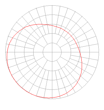 | ||||||||||||||||||
| Azimuth | Ratio | Azimuth | Ratio | Azimuth | Ratio | Azimuth | Ratio | ||||||||||||
| 0 | 0.566 | 10 | 0.549 | 20 | 0.540 | 30 | 0.535 | ||||||||||||
| 40 | 0.534 | 50 | 0.535 | 60 | 0.540 | 70 | 0.549 | ||||||||||||
| 80 | 0.566 | 90 | 0.592 | 100 | 0.630 | 110 | 0.679 | ||||||||||||
| 120 | 0.735 | 130 | 0.792 | 140 | 0.845 | 150 | 0.892 | ||||||||||||
| 160 | 0.929 | 170 | 0.956 | 180 | 0.975 | 190 | 0.987 | ||||||||||||
| 200 | 0.995 | 210 | 0.999 | 220 | 1.000 | 230 | 0.999 | ||||||||||||
| 240 | 0.995 | 250 | 0.987 | 260 | 0.975 | 270 | 0.956 | ||||||||||||
| 280 | 0.929 | 290 | 0.892 | 300 | 0.845 | 310 | 0.792 | ||||||||||||
| 320 | 0.735 | 330 | 0.679 | 340 | 0.630 | 350 | 0.592 | ||||||||||||
Structure Registration Number 1032208 Structure Type: TOWER Registered To: American Towers LLC Structure Address: 4.8 Km North Parsons, KS County Name: Neosho County ASR Issued: 12/09/2016 Date Built: 12/19/1994 Site Elevation: 281.6 m (924 ft.) Structure Height: 121.9 m (400 ft.) Height Overall: 130.7 m (429 ft.) Overall Height AMSL: 412.3 m (1353 ft.) FAA Determination: 09/27/2001 FAA Study #: 01-ACE-2236-OE Paint & Light FAA Chapters: A2, H, 3, 4, 13, 21, 23 Removed expiration date from determination. Scenario 1./jjs/case#635066 37-23-07.4 N 95-14-06.9 W (NAD 83) 37-23-07.2 N 95-14-06.0 W (Converted to NAD 27) |
4002 N. 3300 E. Twin Falls, ID 83301 Phone: 208-733-3133 Not-for-Profit | Date: 05/05/2008 Application Certifier CALVARY CHAPEL OF TWIN FALLS, INC. P.o. Box 391 Twin Falls, ID 83303 Applicant LOIS MILLS Po Box 391 Twin Falls, ID 83303 APPLICATIONS TECHNICIAN CARY TEPPER Booth, Freret, Imlay And Tepper, Pc 7900 Wisconsin Ave, Suite 304 Bethesda, MD 20814 | |||||||||||||||||