
FCCInfo.com
A Service of Cavell, Mertz & Associates, Inc.
(855) FCC-INFO
|
|
|
|
|
||||||||||||||||
|
|
WJHO Channel: 209C2 89.7 MHz Alexander City, Alabama Service: FM - A full-service FM station or application. Facility ID: 121797 Fac. Service: FM Status: License (Licensed And Silent) Application Accepted: 02/28/2014 Application Granted: 03/28/2014 File Number: BLED-20140228AGE License Expires: 00/00/0000 Prefix Type: This is a license for a noncommercial educational FM station Application Type: License To Cover FCC Website Links: LMS Facility Details This Application CDBS Application Other WJHO Applications Other WJHO Applications in CDBS Including Superseded Applications Mailing Address Correspondence for WJHO Correspondence related to application BLED-20140228AGE Service Contour - Open Street Map or USGS Map (60 dBu) Service Contour - KML / Google Earth (60 dBu) Public Inspection Files Facility Type: NON-COMMERCIAL EDUC. FM Class: C2, A Zone II station; with 25kW-50kW ERP and a class contour distance 39km-52km Site Location: 33-12-30.4 N 85-59-30.9 W (NAD 83) Site Location: 33-12-30.0 N 85-59-31.0 W (Converted to NAD 27) Effective Radiated Power: 0 kW Horiz. ; 21 kW Vert. Transmitter Output Power: 4.36 kW Antenna Center HAAT: 0 m Horiz.; 147 m Vert. Antenna Center AMSL: 0 m Horiz.; 438 m Vert. Antenna Center HAG: 0 m Horiz.; 102 m Vert. Calculated Site Elevation: m. Height Overall*: 107 m (351 ft.) (* As Filed In This Application, may differ from ASR Data, Below.) Directional Antenna Antenna Make/Model: Shivley 6025-2/2-1-DA, two sections Antenna ID: 113699 Polarization: | ||||||||||||||||||
| Antenna Data for Antenna Id: 113699 WJHO FM File: BLED-20140228AGE Shivley - 6025-2/2-1-DA, two sections Service: FM | 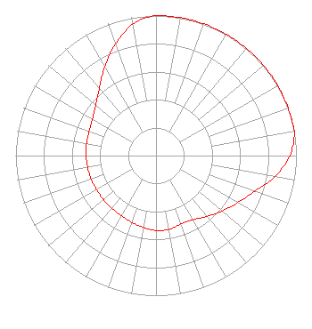 | ||||||||||||||||||
| Azimuth | Ratio | Azimuth | Ratio | Azimuth | Ratio | Azimuth | Ratio | ||||||||||||
| 0 | 1.000 | 10 | 1.000 | 20 | 1.000 | 30 | 1.000 | ||||||||||||
| 40 | 1.000 | 50 | 1.000 | 60 | 1.000 | 70 | 1.000 | ||||||||||||
| 80 | 1.000 | 90 | 0.953 | 100 | 0.859 | 110 | 0.747 | ||||||||||||
| 120 | 0.673 | 130 | 0.615 | 140 | 0.567 | 150 | 0.528 | ||||||||||||
| 160 | 0.520 | 170 | 0.535 | 180 | 0.535 | 190 | 0.521 | ||||||||||||
| 200 | 0.507 | 210 | 0.495 | 220 | 0.490 | 230 | 0.488 | ||||||||||||
| 240 | 0.488 | 250 | 0.491 | 260 | 0.494 | 270 | 0.498 | ||||||||||||
| 280 | 0.502 | 290 | 0.507 | 300 | 0.523 | 310 | 0.560 | ||||||||||||
| 320 | 0.627 | 330 | 0.732 | 340 | 0.847 | 350 | 0.953 | ||||||||||||
Structure Registration Number 1278941 [ASR Heights Differ from WJHO Application] Structure Type: TOWER Registered To: Radioland IV LLC Structure Address: 1750 Ft. Nnw Of Intersection Of Al Hwy 148 And Brian Rd, Clay Co Alabama Millerville, AL County Name: Clay County ASR Issued: 04/08/2024 Date Built: 08/19/2011 Site Elevation: 336 m (1102 ft.) Structure Height: 106 m (348 ft.) Height Overall: 107 m (351 ft.) Overall Height AMSL: 443 m (1453 ft.) FAA Determination: 05/10/2011 FAA Study #: 2011-ASO-2562-OE FAA Circular #: 70/7460-1K Paint & Light FAA Chapters: 4, 6, 12 33-12-30.3 N 85-59-31.2 W (NAD 83) 33-12-29.9 N 85-59-31.3 W (Converted to NAD 27) |
Po Box 91 Ashland, AL 36251 Phone: 256-252-1023 Not-for-Profit | Date: 02/28/2014 Application Certifier ALABAMA CHRISTIAN RADIO, INC. P.o. Box 2208 Auburn, AL 36831 Applicant ROBERT COKER Sterling Communications, Inc. 219 Dodd Road Ringgold, GA 30736 TECHNICAL CONSULTANT ROBERT COKER Sterling Communications, Inc. | |||||||||||||||||
| |||||||||||||||||||