|
WQHN Channel: 265C3 100.9 MHz
East Jordan, Michigan
Service: FM - A full-service FM station or application.
Facility ID: 28886
FRN: 0006703417
Fac. Service: FM
Status: LIC
73.215 Station
Application Accepted: 09/12/2019
Application Granted: 09/20/2019
File Number: BLED-20190912AAA
License Expires: 10/01/2028
Prefix Type: This is a license for a noncommercial educational FM station
Application Type: Amendment
FCC Website Links:
LMS Facility Details
This Application
Other WQHN Applications
Including Superseded Applications
Service Contour - Open Street Map or USGS Map (60 dBu)
Service Contour - KML / Google Earth (60 dBu)
Public Inspection Files
Facility Type: NON-COMMERCIAL EDUC. FM
Class: C3, A Zone II station; with 6kW-25kW ERP and a class contour distance 28km-39km
Site Location: 45-10-40.0 N 85-05-57.2 W (NAD 83)
Site Location: 45-10-40.0 N 85-05-57.0 W (Converted to NAD 27)
Effective Radiated Power: 11.5 kW
Transmitter Output Power: 4.864 kW
Antenna Center HAAT: 149 m (489 ft.)
Antenna Center AMSL: 375 m (1230 ft.)
Antenna Center HAG: 61 m (200 ft.)
Calculated Site Elevation: 314 m. (1030 ft.)
Height Overall*: 81 m (266 ft.)
(* As Filed In This Application, may differ from ASR Data, Below.)
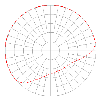
Directional Antenna
Antenna Make/Model: Propagation System Inc PSIFM-4C-DA, 4 sections
Antenna ID: 133774
Polarization:
|
Structure Information
Structure Registration Number 1004399
Structure Type: Registered To:
Northern Christian Radio
Structure Address:
On Dutchman Bay Rd 2.5 Km Ne
East Jordan, MI
County Name: Charlevoix County
ASR Issued: 07/04/2021
Date Built: 05/15/1989
Site Elevation: 314 m (1030 ft.)
Structure Height: 80.5 m (264 ft.)
Height Overall: 80.8 m (265 ft.)
Overall Height AMSL: 394.8 m (1295 ft.)
FAA Determination: 12/31/1987
FAA Study #: 87-AGL-1371-OE
FAA Circular #: 70/7460-1G
Paint & Light FAA Chapters: 3, 4, 5, 9
Removed final date from determination. Scenario 3./jjs/case#635066
45-10-40.0 N 85-05-57.0 W (NAD 83)
45-10-40.0 N 85-05-56.8 W
(Converted to NAD 27)
|
WQHN(FM) Licensee Information
Northern Christian Radio
P.O. Box 695
Gaylord, MI 49734
Phone: 989-732-6274
Private Not-for-Profit Educational Institution | 20190912AAA Applicant Information
Patrick Scott
Date: 09/12/2019
Application Certifier
Northern Christian Radio, Inc.
PO Box 695
Gaylord, MI 49734-0695
Applicant
Del Reynolds
PO Box 695
Gaylord, MI 49734
Station Engineer
Matthew H. McCormick
Fletcher, Heald & Hildreth, P.L.C.
|