
FCCInfo.com
A Service of Cavell, Mertz & Associates, Inc.
(855) FCC-INFO
|
|
|
|
|
||||||||||||||||
|
|
WRFL Channel: 201C3 88.1 MHz Lexington, Kentucky Service: FM - A full-service FM station or application. Facility ID: 54586 Fac. Service: FM Status: License Application Accepted: 06/04/2010 Application Granted: 06/16/2010 File Number: BLED-20100604AAR License Expires: 00/00/0000 Prefix Type: This is a license for a noncommercial educational FM station Application Type: License To Cover FCC Website Links: LMS Facility Details This Application CDBS Application Other WRFL Applications Other WRFL Applications in CDBS Including Superseded Applications Mailing Address Correspondence for WRFL Correspondence related to application BLED-20100604AAR Service Contour - Open Street Map or USGS Map (60 dBu) Service Contour - KML / Google Earth (60 dBu) Public Inspection Files Facility Type: NON-COMMERCIAL EDUC. FM Class: C3, A Zone II station; with 6kW-25kW ERP and a class contour distance 28km-39km Site Location: 38-02-19.3 N 84-30-15.8 W (NAD 83) Site Location: 38-02-19.0 N 84-30-16.0 W (Converted to NAD 27) Effective Radiated Power: 7.9 kW Transmitter Output Power: 1.631 kW Antenna Center HAAT: 87 m (285 ft.) Antenna Center AMSL: 374 m (1227 ft.) Antenna Center HAG: 77 m (253 ft.) Site Elevation: 297 m. (974 ft.) Height Overall*: 89 m (292 ft.) (* As Filed In This Application, may differ from ASR Data, Below.) Directional Antenna Antenna Make/Model: Electronics Research Inc. 1091-4CP-DA-HW, 4 bays, 0.5 wavelength spaced Antenna ID: 68840 Polarization: | ||||||||||||||||||
| Antenna Data for Antenna Id: 68840 WRFL FM File: BLED-20100604AAR Electronics Research Inc. - 1091-4CP-DA-HW, 4 bays, 0.5 wavelength spaced Service: FM | 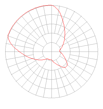 | ||||||||||||||||||
| Azimuth | Ratio | Azimuth | Ratio | Azimuth | Ratio | Azimuth | Ratio | ||||||||||||
| 0 | 1.000 | 10 | 0.890 | 20 | 0.708 | 30 | 0.563 | ||||||||||||
| 40 | 0.448 | 50 | 0.357 | 60 | 0.284 | 70 | 0.226 | ||||||||||||
| 80 | 0.180 | 90 | 0.178 | 100 | 0.223 | 110 | 0.280 | ||||||||||||
| 120 | 0.352 | 130 | 0.442 | 140 | 0.447 | 150 | 0.356 | ||||||||||||
| 160 | 0.283 | 170 | 0.225 | 180 | 0.179 | 190 | 0.178 | ||||||||||||
| 200 | 0.178 | 210 | 0.178 | 220 | 0.223 | 230 | 0.280 | ||||||||||||
| 240 | 0.352 | 250 | 0.442 | 260 | 0.555 | 270 | 0.697 | ||||||||||||
| 280 | 0.875 | 290 | 1.000 | 300 | 1.000 | 310 | 1.000 | ||||||||||||
| 320 | 1.000 | 330 | 1.000 | 340 | 1.000 | 350 | 1.000 | ||||||||||||
Structure Registration Number 1207223 [ASR Heights Differ from WRFL Application] Structure Type: BTWR Registered To: University of Kentucky Structure Address: Uk Campus, East Of Administration & Patterson Dr. Intersect. Lexington, KY County Name: Fayette County ASR Issued: 12/08/1999 Site Elevation: 298.4 m (979 ft.) Structure Height: 72.8 m (239 ft.) Height Overall: 88.7 m (291 ft.) Overall Height AMSL: 387.1 m (1270 ft.) FAA Determination: 08/02/1999 FAA Study #: 99-ASO-3085-OE FAA Circular #: 70/7460-1J Paint & Light FAA Chapters: 3, 4, 5, 13 38-02-18.8 N 84-30-15.7 W (NAD 83) 38-02-18.5 N 84-30-15.9 W (Converted to NAD 27) |
Wrfl 160 Avenue Of Champions, Suite 154 Lexington, KY 40506 Phone: 859-257-3273 Government Entity | Date: 06/04/2010 Application Certifier BOARD OF TRUSTEES, UNIVERSITY OF KENTUCKY 203 Student Center Lexington, KY 40506-0030 Applicant M SCOTT CASON Po Box 42 Lagrange, KY 40031 CONSULTING ENGINEER CHRISTOPHER PAUL THURINGER Christopher Paul Thuringer | |||||||||||||||||