
FCCInfo.com
A Service of Cavell, Mertz & Associates, Inc.
(855) FCC-INFO
|
|
WGZZ from 06/22/2004 WGZZ from 06/01/1989 |
|  |
|
|||||||||||||||
|
|
WGZZ Channel: 232A 94.3 MHz Waverly, Alabama Service: FM - A full-service FM station or application. Facility ID: 15283 Fac. Service: FM Analog & Digital Status: Construction Permit 73.215 Station Application Accepted: 07/20/2017 Application Pending: 07/21/2017 File Number: BPH-20170720AAN WGZZ CP Expires: 00/00/0000 Prefix Type: This is a construction permit for a commercial FM station Application Type: Minor Amendment FCC Website Links: LMS Facility Details This Application CDBS Application Other WGZZ Applications Other WGZZ Applications in CDBS Including Superseded Applications Mailing Address Correspondence for WGZZ Correspondence related to application BPH-20170720AAN Service Contour - Open Street Map or USGS Map (60 dBu) Service Contour - KML / Google Earth (60 dBu) Public Inspection Files Facility Type: FM STATION Class: A, A Zone I; I-A; or II station; with 0.1kW-6kW ERP and a class contour distance <=28km Site Location: 32-40-03.5 N 85-33-00.8 W (NAD 83) Site Location: 32-40-03.0 N 85-33-01.0 W (Converted to NAD 27) Effective Radiated Power: 2.6 kW Antenna Center HAAT: 154.6 m (507 ft.) Antenna Center AMSL: 352.1 m (1155 ft.) Antenna Center HAG: 129 m (423 ft.) Calculated Site Elevation: 223.1 m. (732 ft.) Height Overall*: 152.1 m (499 ft.) (* As Filed In This Application, may differ from ASR Data, Below.) Directional Antenna Antenna Make/Model: None Antenna ID: 134541 Polarization:
| ||||||||||||||||||
| Antenna Data for Antenna Id: 134541 WGZZ FM File: BPH-20170720AAN None - Service: FM | 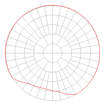 | ||||||||||||||||||
| Azimuth | Ratio | Azimuth | Ratio | Azimuth | Ratio | Azimuth | Ratio | ||||||||||||
| 0 | 1.000 | 10 | 1.000 | 20 | 1.000 | 30 | 1.000 | ||||||||||||
| 40 | 1.000 | 50 | 1.000 | 60 | 1.000 | 70 | 1.000 | ||||||||||||
| 80 | 1.000 | 90 | 1.000 | 100 | 1.000 | 110 | 1.000 | ||||||||||||
| 120 | 1.000 | 130 | 1.000 | 140 | 1.000 | 150 | 1.000 | ||||||||||||
| 160 | 0.920 | 170 | 0.830 | 180 | 0.790 | 190 | 0.770 | ||||||||||||
| 200 | 0.770 | 210 | 0.790 | 220 | 0.830 | 230 | 0.920 | ||||||||||||
| 240 | 1.000 | 250 | 1.000 | 260 | 1.000 | 270 | 1.000 | ||||||||||||
| 280 | 1.000 | 290 | 1.000 | 300 | 1.000 | 310 | 1.000 | ||||||||||||
| 320 | 1.000 | 330 | 1.000 | 340 | 1.000 | 350 | 1.000 | ||||||||||||
Structure Registration Number 1307550 Structure Type: GTOWER Registered To: Hubbard Properties LLC Structure Address: Farmville Road Auburn, AL County Name: Lee County ASR Issued: 11/06/2019 Date Built: 11/04/2019 Site Elevation: 223.1 m (732 ft.) Structure Height: 151 m (495 ft.) Height Overall: 152.1 m (499 ft.) Overall Height AMSL: 375.2 m (1231 ft.) FAA Determination: 07/17/2017 FAA Study #: 2017-ASO-12172-OE FAA Circular #: 70/7460-1L Paint & Light FAA Chapters: 3, 4, 5, 12 Removed expiration date from determination. Scenario 1./jjs/case#635066 32-40-04.0 N 85-33-00.8 W (NAD 83) 32-40-03.5 N 85-33-01.0 W (Converted to NAD 27) |
Auburn, AL 36831 Phone: 334-826-2929 Corporation | Date: 07/20/2017 Application Certifier AUBURN NETWORK, INC. P.o. Box 950 Auburn, AL 36831-0950 Applicant LEE REYNOLDS Post Office Box 383174 Birmingham, AL 35238 CONSULTING ENGINEER MARK LIPP Fletcher Heald & Hildreth Plc 1300 N. 17th Street Arlington, VA 22209 | |||||||||||||||||
| |||||||||||||||||||