
FCCInfo.com
A Service of Cavell, Mertz & Associates, Inc.
(855) FCC-INFO
|
|
K251BZ from 12/04/2013 |
|
|
||||||||||||||||
|
|
K251BZ Channel: 251D 98.1 MHz Branson, Missouri Service: FX - A translator or application for a translator. Facility ID: 140384 Fac. Service: FX Programming Delivery Method: Unspecified Status: License Application Accepted: 11/03/2016 Application Granted: 11/15/2016 File Number: BLFT-20161103ACF License Expires: 00/00/0000 Prefix Type: This is a license for a translator Application Type: License To Cover FCC Website Links: LMS Facility Details This Application CDBS Application Other K251BZ Applications Other K251BZ Applications in CDBS Including Superseded Applications Mailing Address Correspondence for K251BZ Correspondence related to application BLFT-20161103ACF Service Contour - Open Street Map or USGS Map (60 dBu) Service Contour - KML / Google Earth (60 dBu) Class: D, A Noncommercial educational operating with no more than 10W Site Location: 36-43-52.2 N 93-10-02.6 W (NAD 83) Site Location: 36-43-52.0 N 93-10-02.0 W (Converted to NAD 27) Effective Radiated Power: 0.25 kW Transmitter Output Power: 0.75 kW Antenna Center HAAT: 0 m Antenna Center AMSL: 472 m (1549 ft.) Antenna Center HAG: 94 m (308 ft.) Site Elevation: 378 m. (1240 ft.) Height Overall*: 137 m (449 ft.) (* As Filed In This Application, may differ from ASR Data, Below.) Directional Antenna Antenna Make/Model: None Antenna ID: 123158 Polarization:
| ||||||||||||||||||
| Antenna Data for Antenna Id: 123158 K251BZ FX File: BLFT-20161103ACF None - Service: FX Pattern and Field Values Include a 159° Clockwise Rotation | 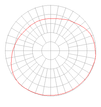 | ||||||||||||||||||
| Azimuth | Ratio | Azimuth | Ratio | Azimuth | Ratio | Azimuth | Ratio | ||||||||||||
| 9 | 0.712 | 19 | 0.732 | 29 | 0.772 | 39 | 0.802 | ||||||||||||
| 49 | 0.853 | 59 | 0.909 | 69 | 0.953 | 79 | 0.973 | ||||||||||||
| 89 | 0.983 | 99 | 1.000 | 109 | 0.992 | 119 | 0.988 | ||||||||||||
| 129 | 0.988 | 139 | 0.983 | 149 | 0.983 | 159 | 0.983 | ||||||||||||
| 169 | 0.983 | 179 | 0.983 | 189 | 0.988 | 199 | 0.988 | ||||||||||||
| 209 | 0.992 | 219 | 1.000 | 229 | 0.991 | 239 | 0.963 | ||||||||||||
| 249 | 0.923 | 259 | 0.873 | 269 | 0.832 | 279 | 0.792 | ||||||||||||
| 289 | 0.762 | 299 | 0.732 | 309 | 0.710 | 319 | 0.702 | ||||||||||||
| 329 | 0.702 | 339 | 0.702 | 349 | 0.702 | 359 | 0.702 | ||||||||||||
Structure Registration Number 1007047 Structure Type: GTOWER Registered To: Ozark Mountain Media Group, LLC Structure Address: 0.75 Km Ne Of Hwy 160-hwy 176 Junction & 3.5 Km North Of Rockaway Beach. Rockaway Beach, MO County Name: Taney County ASR Issued: 01/02/2019 Date Built: 08/29/1992 Site Elevation: 377.9 m (1240 ft.) Structure Height: 121.9 m (400 ft.) Height Overall: 137.2 m (450 ft.) Overall Height AMSL: 515.1 m (1690 ft.) FAA Determination: 08/18/2016 FAA Study #: 2016-ACE-3386-OE FAA Circular #: 70/7460-1H Paint & Light FAA Chapters: 4, 6, 13 OM&L to remain the same as prior study = 24-HR MED-STROBES 36-43-52.9 N 93-10-04.1 W (NAD 83) 36-43-52.7 N 93-10-03.5 W (Converted to NAD 27) |
47 Patterson Ave. Branson, MO 65616 Phone: 417-337-5400 Limited Liability Company | Date: 11/03/2016 Application Certifier KOMC-KRZK, LLC 202 Courtney Street Branson, MO 65616 Applicant GREGORY L BEST 16100 Outlook Avenue Stilwell, KS 66085 CONSULTING ENGINEER FRANK R. JAZZO, ESQUIRE Fletcher, Heald & Hildreth, P.l.c. 1300 N. 17th Street 11th Floor Arlington, VA 22209 | |||||||||||||||||