
FCCInfo.com
A Service of Cavell, Mertz & Associates, Inc.
(855) FCC-INFO
|
|
KRLE from 04/24/2006 KRLE from 10/15/1998 |
|
|
||||||||||||||||
|
|
KRLE Channel: 209C1 89.7 MHz Carbon Hill, Alabama Service: FM - A full-service FM station or application. Facility ID: 91901 Fac. Service: FM Status: License Application Accepted: 11/30/2012 Application Granted: 12/13/2012 File Number: BLED-20121130BEH License Expires: 00/00/0000 Prefix Type: This is a license for a noncommercial educational FM station Application Type: License To Cover FCC Website Links: LMS Facility Details This Application CDBS Application Other KRLE Applications Other KRLE Applications in CDBS Including Superseded Applications Mailing Address Correspondence for KRLE Correspondence related to application BLED-20121130BEH Service Contour - Open Street Map or USGS Map (60 dBu) Service Contour - KML / Google Earth (60 dBu) Public Inspection Files Facility Type: NON-COMMERCIAL EDUC. FM Class: C1, A Zone II station; with 50kW-100kW ERP and a class contour distance 52km-72km Site Location: 34-02-01.4 N 87-36-48.1 W (NAD 83) Site Location: 34-02-01.0 N 87-36-48.0 W (Converted to NAD 27) Effective Radiated Power: 0.001 kW Horiz. ; 79 kW Vert. Transmitter Output Power: 9.876 kW Antenna Center HAAT: 154 m (505 ft.) Antenna Center AMSL: 349 m (1145 ft.) Antenna Center HAG: 107 m (351 ft.) Calculated Site Elevation: 242 m. (794 ft.) Height Overall*: 130 m (427 ft.) (* As Filed In This Application, may differ from ASR Data, Below.) Directional Antenna Antenna Make/Model: Shivley 6510-4-SLANT(0.2)-DA, four sections Antenna ID: 110691 Polarization: | ||||||||||||||||||
| Antenna Data for Antenna Id: 110691 KRLE FM File: BLED-20121130BEH Shivley - 6510-4-SLANT(0.2)-DA, four sections Service: FM | 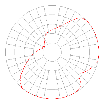 | ||||||||||||||||||
| Azimuth | Ratio | Azimuth | Ratio | Azimuth | Ratio | Azimuth | Ratio | ||||||||||||
| 0 | 0.479 | 10 | 0.520 | 20 | 0.598 | 30 | 0.753 | ||||||||||||
| 40 | 0.948 | 50 | 1.000 | 60 | 1.000 | 70 | 1.000 | ||||||||||||
| 80 | 1.000 | 90 | 1.000 | 100 | 1.000 | 110 | 0.926 | ||||||||||||
| 120 | 0.833 | 130 | 0.757 | 140 | 0.953 | 150 | 0.994 | ||||||||||||
| 160 | 1.000 | 170 | 1.000 | 180 | 1.000 | 190 | 1.000 | ||||||||||||
| 200 | 1.000 | 210 | 1.000 | 220 | 1.000 | 222 | 0.980 | ||||||||||||
| 223 | 0.969 | 224 | 0.958 | 226 | 0.947 | 228 | 0.914 | ||||||||||||
| 230 | 0.878 | 240 | 0.697 | 250 | 0.554 | 260 | 0.440 | ||||||||||||
| 270 | 0.350 | 280 | 0.278 | 290 | 0.221 | 300 | 0.222 | ||||||||||||
| 310 | 0.196 | 320 | 0.247 | 330 | 0.311 | 340 | 0.391 | ||||||||||||
| 350 | 0.437 | ||||||||||||||||||
Structure Registration Number 1284058 [ASR Heights Differ from KRLE Application] Structure Type: TOWER Registered To: VB-S1 Assets, LLC Structure Address: Natural Bridge A-9358 Lynn, AL County Name: Winston County ASR Issued: 02/06/2018 Date Built: 06/04/2012 Site Elevation: 242.3 m (795 ft.) Structure Height: 128 m (420 ft.) Height Overall: 129.5 m (425 ft.) Overall Height AMSL: 371.8 m (1220 ft.) FAA Determination: 12/22/2011 FAA Study #: 2011-ASO-7687-OE FAA Circular #: 70/7460-1K Paint & Light FAA Chapters: 4, 8, 12 Removed expiration date from determination. Scenario 1./jjs/case#635066 34-02-01.0 N 87-36-47.9 W (NAD 83) 34-02-00.6 N 87-36-47.8 W (Converted to NAD 27) |
5700 West Oaks Blvd Rocklin, CA 95765 Phone: 916-251-1600 Not-for-Profit | Date: 11/30/2012 Application Certifier EDUCATIONAL MEDIA FOUNDATION 5700 West Oaks Blvd Rocklin, CA 95765 Applicant SAM WALLINGTON 5700 West Oaks Blvd Rocklin, CA 95765 VP OF ENGINEERING DAVID OXENFORD, ESQ Wilkinson Barker Knauer, Llp | |||||||||||||||||