
FCCInfo.com
A Service of Cavell, Mertz & Associates, Inc.
(855) FCC-INFO
|
|
KDXE from 10/11/2009 KDXE from 02/14/2005 KDXE from 10/07/1994 KDXE from 10/04/1991 |
|  |
|
|||||||||||||||
|
|
KDXE Channel: 266A 101.1 MHz Cammack Village, Arkansas Service: FM - A full-service FM station or application. Facility ID: 49255 Fac. Service: FM Status: License 73.215 Station Application Accepted: 03/08/2010 Application Granted: 03/10/2010 File Number: BLH-20100308ABI License Expires: 00/00/0000 Prefix Type: This is a license for a commercial FM station Application Type: License To Cover FCC Website Links: LMS Facility Details This Application CDBS Application Other KDXE Applications Other KDXE Applications in CDBS Including Superseded Applications Mailing Address Correspondence for KDXE Correspondence related to application BLH-20100308ABI Service Contour - Open Street Map or USGS Map (60 dBu) Service Contour - KML / Google Earth (60 dBu) Public Inspection Files Facility Type: FM STATION Class: A, A Zone I; I-A; or II station; with 0.1kW-6kW ERP and a class contour distance <=28km Site Location: 34-47-56.3 N 92-29-44.6 W (NAD 83) Site Location: 34-47-56.0 N 92-29-44.0 W (Converted to NAD 27) Effective Radiated Power: 0.85 kW Transmitter Output Power: 0.7 kW Antenna Center HAAT: 267 m (876 ft.) Antenna Center AMSL: 394 m (1293 ft.) Antenna Center HAG: 73 m (240 ft.) Calculated Site Elevation: 321 m. (1053 ft.) Height Overall*: 308 m (1010 ft.) (* As Filed In This Application, may differ from ASR Data, Below.) Directional Antenna Antenna Make/Model: Shivley 6810-2R-SS-DA Antenna ID: 97613 Polarization:
| ||||||||||||||||||
| Antenna Data for Antenna Id: 97613 KDXE FM File: BLH-20100308ABI Shivley - 6810-2R-SS-DA Service: FM | 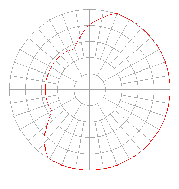 | ||||||||||||||||||
| Azimuth | Ratio | Azimuth | Ratio | Azimuth | Ratio | Azimuth | Ratio | ||||||||||||
| 0 | 0.800 | 10 | 0.900 | 20 | 1.000 | 30 | 1.000 | ||||||||||||
| 40 | 1.000 | 50 | 1.000 | 60 | 1.000 | 70 | 1.000 | ||||||||||||
| 80 | 1.000 | 90 | 1.000 | 100 | 1.000 | 110 | 1.000 | ||||||||||||
| 120 | 1.000 | 130 | 1.000 | 140 | 1.000 | 150 | 1.000 | ||||||||||||
| 160 | 1.000 | 170 | 1.000 | 180 | 1.000 | 190 | 1.000 | ||||||||||||
| 200 | 1.000 | 210 | 1.000 | 220 | 0.871 | 230 | 0.692 | ||||||||||||
| 240 | 0.550 | 250 | 0.550 | 260 | 0.550 | 270 | 0.550 | ||||||||||||
| 280 | 0.550 | 290 | 0.550 | 300 | 0.550 | 310 | 0.550 | ||||||||||||
| 320 | 0.550 | 330 | 0.550 | 340 | 0.550 | 350 | 0.660 | ||||||||||||
Structure Registration Number 1012584 Structure Type: TOWER Registered To: VB-S1 Assets, LLC Structure Address: 20324 Two Towers Rd Little Rock, AR County Name: Pulaski County ASR Issued: 04/01/2022 Date Built: 02/08/1988 Site Elevation: 320.9 m (1053 ft.) Structure Height: 308.4 m (1012 ft.) Height Overall: 308.4 m (1012 ft.) Overall Height AMSL: 629.3 m (2065 ft.) FAA Determination: 08/10/1987 FAA Study #: 87-ASW-0374-OE FAA Circular #: 70/7460-1G Paint & Light FAA Chapters: 4, 6, 9 34-47-56.0 N 92-29-45.0 W (NAD 83) 34-47-55.7 N 92-29-44.4 W (Converted to NAD 27) |
4880 Santa Rosa Road Camarillo, CA 93012 Phone: 805-987-0400 | Date: 03/08/2010 Application Certifier FLINN BROADCASTING CORPORATION 188 South Bellevue Suite 222 Memphis, TN 38104 Applicant CHARLES A. COOPER Du Treil, Lundin & Rackley, Inc. 201 Fletcher Avenue Sarasto, FL 34237 TECHNICAL CONSULTANT STEPHEN C. SIMPSON Attorney At Law | |||||||||||||||||