
FCCInfo.com
A Service of Cavell, Mertz & Associates, Inc.
(855) FCC-INFO
|
|
KDHT from 10/18/2006 KDHT from 05/23/2005 KDHT from 11/13/2000 KDHT from 12/28/1993 KDHT from 02/04/1991 KDHT from 06/15/1987 |
|
|
|||||||||||||||||||||||||
|
|
KDHT Channel: 239C0 95.7 MHz Denver, Colorado Service: FM - A full-service FM station or application. Facility ID: 48967 Fac. Service: FM Analog & Digital Status: License Application Accepted: 10/03/2007 Application Granted: 12/03/2007 File Number: BLH-20071003ACN License Expires: 00/00/0000 Prefix Type: This is a license for a commercial FM station Application Type: License To Cover FCC Website Links: LMS Facility Details This Application CDBS Application Other KDHT Applications Other KDHT Applications in CDBS Including Superseded Applications Mailing Address Correspondence for KDHT Correspondence related to application BLH-20071003ACN Service Contour - Open Street Map or USGS Map (60 dBu) Service Contour - KML / Google Earth (60 dBu) Public Inspection Files History Cards for KDHT Facility Type: FM STATION Class: C0, C0 Site Location: 39-43-59.0 N 105-14-12.0 W (NAD 83) Site Location: 39-43-59.0 N 105-14-10.0 W (Converted to NAD 27) Effective Radiated Power: 100 kW Transmitter Output Power: 15.8 kW Antenna Center HAAT: 346 m (1135 ft.) Antenna Center AMSL: 2256 m (7402 ft.) Antenna Center HAG: 49 m (161 ft.) Calculated Site Elevation: 2207 m. (7241 ft.) Height Overall*: 58 m (190 ft.) (* As Filed In This Application, may differ from ASR Data, Below.) Directional Antenna Antenna Make/Model: Electronics Research Inc. 1082-8CP-DA, 8 sections, 0.7 spacing Antenna ID: 76656 Polarization:
| |||||||||||||||||||||||||||
| Antenna Data for Antenna Id: 76656 KDHT FM File: BLH-20071003ACN Electronics Research Inc. - 1082-8CP-DA, 8 sections, 0.7 spacing Service: FM | 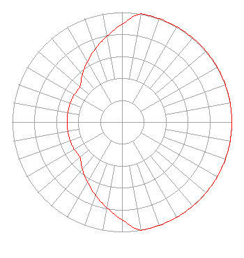 | |||||||||||||||||||||||||||
| Azimuth | Ratio | Azimuth | Ratio | Azimuth | Ratio | Azimuth | Ratio | |||||||||||||||||||||
| 0 | 0.891 | 10 | 1.000 | 20 | 1.000 | 30 | 1.000 | |||||||||||||||||||||
| 40 | 1.000 | 50 | 1.000 | 60 | 1.000 | 70 | 1.000 | |||||||||||||||||||||
| 80 | 1.000 | 90 | 1.000 | 100 | 1.000 | 110 | 1.000 | |||||||||||||||||||||
| 120 | 1.000 | 130 | 1.000 | 140 | 1.000 | 150 | 1.000 | |||||||||||||||||||||
| 160 | 1.000 | 170 | 1.000 | 180 | 0.891 | 190 | 0.794 | |||||||||||||||||||||
| 200 | 0.708 | 210 | 0.631 | 220 | 0.562 | 230 | 0.501 | |||||||||||||||||||||
| 240 | 0.501 | 250 | 0.501 | 260 | 0.501 | 270 | 0.501 | |||||||||||||||||||||
| 280 | 0.501 | 290 | 0.501 | 300 | 0.501 | 310 | 0.501 | |||||||||||||||||||||
| 320 | 0.562 | 330 | 0.631 | 340 | 0.708 | 350 | 0.794 | |||||||||||||||||||||
Structure Registration Number 1033691 Structure Type: TOWER Registered To: Vertical Bridge CC FM, LLC Structure Address: Lookout Mountain Golden, CO County Name: Jefferson County ASR Issued: 11/08/2018 Date Built: 03/11/1986 Site Elevation: 2206.8 m (7240 ft.) Structure Height: 58.4 m (192 ft.) Height Overall: 58.4 m (192 ft.) Overall Height AMSL: 2265.2 m (7432 ft.) FAA Determination: 09/19/1997 FAA Study #: 97-ANM-1008-OE Paint & Light FAA Chapters: NONE 39-43-59.0 N 105-14-12.0 W (NAD 83) 39-43-59.0 N 105-14-10.0 W (Converted to NAD 27) |
7136 S. Yale Avenue Suite 501 Tulsa, OK 74136 Phone: 918-664-4581 | Date: 10/03/2007 Application Certifier CITICASTERS LICENSES, L.P. 2625 S. Memorial Drive, Suite A Tulsa, OK 74129 Applicant LANCE NELMS 2625 S. Memorial Drive Suite A Tulsa, OK 74129 FCC ENGINEER MARISSA G. REPP Hogan & Hartson Llp | ||||||||||||||||||||||||||
| ||||||||||||||||||||||||||||