
FCCInfo.com
A Service of Cavell, Mertz & Associates, Inc.
(855) FCC-INFO
|
|
WKCH from 09/01/1993 WKCH from 05/28/1993 |
|  |
|
|||||||||||||||
|
|
WKCH Channel: 293A 106.5 MHz Whitewater, Wisconsin Service: FM - A full-service FM station or application. Facility ID: 59406 Fac. Service: FM Status: License 73.215 Station Application Accepted: 10/25/2006 Application Granted: 12/18/2006 File Number: BLH-20061025ABF License Expires: 00/00/0000 Prefix Type: This is a license for a commercial FM station Application Type: License To Cover FCC Website Links: LMS Facility Details This Application CDBS Application Other WKCH Applications Other WKCH Applications in CDBS Including Superseded Applications Mailing Address Correspondence for WKCH Correspondence related to application BLH-20061025ABF Service Contour - Open Street Map or USGS Map (60 dBu) Service Contour - KML / Google Earth (60 dBu) Public Inspection Files Facility Type: FM STATION Class: A, A Zone I; I-A; or II station; with 0.1kW-6kW ERP and a class contour distance <=28km Site Location: 42-54-20.0 N 88-45-05.4 W (NAD 83) Site Location: 42-54-20.0 N 88-45-05.0 W (Converted to NAD 27) Effective Radiated Power: 6 kW Transmitter Output Power: 2.6 kW Antenna Center HAAT: 61 m (200 ft.) Antenna Center AMSL: 317 m (1040 ft.) Antenna Center HAG: 76 m (249 ft.) Calculated Site Elevation: 241 m. (791 ft.) Height Overall*: 81 m (266 ft.) (* As Filed In This Application, may differ from ASR Data, Below.) Directional Antenna Antenna Make/Model: Systems With Reliability Inc. FM3/3-DA Antenna ID: 59088 Polarization: | ||||||||||||||||||
| Antenna Data for Antenna Id: 59088 WKCH FM File: BLH-20061025ABF Systems With Reliability Inc. - FM3/3-DA Service: FM | 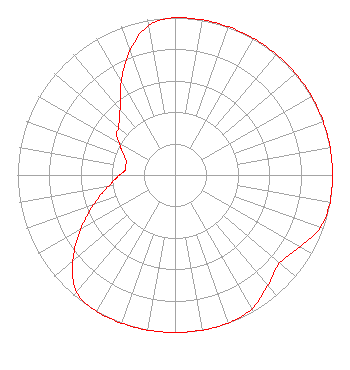 | ||||||||||||||||||
| Azimuth | Ratio | Azimuth | Ratio | Azimuth | Ratio | Azimuth | Ratio | ||||||||||||
| 0 | 1.000 | 10 | 1.000 | 20 | 1.000 | 30 | 1.000 | ||||||||||||
| 40 | 1.000 | 50 | 1.000 | 60 | 1.000 | 70 | 1.000 | ||||||||||||
| 80 | 1.000 | 90 | 1.000 | 100 | 1.000 | 110 | 0.980 | ||||||||||||
| 120 | 0.915 | 130 | 0.869 | 140 | 0.916 | 150 | 0.979 | ||||||||||||
| 160 | 1.000 | 170 | 1.000 | 180 | 1.000 | 190 | 1.000 | ||||||||||||
| 200 | 1.000 | 210 | 1.000 | 220 | 0.971 | 230 | 0.846 | ||||||||||||
| 240 | 0.692 | 250 | 0.549 | 260 | 0.436 | 265 | 0.389 | ||||||||||||
| 270 | 0.353 | 275 | 0.320 | 280 | 0.320 | 285 | 0.320 | ||||||||||||
| 290 | 0.341 | 295 | 0.374 | 300 | 0.408 | 305 | 0.456 | ||||||||||||
| 310 | 0.469 | 320 | 0.543 | 330 | 0.684 | 340 | 0.839 | ||||||||||||
| 350 | 0.965 | ||||||||||||||||||
Structure Registration Number 1035465 Structure Type: 5TA5 Registered To: Magnum Communications, Inc Structure Address: Twr 5 W4362 Findlay Rd Cold Spring Township, WI County Name: Jefferson County ASR Issued: 09/09/2020 Date Built: 10/01/1997 Site Elevation: 240.8 m (790 ft.) Structure Height: 80.8 m (265 ft.) Height Overall: 80.8 m (265 ft.) Overall Height AMSL: 321.6 m (1055 ft.) FAA Determination: 10/21/1987 FAA Study #: 86-AGL-2356-OE Paint & Light FAA Chapters: None 42-54-20.0 N 88-45-05.0 W (NAD 83) 42-54-20.0 N 88-45-04.6 W (Converted to NAD 27) |
P.o. Box 118 West Bend, WI 53095 Phone: 262-334-2344 | Date: 10/25/2006 Application Certifier NRG LICENSE SUB, LLC 2875 Mt. Vernon Road Se Cedar Rapids, IA 52403 Applicant GEORGE NICHOLAS 2875 Mt. Vernon Road Se Cedar Rapids, IA 52403 DIRECTOR OF ENGINEERING DAVID D. BURNS Latham & Watkins Llp | |||||||||||||||||
| |||||||||||||||||||