
FCCInfo.com
A Service of Cavell, Mertz & Associates, Inc.
(855) FCC-INFO
|
|
WROQ from 09/24/1982 WROQ from 09/26/1980 |
|
|
||||||||||||||||
|
|
WROQ Channel: 266C1 101.1 MHz Anderson, South Carolina Service: FM - A full-service FM station or application. Facility ID: 318 Fac. Service: FM Status: License Application Accepted: 08/17/2018 Application Granted: 08/28/2018 File Number: BLH-20180817AAD License Expires: 00/00/0000 Prefix Type: This is a license for a commercial FM station Application Type: License To Cover FCC Website Links: LMS Facility Details This Application CDBS Application Other WROQ Applications Other WROQ Applications in CDBS Including Superseded Applications Mailing Address Correspondence for WROQ Correspondence related to application BLH-20180817AAD Service Contour - Open Street Map or USGS Map (60 dBu) Service Contour - KML / Google Earth (60 dBu) Public Inspection Files History Cards for WROQ Facility Type: FM STATION Class: C1, A Zone II station; with 50kW-100kW ERP and a class contour distance 52km-72km Site Location: 34-38-51.4 N 82-16-12.4 W (NAD 83) Site Location: 34-38-51.0 N 82-16-13.0 W (Converted to NAD 27) Effective Radiated Power: 100 kW Transmitter Output Power: 37.3 kW Antenna Center HAAT: 269 m (883 ft.) Antenna Center AMSL: 513.3 m (1684 ft.) Antenna Center HAG: 270 m (886 ft.) Calculated Site Elevation: 243.3 m. (798 ft.) Height Overall*: 320.3 m (1051 ft.) (* As Filed In This Application, may differ from ASR Data, Below.) Directional Antenna Antenna Make/Model: Electronics Research Inc. 1183-4CP-DA, four sections Antenna ID: 133463 Polarization:
| ||||||||||||||||||
| Antenna Data for Antenna Id: 133463 WROQ FM File: BLH-20180817AAD Electronics Research Inc. - 1183-4CP-DA, four sections Service: FM | 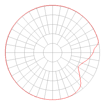 | ||||||||||||||||||
| Azimuth | Ratio | Azimuth | Ratio | Azimuth | Ratio | Azimuth | Ratio | ||||||||||||
| 0 | 1.000 | 10 | 1.000 | 20 | 1.000 | 30 | 1.000 | ||||||||||||
| 40 | 1.000 | 50 | 1.000 | 60 | 1.000 | 70 | 1.000 | ||||||||||||
| 75 | 1.000 | 80 | 0.970 | 85 | 0.890 | 90 | 0.860 | ||||||||||||
| 100 | 0.770 | 110 | 0.670 | 120 | 0.630 | 130 | 0.750 | ||||||||||||
| 140 | 0.920 | 150 | 0.980 | 160 | 1.000 | 170 | 1.000 | ||||||||||||
| 180 | 1.000 | 190 | 1.000 | 200 | 1.000 | 210 | 1.000 | ||||||||||||
| 220 | 1.000 | 230 | 1.000 | 240 | 1.000 | 250 | 1.000 | ||||||||||||
| 260 | 1.000 | 270 | 1.000 | 280 | 1.000 | 290 | 1.000 | ||||||||||||
| 300 | 1.000 | 310 | 1.000 | 320 | 1.000 | 330 | 1.000 | ||||||||||||
| 340 | 1.000 | 350 | 1.000 | ||||||||||||||||
Structure Registration Number 1045371 Structure Type: TOWER Registered To: CHESAPEAKE TELEVISION, INC Structure Address: Woodside Rd, 0.7 Mi W Off Airview Forkshoals, SC County Name: Greenville County ASR Issued: 04/23/1998 Date Built: 01/01/1983 Site Elevation: 243.3 m (798 ft.) Structure Height: 304.5 m (999 ft.) Height Overall: 320.3 m (1051 ft.) Overall Height AMSL: 563.6 m (1849 ft.) FAA Determination: 12/13/1983 FAA Study #: 83-ASO-166-OE Paint & Light FAA Chapters: 1, 3, 8, 17, 21 RED LIGHTS/PAINT 34-38-51.0 N 82-16-12.0 W (NAD 83) 34-38-50.6 N 82-16-12.6 W (Converted to NAD 27) |
2400 Market Street 4th Floor Philadelphia, PA 19103 Phone: 610-660-5610 Limited Liability Company | Date: 08/17/2018 Application Certifier ENTERCOM LICENSE, LLC 401 E. City Avenue Suite 809 Bala Cynwyd, PA 19004 Applicant LAURA M. MIZRAHI Communications Technologies, Inc. P. O. Box 1130 Marlton, NJ 08053 TECHNICAL CONSULTANT LAURA M. BERMAN Entercom Communications Corp. | |||||||||||||||||
| |||||||||||||||||||