
FCCInfo.com
A Service of Cavell, Mertz & Associates, Inc.
(855) FCC-INFO
|
|
|
|
|
||||||||||||||||
|
|
WLRN-FM Channel: 217C1 91.3 MHz Miami, Florida Service: FM - A full-service FM station or application. Facility ID: 66339 Fac. Service: FM Analog & Digital Status: License Application Accepted: 04/11/2003 Application Granted: 02/02/2006 File Number: BLED-20030411ABJ License Expires: 00/00/0000 Prefix Type: This is a license for a noncommercial educational FM station Application Type: Amendment FCC Website Links: LMS Facility Details This Application CDBS Application Other WLRN-FM Applications Other WLRN-FM Applications in CDBS Including Superseded Applications Mailing Address Correspondence for WLRN-FM Correspondence related to application BLED-20030411ABJ Service Contour - Open Street Map or USGS Map (60 dBu) Service Contour - KML / Google Earth (60 dBu) Public Inspection Files History Cards for WLRN-FM Facility Type: NON-COMMERCIAL EDUC. FM Class: C1, A Zone II station; with 50kW-100kW ERP and a class contour distance 52km-72km Site Location: 25-58-47.3 N 80-11-45.2 W (NAD 83) Site Location: 25-58-46.0 N 80-11-46.0 W (Converted to NAD 27) Effective Radiated Power: 47 kW Transmitter Output Power: 7.716 kW Antenna Center HAAT: 285 m (935 ft.) Antenna Center AMSL: 286.7 m (941 ft.) Antenna Center HAG: 284 m (932 ft.) Site Elevation: 2.7 m. (9 ft.) Height Overall*: 308 m (1010 ft.) (* As Filed In This Application, may differ from ASR Data, Below.) Directional Antenna Antenna Make/Model: None TCI DCBR-P2-6FM/12H-2, 6 section Antenna ID: 42024 Polarization:
| ||||||||||||||||||
| Antenna Data for Antenna Id: 42024 WLRN-FM FM File: BLED-20030411ABJ None - TCI DCBR-P2-6FM/12H-2, 6 section Service: FM | 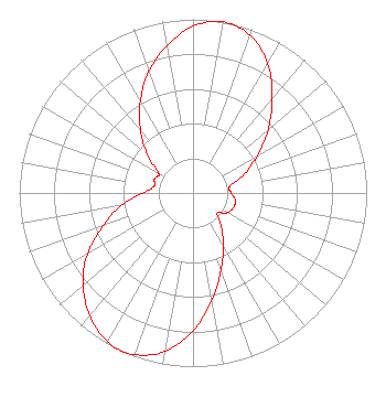 | ||||||||||||||||||
| Azimuth | Ratio | Azimuth | Ratio | Azimuth | Ratio | Azimuth | Ratio | ||||||||||||
| 0 | 0.960 | 10 | 1.000 | 20 | 0.966 | 30 | 0.862 | ||||||||||||
| 40 | 0.708 | 50 | 0.564 | 60 | 0.427 | 70 | 0.317 | ||||||||||||
| 80 | 0.214 | 90 | 0.220 | 100 | 0.248 | 110 | 0.248 | ||||||||||||
| 120 | 0.227 | 130 | 0.182 | 140 | 0.251 | 150 | 0.352 | ||||||||||||
| 160 | 0.472 | 170 | 0.625 | 180 | 0.793 | 190 | 0.925 | ||||||||||||
| 200 | 0.991 | 205 | 0.999 | 210 | 0.988 | 220 | 0.923 | ||||||||||||
| 230 | 0.826 | 240 | 0.703 | 250 | 0.549 | 260 | 0.421 | ||||||||||||
| 270 | 0.287 | 280 | 0.227 | 290 | 0.236 | 300 | 0.228 | ||||||||||||
| 310 | 0.343 | 320 | 0.469 | 330 | 0.608 | 340 | 0.744 | ||||||||||||
| 350 | 0.863 | ||||||||||||||||||
Structure Registration Number 1041402 Structure Type: TOWER Registered To: The School Board of Miami-Dade County, Florida Structure Address: 3300 Sw 52nd Ave Pembroke Park, FL County Name: Broward County ASR Issued: 12/17/2015 Date Built: 10/17/2002 Site Elevation: 3 m (10 ft.) Structure Height: 296 m (971 ft.) Height Overall: 308 m (1010 ft.) Overall Height AMSL: 311 m (1020 ft.) FAA Determination: 12/16/1997 FAA Study #: 97-ASO-1831-OE FAA Circular #: 70/7460-1K Paint & Light FAA Chapters: 4, 9, 12 25-58-47.0 N 80-11-45.0 W (NAD 83) 25-58-45.7 N 80-11-45.8 W (Converted to NAD 27) |
172 Northeast 15th Street Miami, FL 33132-1348 Government Entity | Date: 04/11/2003 Application Certifier THE SCHOOL BOARD OF MIAMI-DADE COUNTY, FLORIDA 172 Northeast 15th Street Miami, FL 33132 Applicant RYAN WILHOUR Kessler And Gehman Associates, Inc. 507 Nw 60th Street, Suite C Gainesville, FL 32607 CONSULTING ENGINEER JOSEPH A. BELISLE Leibowitz & Associates | |||||||||||||||||
| |||||||||||||||||||