
FCCInfo.com
A Service of Cavell, Mertz & Associates, Inc.
(855) FCC-INFO
|
|
K258DC from 01/22/2014 |
|
|
||||||||||||||||
|
|
K258DC Channel: 258D 99.5 MHz Omaha, Nebraska Service: FX - A translator or application for a translator. Facility ID: 156462 Fac. Service: FX Programming Delivery Method: Unspecified Status: License Application Accepted: 03/06/2017 Application Granted: 03/22/2017 File Number: BLFT-20170306AIV License Expires: 00/00/0000 Prefix Type: This is a license for a translator Application Type: License To Cover FCC Website Links: LMS Facility Details This Application CDBS Application Other K258DC Applications Other K258DC Applications in CDBS Including Superseded Applications Mailing Address Correspondence for K258DC Correspondence related to application BLFT-20170306AIV Service Contour - Open Street Map or USGS Map (60 dBu) Service Contour - KML / Google Earth (60 dBu) Class: D, A Noncommercial educational operating with no more than 10W Site Location: 41-13-29.6 N 95-57-11.6 W (NAD 83) Site Location: 41-13-29.6 N 95-57-10.5 W (Converted to NAD 27) Effective Radiated Power: 0.25 kW Transmitter Output Power: 0.095 kW Antenna Center HAAT: 0 m Antenna Center AMSL: 461 m (1512 ft.) Antenna Center HAG: 98 m (322 ft.) Site Elevation: 363 m. (1191 ft.) Height Overall*: 131 m (430 ft.) (* As Filed In This Application, may differ from ASR Data, Below.) Directional Antenna Antenna Make/Model: None Antenna ID: 125545 Polarization:
| ||||||||||||||||||
| Antenna Data for Antenna Id: 125545 K258DC FX File: BLFT-20170306AIV None - Service: FX Pattern and Field Values Include a 160° Clockwise Rotation | 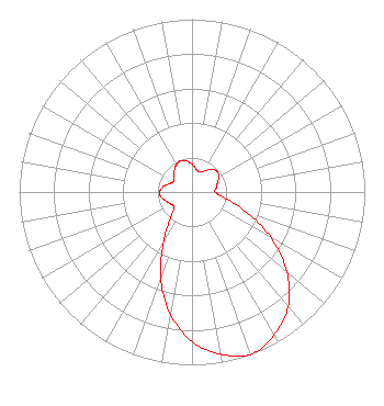 | ||||||||||||||||||
| Azimuth | Ratio | Azimuth | Ratio | Azimuth | Ratio | Azimuth | Ratio | ||||||||||||
| 0 | 0.160 | 10 | 0.135 | 20 | 0.123 | 30 | 0.140 | ||||||||||||
| 40 | 0.171 | 50 | 0.187 | 60 | 0.181 | 70 | 0.157 | ||||||||||||
| 80 | 0.142 | 90 | 0.134 | 100 | 0.190 | 110 | 0.329 | ||||||||||||
| 120 | 0.528 | 130 | 0.718 | 140 | 0.866 | 150 | 0.952 | ||||||||||||
| 160 | 1.000 | 170 | 0.952 | 180 | 0.866 | 190 | 0.718 | ||||||||||||
| 200 | 0.528 | 210 | 0.329 | 220 | 0.190 | 230 | 0.134 | ||||||||||||
| 240 | 0.142 | 250 | 0.157 | 260 | 0.181 | 270 | 0.187 | ||||||||||||
| 280 | 0.171 | 290 | 0.140 | 300 | 0.123 | 310 | 0.135 | ||||||||||||
| 320 | 0.160 | 330 | 0.182 | 340 | 0.193 | 350 | 0.182 | ||||||||||||
Structure Registration Number 1223431 Structure Type: TOWER Registered To: Global Tower, LLC. through American Towers, LLC Structure Address: 2808 "b" Street Omaha, NE County Name: Douglas County ASR Issued: 09/02/2014 Date Built: 03/14/2001 Site Elevation: 363 m (1191 ft.) Structure Height: 121.9 m (400 ft.) Height Overall: 131 m (430 ft.) Overall Height AMSL: 494 m (1621 ft.) FAA Determination: 10/05/2001 FAA Study #: 01-ACE-2153-OE FAA Circular #: 70/7460-1K Paint & Light FAA Chapters: 4, 8, 12 PRIOR STUDY 00-ACE-0423-OE 41-13-29.6 N 95-57-11.6 W (NAD 83) 41-13-29.6 N 95-57-10.5 W (Converted to NAD 27) |
2875 Mt. Vernon Rd. Se Cedar Rapids, IA 52403 Phone: 319-200-1900 Limited Liability Company | Date: 03/06/2017 Application Certifier NRG LICENSE SUB, LLC 2875 Mt. Vernon Road Se Cedar Rapids, IA 52403-3553 Applicant GEORGE NICHOLAS 2875 Mt. Vernon Road Se Cedar Rapids, IA 52403-3553 DIRECTOR OF ENGINEERING JOHN M. BURGETT Wiley Rein Llp 1776 K Street, Nw Washington, DC 20006 | |||||||||||||||||