
FCCInfo.com
A Service of Cavell, Mertz & Associates, Inc.
(855) FCC-INFO
|
|
|
|
|
||||||||||||||||
|
|
K252CV Channel: 252D 98.3 MHz Hobbs, New Mexico Service: FX - A translator or application for a translator. Facility ID: 16824 Fac. Service: FX Programming Delivery Method: Unspecified Status: License Application Accepted: 04/26/2016 Application Granted: 05/09/2016 File Number: BLFT-20160426AAT License Expires: 00/00/0000 Prefix Type: This is a license for a translator Application Type: License To Cover FCC Website Links: LMS Facility Details This Application CDBS Application Other K252CV Applications Other K252CV Applications in CDBS Including Superseded Applications Mailing Address Correspondence for K252CV Correspondence related to application BLFT-20160426AAT Service Contour - Open Street Map or USGS Map (60 dBu) Service Contour - KML / Google Earth (60 dBu) Class: D, A Noncommercial educational operating with no more than 10W Site Location: 32-40-03.0 N 103-07-27.0 W (NAD 83) Site Location: 32-40-02.6 N 103-07-25.3 W (Converted to NAD 27) Effective Radiated Power: 0.25 kW Horiz. ; 0 kW Vert. Transmitter Output Power: 0.075 kW Antenna Center HAAT: 107.2 m Horiz.; 0 m Vert. Antenna Center AMSL: 1199 m Horiz.; 0 m Vert. Antenna Center HAG: 100 m Horiz.; 0 m Vert. Site Elevation: 1099 m. (3606 ft.) Height Overall*: 140 m (459 ft.) (* As Filed In This Application, may differ from ASR Data, Below.) Directional Antenna Antenna Make/Model: None Antenna ID: 124637 Polarization:
| ||||||||||||||||||
| Antenna Data for Antenna Id: 124637 K252CV FX File: BLFT-20160426AAT None - Service: FX Pattern and Field Values Include a 215° Clockwise Rotation | 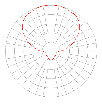 | ||||||||||||||||||
| Azimuth | Ratio | Azimuth | Ratio | Azimuth | Ratio | Azimuth | Ratio | ||||||||||||
| 5 | 1.000 | 15 | 0.992 | 25 | 0.957 | 35 | 0.940 | ||||||||||||
| 45 | 0.866 | 55 | 0.747 | 65 | 0.591 | 75 | 0.427 | ||||||||||||
| 85 | 0.282 | 95 | 0.150 | 105 | 0.114 | 115 | 0.118 | ||||||||||||
| 125 | 0.134 | 135 | 0.136 | 145 | 0.132 | 155 | 0.154 | ||||||||||||
| 165 | 0.175 | 175 | 0.191 | 185 | 0.191 | 195 | 0.175 | ||||||||||||
| 205 | 0.154 | 215 | 0.132 | 225 | 0.136 | 235 | 0.134 | ||||||||||||
| 245 | 0.118 | 255 | 0.114 | 265 | 0.150 | 275 | 0.282 | ||||||||||||
| 285 | 0.427 | 295 | 0.591 | 305 | 0.747 | 315 | 0.866 | ||||||||||||
| 325 | 0.940 | 335 | 0.957 | 345 | 0.992 | 355 | 1.000 | ||||||||||||
Structure Registration Number 1002830 [ASR Heights Differ from K252CV Application] Structure Type: GTOWER Registered To: American Towers LLC Structure Address: 3028 South Eunice Highway Hobbs, NM County Name: Lea County ASR Issued: 01/05/2021 Date Built: 01/01/1967 Site Elevation: 1100 m (3609 ft.) Structure Height: 134.1 m (440 ft.) Height Overall: 134.4 m (441 ft.) Overall Height AMSL: 1234.4 m (4050 ft.) FAA Determination: 06/14/2013 FAA Study #: 2013-ASW-2509-OE Paint & Light FAA Chapters: 1, 3, 12, 21 Continue As Is OM&L = PAINT/RED LIGHTS 32-40-00.3 N 103-07-34.2 W (NAD 83) 32-39-59.9 N 103-07-32.5 W (Converted to NAD 27) |
5511 Angus Road Odessa, TX 79764 Phone: 432-238-6384 | Date: 04/26/2016 Application Certifier JIMMY MICHAEL PICKETT P.o. Box 454 Elmore City, OK 73433 Applicant DAVID STEWART 9660 Audelia Suite 83-333 Dallas, TX 75238 CONSULTANT BARRY A. FRIEDMAN Thompson Hine Llp Suite 700 1919 M Street, N.w. Washington, DC 20036 | |||||||||||||||||