
FCCInfo.com
A Service of Cavell, Mertz & Associates, Inc.
(855) FCC-INFO
|
|
KNON from 04/25/1984 |
|  |
|
|||||||||||||||
|
|
KNON Channel: 207C1 89.3 MHz Dallas, Texas Service: FM - A full-service FM station or application. Facility ID: 601 Fac. Service: FM Analog & Digital Status: License Application Accepted: 03/09/1990 Application Granted: 10/19/1990 File Number: BLED-19900309KA License Expires: 08/01/1997 Prefix Type: This is a license for a noncommercial educational FM station Application Type: License To Cover FCC Website Links: LMS Facility Details This Application CDBS Application Other KNON Applications Other KNON Applications in CDBS Including Superseded Applications Mailing Address Correspondence for KNON Correspondence related to application BLED-19900309KA Service Contour - Open Street Map or USGS Map (60 dBu) Service Contour - KML / Google Earth (60 dBu) Public Inspection Files History Cards for KNON Facility Type: NON-COMMERCIAL EDUC. FM Class: C1, A Zone II station; with 50kW-100kW ERP and a class contour distance 52km-72km Site Location: 32-35-24.5 N 96-58-22.0 W (NAD 83) Site Location: 32-35-24.0 N 96-58-21.0 W (Converted to NAD 27) Effective Radiated Power: 55 kW Antenna Center HAAT: 259 m (850 ft.) Antenna Center AMSL: 449 m (1473 ft.) Antenna Center HAG: 193 m (633 ft.) Calculated Site Elevation: 256 m. (840 ft.) Height Overall*: 315 m (1033 ft.) (* As Filed In This Application, may differ from ASR Data, Below.) Directional Antenna Antenna Make/Model: Oddball; usually designed by Applicant ODD880120MR Antenna ID: 13835 Polarization: | ||||||||||||||||||
| Antenna Data for Antenna Id: 13835 KNON FM File: BLED-19900309KA Oddball; usually designed by Applicant - ODD880120MR Service: FM | 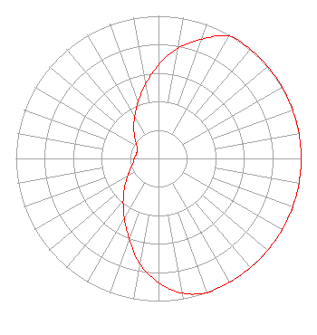 | ||||||||||||||||||
| Azimuth | Ratio | Azimuth | Ratio | Azimuth | Ratio | Azimuth | Ratio | ||||||||||||
| 0 | 0.655 | 10 | 0.785 | 20 | 0.890 | 30 | 0.990 | ||||||||||||
| 40 | 1.000 | 50 | 1.000 | 60 | 1.000 | 70 | 1.000 | ||||||||||||
| 80 | 1.000 | 90 | 1.000 | 100 | 1.000 | 110 | 1.000 | ||||||||||||
| 120 | 1.000 | 130 | 1.000 | 140 | 1.000 | 150 | 1.000 | ||||||||||||
| 160 | 1.000 | 170 | 0.960 | 180 | 0.870 | 190 | 0.750 | ||||||||||||
| 200 | 0.600 | 210 | 0.480 | 220 | 0.385 | 230 | 0.310 | ||||||||||||
| 240 | 0.250 | 250 | 0.210 | 260 | 0.180 | 270 | 0.170 | ||||||||||||
| 280 | 0.160 | 290 | 0.158 | 300 | 0.175 | 310 | 0.215 | ||||||||||||
| 320 | 0.270 | 330 | 0.335 | 340 | 0.420 | 350 | 0.525 | ||||||||||||
Structure Registration Number 1053994 [ASR Heights Differ from KNON Application] Structure Type: TOWER Registered To: Sonsinger Broadcasting Company of Houston, L.P. Structure Address: 1450 W Beltline Rd Cedar Hill, TX County Name: Dallas County ASR Issued: 01/03/2008 Date Built: 10/01/1985 Site Elevation: 252.8 m (829 ft.) Structure Height: 299.8 m (984 ft.) Height Overall: 325.2 m (1067 ft.) Overall Height AMSL: 578 m (1896 ft.) FAA Determination: 12/24/2007 FAA Study #: 2007-ASW-7814-OE FAA Circular #: 70/7460-1K Paint & Light FAA Chapters: 4, 5, 12 PRIOR STUDY 1998-ASW-2155-OE 32-35-25.0 N 96-58-24.0 W (NAD 83) 32-35-24.5 N 96-58-23.0 W (Converted to NAD 27) |
13154 Coit Road # 200 Dallas, TX 75240 Phone: 214-828-9500 Not-for-Profit | Date: 03/09/1990 Application Certifier AGAPE BROADCASTING FOUNDATION, INC. Agape Broadcasting Foundation, Inc. 4415 San Jacinto Dallas, TX 75204 Applicant | |||||||||||||||||