
FCCInfo.com
A Service of Cavell, Mertz & Associates, Inc.
(855) FCC-INFO
|
|
WYFY from 02/23/2011 WYFY from 09/14/2010 |
|  |
|
|||||||||||||||
|
|
WYFY Channel: 201A 88.1 MHz Cambridge, Ohio Service: FM - A full-service FM station or application. Facility ID: 172915 Fac. Service: FM Status: License Application Accepted: 06/07/2012 Application Granted: 10/22/2012 File Number: BLED-20120607ABS License Expires: 00/00/0000 Prefix Type: This is a license for a noncommercial educational FM station Application Type: License To Cover FCC Website Links: LMS Facility Details This Application CDBS Application Other WYFY Applications Other WYFY Applications in CDBS Including Superseded Applications Mailing Address Correspondence for WYFY Correspondence related to application BLED-20120607ABS Service Contour - Open Street Map or USGS Map (60 dBu) Service Contour - KML / Google Earth (60 dBu) Public Inspection Files Facility Type: NON-COMMERCIAL EDUC. FM Class: A, A Zone I; I-A; or II station; with 0.1kW-6kW ERP and a class contour distance <=28km Site Location: 40-01-37.3 N 81-33-08.4 W (NAD 83) Site Location: 40-01-37.0 N 81-33-09.0 W (Converted to NAD 27) Effective Radiated Power: 1.5 kW Transmitter Output Power: 1.008 kW Antenna Center HAAT: 44 m (144 ft.) Antenna Center AMSL: 327 m (1073 ft.) Antenna Center HAG: 61 m (200 ft.) Calculated Site Elevation: 266 m. (873 ft.) Height Overall*: 71 m (233 ft.) (* As Filed In This Application, may differ from ASR Data, Below.) Directional Antenna Antenna Make/Model: Systems With Reliability Inc. FMECR/2-PLUS-DA, two sections Antenna ID: 106331 Polarization:
| ||||||||||||||||||
| Antenna Data for Antenna Id: 106331 WYFY FM File: BLED-20120607ABS Systems With Reliability Inc. - FMECR/2-PLUS-DA, two sections Service: FM | 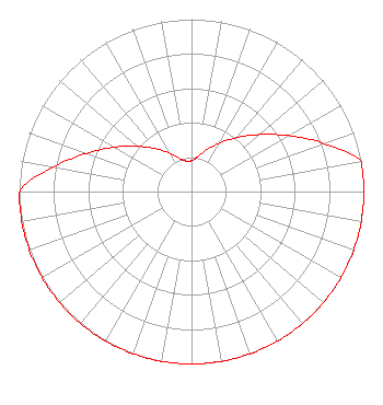 | ||||||||||||||||||
| Azimuth | Ratio | Azimuth | Ratio | Azimuth | Ratio | Azimuth | Ratio | ||||||||||||
| 0 | 0.179 | 10 | 0.205 | 20 | 0.258 | 30 | 0.325 | ||||||||||||
| 40 | 0.409 | 50 | 0.515 | 60 | 0.649 | 70 | 0.816 | ||||||||||||
| 80 | 1.000 | 90 | 1.000 | 100 | 1.000 | 110 | 1.000 | ||||||||||||
| 120 | 1.000 | 130 | 1.000 | 140 | 1.000 | 150 | 1.000 | ||||||||||||
| 160 | 1.000 | 170 | 1.000 | 180 | 1.000 | 190 | 1.000 | ||||||||||||
| 200 | 1.000 | 210 | 1.000 | 220 | 1.000 | 230 | 1.000 | ||||||||||||
| 240 | 1.000 | 250 | 1.000 | 260 | 1.000 | 270 | 1.000 | ||||||||||||
| 280 | 0.816 | 290 | 0.649 | 300 | 0.515 | 310 | 0.409 | ||||||||||||
| 320 | 0.325 | 330 | 0.258 | 340 | 0.205 | 350 | 0.179 | ||||||||||||
Structure Registration Number 1228355 Structure Type: TOWER Registered To: The Hafley Living Trust Structure Address: .72 Kilometers East Of Intersection Interstate 77 And Us Route 40 Cambridge, OH County Name: Guernsey County ASR Issued: 09/29/2021 Date Built: 11/01/2001 Site Elevation: 266.1 m (873 ft.) Structure Height: 70.4 m (231 ft.) Height Overall: 71 m (233 ft.) Overall Height AMSL: 337.1 m (1106 ft.) FAA Determination: 07/24/2001 FAA Study #: 01-AGL-3168-OE FAA Circular #: 70/7460-1K Paint & Light FAA Chapters: 4, 8, 12 PRIOR STUDY 98-AGL-965-OE 40-01-37.3 N 81-33-08.5 W (NAD 83) 40-01-37.0 N 81-33-09.1 W (Converted to NAD 27) |
11530 Carmel Commons Blvd. Charlotte, NC 28226 Phone: 704-523-5555 Not-for-Profit | Date: 06/07/2012 Application Certifier BIBLE BROADCASTING NETWORK, INC. 11530 Carmel Commons Blvd. Charlotte, NC 28226 Applicant JUSTIN W. ASHER Munn-reese, Inc. Po Box 220, 385 Airport Dr. Coldwater, MI 49036-0220 CONSULTING ENGINEER GARY S. SMITHWICK, ESQ. Smithwick & Belendiuk, P.c. | |||||||||||||||||