
FCCInfo.com
A Service of Cavell, Mertz & Associates, Inc.
(855) FCC-INFO
|
|
|
|  |
|
|||||||||||||||
|
|
WTBK Channel: 289C3 105.7 MHz Manchester, Kentucky Service: FM - A full-service FM station or application. Facility ID: 39774 Fac. Service: FM Status: License 73.215 Station Application Accepted: 04/05/2005 Application Granted: 05/02/2005 File Number: BLH-20050405ABK License Expires: 00/00/0000 Prefix Type: This is a license for a commercial FM station Application Type: License To Cover FCC Website Links: LMS Facility Details This Application CDBS Application Other WTBK Applications Other WTBK Applications in CDBS Including Superseded Applications Mailing Address Correspondence for WTBK Correspondence related to application BLH-20050405ABK Service Contour - Open Street Map or USGS Map (60 dBu) Service Contour - KML / Google Earth (60 dBu) Public Inspection Files Facility Type: FM STATION Class: C3, A Zone II station; with 6kW-25kW ERP and a class contour distance 28km-39km Site Location: 37-08-59.3 N 83-45-07.7 W (NAD 83) Site Location: 37-08-59.0 N 83-45-08.0 W (Converted to NAD 27) Effective Radiated Power: 5 kW Transmitter Output Power: 2.66 kW Antenna Center HAAT: 218 m (715 ft.) Antenna Center AMSL: 564 m (1850 ft.) Antenna Center HAG: 107 m (351 ft.) Calculated Site Elevation: 457 m. (1499 ft.) Height Overall*: 122 m (400 ft.) (* As Filed In This Application, may differ from ASR Data, Below.) Directional Antenna Antenna Make/Model: Propagation System Inc PSIFM-3-DA, three sections Antenna ID: 60151 Polarization: | ||||||||||||||||||
| Antenna Data for Antenna Id: 60151 WTBK FM File: BLH-20050405ABK Propagation System Inc - PSIFM-3-DA, three sections Service: FM | 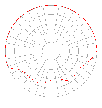 | ||||||||||||||||||
| Azimuth | Ratio | Azimuth | Ratio | Azimuth | Ratio | Azimuth | Ratio | ||||||||||||
| 0 | 1.000 | 10 | 1.000 | 20 | 1.000 | 30 | 1.000 | ||||||||||||
| 40 | 1.000 | 50 | 1.000 | 60 | 1.000 | 70 | 1.000 | ||||||||||||
| 80 | 1.000 | 90 | 1.000 | 100 | 0.900 | 110 | 0.810 | ||||||||||||
| 120 | 0.735 | 130 | 0.735 | 140 | 0.735 | 150 | 0.736 | ||||||||||||
| 160 | 0.656 | 170 | 0.610 | 180 | 0.636 | 190 | 0.697 | ||||||||||||
| 200 | 0.737 | 210 | 0.738 | 220 | 0.738 | 230 | 0.738 | ||||||||||||
| 240 | 0.810 | 250 | 1.000 | 260 | 1.000 | 270 | 1.000 | ||||||||||||
| 280 | 1.000 | 290 | 1.000 | 300 | 1.000 | 310 | 1.000 | ||||||||||||
| 320 | 1.000 | 330 | 1.000 | 340 | 1.000 | 350 | 1.000 | ||||||||||||
Structure Registration Number 1057447 Structure Type: TOWER Registered To: HOUSE, LAURA S Structure Address: On E Hill Manchester, KY County Name: Clay County ASR Issued: 10/21/1998 Date Built: 09/01/1957 Site Elevation: 457 m (1499 ft.) Structure Height: 121 m (397 ft.) Height Overall: 122 m (400 ft.) Overall Height AMSL: 579 m (1900 ft.) FAA Determination: 09/10/1998 FAA Study #: 98-ASO-5550-OE FAA Circular #: 70/7460-1J Paint & Light FAA Chapters: 3, 4, 5, 13 37-08-59.0 N 83-45-08.0 W (NAD 83) 37-08-58.7 N 83-45-08.3 W (Converted to NAD 27) |
100 N. Lasalle Street Suite 1111 Chicago, IL 60602 Phone: 312-345-1111 | Date: 04/05/2005 Application Certifier MANCHESTER COMMUNICATIONS, INC. P.o. Box 453 Manchester, KY 40962 Applicant TIM FINLEY P.o. Box 453 Manchester, KY 40962 PRESIDENT JOHN NEELY, ESQ. Miller And Neely, P.c. | |||||||||||||||||
| |||||||||||||||||||