
FCCInfo.com
A Service of Cavell, Mertz & Associates, Inc.
(855) FCC-INFO
|
|
|
|
|
||||||||||||||||
|
|
K274CG Channel: 274D 102.7 MHz Sonora, California Service: FX - A translator or application for a translator. Facility ID: 140902 Fac. Service: FX Programming Delivery Method: Unspecified Status: License Application Accepted: 12/02/2016 Application Granted: 12/22/2016 File Number: BLFT-20161202ABQ License Expires: 00/00/0000 Prefix Type: This is a license for a translator Application Type: License To Cover FCC Website Links: LMS Facility Details This Application CDBS Application Other K274CG Applications Other K274CG Applications in CDBS Including Superseded Applications Mailing Address Correspondence for K274CG Correspondence related to application BLFT-20161202ABQ Service Contour - Open Street Map or USGS Map (60 dBu) Service Contour - KML / Google Earth (60 dBu) Class: D, A Noncommercial educational operating with no more than 10W Site Location: 38-00-29.7 N 120-21-47.7 W (NAD 83) Site Location: 38-00-30.0 N 120-21-44.0 W (Converted to NAD 27) Effective Radiated Power: 0.25 kW Transmitter Output Power: 0.291 kW Antenna Center HAAT: 0 m Antenna Center AMSL: 1049 m (3442 ft.) Antenna Center HAG: 31 m (102 ft.) Site Elevation: 1018 m. (3340 ft.) Height Overall*: 55 m (180 ft.) (* As Filed In This Application, may differ from ASR Data, Below.) Directional Antenna Antenna Make/Model: None Antenna ID: 125798 Polarization:
| ||||||||||||||||||
| Antenna Data for Antenna Id: 125798 K274CG FX File: BLFT-20161202ABQ None - Service: FX | 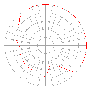 | ||||||||||||||||||
| Azimuth | Ratio | Azimuth | Ratio | Azimuth | Ratio | Azimuth | Ratio | ||||||||||||
| 0 | 1.000 | 10 | 1.000 | 20 | 1.000 | 30 | 1.000 | ||||||||||||
| 40 | 1.000 | 50 | 1.000 | 60 | 1.000 | 70 | 1.000 | ||||||||||||
| 80 | 1.000 | 90 | 1.000 | 100 | 1.000 | 110 | 1.000 | ||||||||||||
| 120 | 1.000 | 130 | 1.000 | 140 | 0.750 | 150 | 0.582 | ||||||||||||
| 160 | 0.537 | 170 | 0.537 | 180 | 0.750 | 190 | 0.692 | ||||||||||||
| 200 | 0.653 | 210 | 0.676 | 220 | 0.684 | 230 | 0.676 | ||||||||||||
| 240 | 0.653 | 250 | 0.653 | 260 | 0.653 | 270 | 0.638 | ||||||||||||
| 280 | 0.724 | 290 | 0.776 | 300 | 0.822 | 310 | 0.841 | ||||||||||||
| 320 | 0.944 | 330 | 0.944 | 340 | 1.000 | 350 | 1.000 | ||||||||||||
Structure Registration Number 1205700 Structure Type: TOWER Registered To: Clarke Broadcasting Corporation Structure Address: Top Of Bald Mountain, 1.9 Miles @ 37 Degrees True Sonora, CA County Name: Tuolumne County ASR Issued: 10/18/2005 Date Built: 01/01/1994 Site Elevation: 1018 m (3340 ft.) Structure Height: 54.9 m (180 ft.) Height Overall: 54.9 m (180 ft.) Overall Height AMSL: 1072.9 m (3520 ft.) FAA Determination: 10/13/2005 FAA Study #: 2005-AWP-4989-OE Paint & Light FAA Chapters: NONE Removed expiration date from determination. Scenario 1./jjs/case#635066 38-00-30.0 N 120-21-47.9 W (NAD 83) 38-00-30.3 N 120-21-44.2 W (Converted to NAD 27) |
120 Country Club Drive Suite 12 Incline Village, NV 89451 Phone: 775-831-1215 Corporation | Date: 12/02/2016 Application Certifier CLARKE BROADCASTING CORPORATION 120 Country Club Drive Suite 12 Incline Village, NV 89451 Applicant JOSEPH M. DAVIS, P.E. Chesapeake Rf Consultants, Llc 207 Old Dominion Road Yorktown, VA 23692 CONSULTING ENGINEER MEREDITH S. SENTER, JR. Lerman Senter Pllc 2001 L Street, Nw, Suite 400 Washington, DC 20036 | |||||||||||||||||