
FCCInfo.com
A Service of Cavell, Mertz & Associates, Inc.
(855) FCC-INFO
|
|
W249CK from 03/16/2004 |
|
|
||||||||||||||||
|
|
W249CK Channel: 249D 97.7 MHz Duluth, Georgia Service: FX - A translator or application for a translator. Facility ID: 147419 Fac. Service: FX Programming Delivery Method: Unspecified Status: License Application Accepted: 10/23/2014 Application Granted: 11/10/2014 File Number: BLFT-20141023ABI License Expires: 00/00/0000 Prefix Type: This is a license for a translator Application Type: License To Cover FCC Website Links: LMS Facility Details This Application CDBS Application Other W249CK Applications Other W249CK Applications in CDBS Including Superseded Applications Mailing Address Correspondence for W249CK Correspondence related to application BLFT-20141023ABI Service Contour - Open Street Map or USGS Map (60 dBu) Service Contour - KML / Google Earth (60 dBu) Class: D, A Noncommercial educational operating with no more than 10W Site Location: 34-07-32.4 N 83-51-31.6 W (NAD 83) Site Location: 34-07-32.0 N 83-51-32.0 W (Converted to NAD 27) Effective Radiated Power: 0.075 kW Horiz. ; 0 kW Vert. Transmitter Output Power: 0.786 kW Antenna Center HAAT: 0 m Antenna Center AMSL: 726 m Horiz.; 0 m Vert. Antenna Center HAG: 455 m Horiz.; 0 m Vert. Site Elevation: 271 m. (889 ft.) Height Overall*: 538 m (1765 ft.) (* As Filed In This Application, may differ from ASR Data, Below.) Directional Antenna Antenna Make/Model: None Antenna ID: 16150 Polarization:
| ||||||||||||||||||
| Antenna Data for Antenna Id: 16150 W249CK FX File: BLFT-20141023ABI None - Service: FX Pattern and Field Values Include a 260° Clockwise Rotation | 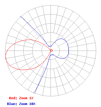 | ||||||||||||||||||
| Azimuth | Ratio | Azimuth | Ratio | Azimuth | Ratio | Azimuth | Ratio | ||||||||||||
| 0 | 0.010 | 10 | 0.010 | 20 | 0.015 | 30 | 0.025 | ||||||||||||
| 40 | 0.034 | 50 | 0.038 | 60 | 0.040 | 70 | 0.040 | ||||||||||||
| 80 | 0.040 | 90 | 0.040 | 100 | 0.040 | 110 | 0.038 | ||||||||||||
| 120 | 0.034 | 130 | 0.025 | 140 | 0.015 | 150 | 0.010 | ||||||||||||
| 160 | 0.010 | 170 | 0.010 | 180 | 0.010 | 190 | 0.020 | ||||||||||||
| 200 | 0.085 | 210 | 0.250 | 220 | 0.470 | 230 | 0.645 | ||||||||||||
| 240 | 0.820 | 250 | 0.950 | 260 | 1.000 | 270 | 0.950 | ||||||||||||
| 280 | 0.820 | 290 | 0.645 | 300 | 0.470 | 310 | 0.250 | ||||||||||||
| 320 | 0.085 | 330 | 0.020 | 340 | 0.010 | 350 | 0.010 | ||||||||||||
Structure Registration Number 1019528 Structure Type: TOWER Registered To: American Towers LLC Structure Address: 5510 Union Church Rd Flowery Branch, GA County Name: Hall County ASR Issued: 01/05/2021 Date Built: 08/17/1984 Site Elevation: 271.2 m (890 ft.) Structure Height: 515.1 m (1690 ft.) Height Overall: 537.9 m (1765 ft.) Overall Height AMSL: 809.1 m (2655 ft.) FAA Determination: 04/03/1997 FAA Study #: 97-ASO-0794-OE FAA Circular #: 70/7460-1J Paint & Light FAA Chapters: 4, 7, 13 34-07-32.0 N 83-51-32.0 W (NAD 83) 34-07-31.6 N 83-51-32.4 W (Converted to NAD 27) |
1601 W Peachtree Street Ne Atlanta, GA 30309 Phone: 404-897-7000 Limited Liability Company | Date: 10/23/2014 Application Certifier COX RADIO, INC. 1601 W. Peachtree Street, Ne Atlanta, GA 30309 Applicant CHARLES KINNEY 1601 West Peachtree Street, N.e. Atlanta, GA 30309 DIRECTOR OF ENGINEERING JOHN S. LOGAN Cooley Llp 1299 Pennsylvania Avenue, Nw Suite 700 Washington, DC 20004 | |||||||||||||||||