
FCCInfo.com
A Service of Cavell, Mertz & Associates, Inc.
(855) FCC-INFO
|
|
KYWA from 12/20/1996 KYWA from 05/22/1992 KYWA from 02/04/1991 KYWA from 11/10/1988 |
|  |
|
|||||||||||||||
|
|
KYWA Channel: 214C1 90.7 MHz Wichita, Kansas Service: FM - A full-service FM station or application. Facility ID: 48537 Fac. Service: FM Status: License Application Accepted: 02/16/2016 Application Granted: 04/13/2016 File Number: BMLED-20160216ABK License Expires: 00/00/0000 Prefix Type: This is a modification of license for a noncommercial educational FM station Application Type: Minor Modification FCC Website Links: LMS Facility Details This Application CDBS Application Other KYWA Applications Other KYWA Applications in CDBS Including Superseded Applications Mailing Address Correspondence for KYWA Correspondence related to application BMLED-20160216ABK Service Contour - Open Street Map or USGS Map (60 dBu) Service Contour - KML / Google Earth (60 dBu) Public Inspection Files Facility Type: NON-COMMERCIAL EDUC. FM Class: C1, A Zone II station; with 50kW-100kW ERP and a class contour distance 52km-72km Site Location: 37-28-37.1 N 97-04-29.1 W (NAD 83) Site Location: 37-28-37.0 N 97-04-28.0 W (Converted to NAD 27) Effective Radiated Power: 53 kW Horiz. ; 51.1 kW Vert. Transmitter Output Power: 9.92 kW Antenna Center HAAT: 144 m (472 ft.) Antenna Center AMSL: 520 m (1706 ft.) Antenna Center HAG: 142 m (466 ft.) Calculated Site Elevation: 378 m. (1240 ft.) Height Overall*: 149 m (489 ft.) (* As Filed In This Application, may differ from ASR Data, Below.) Directional Antenna Antenna Make/Model: Shivley 6014-3/1-DA, 3 SECTIONS, 0.7 WAVELENGTH SPACING Antenna ID: 78946 Polarization: | ||||||||||||||||||
| Antenna Data for Antenna Id: 78946 KYWA FM File: BMLED-20160216ABK Shivley - 6014-3/1-DA, 3 SECTIONS, 0.7 WAVELENGTH SPACING Service: FM Pattern and Field Values Include a 335° Clockwise Rotation | 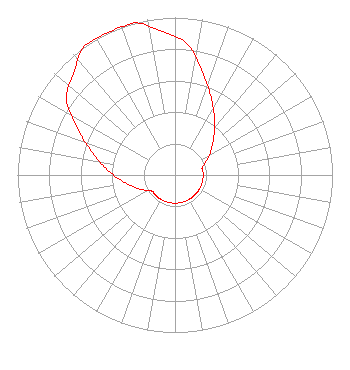 | ||||||||||||||||||
| Azimuth | Ratio | Azimuth | Ratio | Azimuth | Ratio | Azimuth | Ratio | ||||||||||||
| 5 | 0.841 | 15 | 0.676 | 25 | 0.543 | 35 | 0.436 | ||||||||||||
| 45 | 0.350 | 55 | 0.281 | 65 | 0.224 | 75 | 0.179 | ||||||||||||
| 85 | 0.179 | 95 | 0.179 | 105 | 0.179 | 115 | 0.179 | ||||||||||||
| 125 | 0.179 | 135 | 0.179 | 145 | 0.179 | 155 | 0.179 | ||||||||||||
| 165 | 0.179 | 175 | 0.179 | 185 | 0.179 | 195 | 0.179 | ||||||||||||
| 205 | 0.179 | 215 | 0.179 | 225 | 0.179 | 235 | 0.179 | ||||||||||||
| 245 | 0.224 | 255 | 0.281 | 265 | 0.350 | 275 | 0.436 | ||||||||||||
| 285 | 0.543 | 295 | 0.676 | 305 | 0.841 | 315 | 0.912 | ||||||||||||
| 325 | 1.000 | 335 | 1.000 | 345 | 1.000 | 355 | 0.912 | ||||||||||||
Structure Registration Number 1256791 Structure Type: TOWER Registered To: Hope Media Group Structure Address: 1/4 Mile East Of Indianola Road On Sw 240th Douglass, KS County Name: Butler County ASR Issued: 07/19/2023 Date Built: 07/20/2010 Site Elevation: 377.6 m (1239 ft.) Structure Height: 149 m (489 ft.) Height Overall: 149.4 m (490 ft.) Overall Height AMSL: 527 m (1729 ft.) FAA Determination: 01/03/2007 FAA Study #: 2006-ACE-3024-OE FAA Circular #: 70/7460-1K Paint & Light FAA Chapters: 4, 6, 12 Removed expiration date from determination. Scenario 1./jjs/case#635066 37-28-37.2 N 97-04-29.1 W (NAD 83) 37-28-37.1 N 97-04-28.0 W (Converted to NAD 27) |
1722 Treble Drive Humble, TX 77338 Phone: 214-353-9293 Not-for-Profit | Date: 02/16/2016 Application Certifier WAY MEDIA, INC. P.o. Box 64500 Colorado Springs, CO 80962 Applicant JAMES A. TURVAVILLE P.o. Box 64500 Colorado Springs, CO 80962 EXPANSION SPECIALIST BOB AUGSBURG Way Media, Inc. | |||||||||||||||||
| |||||||||||||||||||