
FCCInfo.com
A Service of Cavell, Mertz & Associates, Inc.
(855) FCC-INFO
|
|
|
|
|
||||||||||||||||
|
|
KJRF Channel: 216C1 91.1 MHz Lawton, Oklahoma Service: FM - A full-service FM station or application. Facility ID: 82987 Fac. Service: FM Status: License Application Accepted: 12/11/2009 Application Granted: 12/23/2009 File Number: BLED-20091211AFN License Expires: 00/00/0000 Prefix Type: This is a license for a noncommercial educational FM station Application Type: License To Cover FCC Website Links: LMS Facility Details This Application CDBS Application Other KJRF Applications Other KJRF Applications in CDBS Including Superseded Applications Mailing Address Correspondence for KJRF Correspondence related to application BLED-20091211AFN Service Contour - Open Street Map or USGS Map (60 dBu) Service Contour - KML / Google Earth (60 dBu) Public Inspection Files Facility Type: NON-COMMERCIAL EDUC. FM Class: C1, A Zone II station; with 50kW-100kW ERP and a class contour distance 52km-72km Site Location: 34-41-22.3 N 98-07-35.2 W (NAD 83) Site Location: 34-41-22.0 N 98-07-34.0 W (Converted to NAD 27) Effective Radiated Power: 100 kW Transmitter Output Power: 16.6 kW Antenna Center HAAT: 126 m (413 ft.) Antenna Center AMSL: 492 m (1614 ft.) Antenna Center HAG: 114 m (374 ft.) Calculated Site Elevation: 378 m. (1240 ft.) Height Overall*: 123 m (404 ft.) (* As Filed In This Application, may differ from ASR Data, Below.) Directional Antenna Antenna Make/Model: Electronics Research Inc. MP-8C-DA-HW Antenna ID: 93195 Polarization: | ||||||||||||||||||
| Antenna Data for Antenna Id: 93195 KJRF FM File: BLED-20091211AFN Electronics Research Inc. - MP-8C-DA-HW Service: FM | 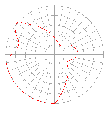 | ||||||||||||||||||
| Azimuth | Ratio | Azimuth | Ratio | Azimuth | Ratio | Azimuth | Ratio | ||||||||||||
| 0 | 0.346 | 5 | 0.307 | 10 | 0.279 | 15 | 0.267 | ||||||||||||
| 20 | 0.257 | 25 | 0.238 | 30 | 0.222 | 35 | 0.224 | ||||||||||||
| 40 | 0.245 | 45 | 0.272 | 50 | 0.303 | 60 | 0.376 | ||||||||||||
| 70 | 0.430 | 80 | 0.458 | 90 | 0.483 | 100 | 0.422 | ||||||||||||
| 110 | 0.347 | 120 | 0.295 | 130 | 0.343 | 140 | 0.425 | ||||||||||||
| 150 | 0.526 | 160 | 0.651 | 170 | 0.807 | 180 | 1.000 | ||||||||||||
| 190 | 1.000 | 200 | 1.000 | 210 | 1.000 | 220 | 1.000 | ||||||||||||
| 230 | 1.000 | 240 | 1.000 | 250 | 1.000 | 260 | 1.000 | ||||||||||||
| 270 | 0.881 | 280 | 0.768 | 290 | 0.780 | 300 | 0.922 | ||||||||||||
| 310 | 1.000 | 320 | 0.803 | 330 | 0.658 | 340 | 0.531 | ||||||||||||
| 350 | 0.429 | ||||||||||||||||||
Structure Registration Number 1032948 Structure Type: Registered To: CHRISTIAN CENTER Structure Address: 4.8 Km S 5.6 Km E Sterling, OK County Name: Comanche County ASR Issued: 11/04/1997 Date Built: 11/30/2001 Site Elevation: 378 m (1240 ft.) Structure Height: 122 m (400 ft.) Height Overall: 122.8 m (403 ft.) Overall Height AMSL: 500.8 m (1643 ft.) FAA Determination: 07/08/1996 FAA Study #: 96-ASW-1432-OE FAA Circular #: 70/7460-1J Paint & Light FAA Chapters: 3, 4, 5, 13 34-41-22.0 N 98-07-35.0 W (NAD 83) 34-41-21.7 N 98-07-33.8 W (Converted to NAD 27) |
2405 Sw Lee Blvd. Lawton, OK 73505 Phone: 580-357-4498 Not-for-Profit | Date: 12/11/2009 Application Certifier THE CHRISTIAN CENTER, INC. 2405 Sw Lee Blvd. Lawton, OK 73505-8308 Applicant LARRY P. WAGGONER 8112 West Meadow Pass Wichita, KS 67205-1647 TECHNICAL CONSULTANT JOSEPH C. CHAUTIN, III, ESQ. Hardy, Carey, Chautin & Balkin, Llp | |||||||||||||||||
| |||||||||||||||||||