
FCCInfo.com
A Service of Cavell, Mertz & Associates, Inc.
(855) FCC-INFO
|
|
WENZ from 04/09/1987 |
|  |
|
||||||||||||||||||
|
|
WENZ Channel: 300B 107.9 MHz Cleveland, Ohio Service: FM - A full-service FM station or application. Facility ID: 2685 Fac. Service: FM Analog & Digital Status: License Application Accepted: 02/20/1987 Application Granted: 09/21/1992 File Number: BLH-19870220KG License Expires: 10/01/1996 Prefix Type: This is a license for a commercial FM station Application Type: License To Cover FCC Website Links: LMS Facility Details This Application CDBS Application Other WENZ Applications Other WENZ Applications in CDBS Including Superseded Applications Mailing Address Correspondence for WENZ Correspondence related to application BLH-19870220KG Service Contour - Open Street Map or USGS Map (54 dBu) Service Contour - KML / Google Earth (54 dBu) Public Inspection Files History Cards for WENZ Facility Type: FM STATION Class: B, A Zone I or I-A station; with 25kW-50kW ERP and a class contour distance 39km-52km Site Location: 41-27-54.2 N 81-17-12.4 W (NAD 83) Site Location: 41-27-54.0 N 81-17-13.0 W (Converted to NAD 27) Effective Radiated Power: 16 kW Horiz. ; 15 kW Vert. Antenna Center HAAT: 272 m (892 ft.) Antenna Center AMSL: 613 m (2011 ft.) Antenna Center HAG: 226 m (741 ft.) Site Elevation: 387 m. (1270 ft.) Height Overall*: 228.6 m (750 ft.) (* As Filed In This Application, may differ from ASR Data, Below.) Directional Antenna Antenna Make/Model: Oddball; usually designed by Applicant ODD860818IC Antenna ID: 13714 Polarization: | |||||||||||||||||||||
| Antenna Data for Antenna Id: 13714 WENZ FM File: BLH-19870220KG Oddball; usually designed by Applicant - ODD860818IC Service: FM | 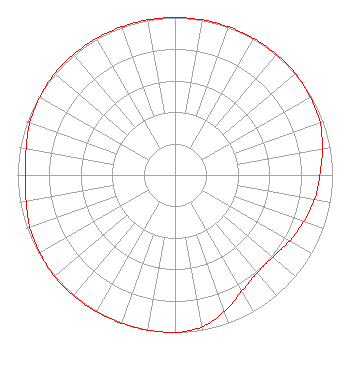 | |||||||||||||||||||||
| Azimuth | Ratio | Azimuth | Ratio | Azimuth | Ratio | Azimuth | Ratio | |||||||||||||||
| 0 | 1.000 | 10 | 1.000 | 20 | 1.000 | 30 | 1.000 | |||||||||||||||
| 40 | 1.000 | 50 | 1.000 | 60 | 0.990 | 70 | 0.980 | |||||||||||||||
| 80 | 0.950 | 90 | 0.920 | 100 | 0.900 | 110 | 0.870 | |||||||||||||||
| 120 | 0.840 | 130 | 0.810 | 140 | 0.810 | 150 | 0.850 | |||||||||||||||
| 160 | 0.920 | 170 | 0.980 | 180 | 1.000 | 190 | 1.000 | |||||||||||||||
| 200 | 1.000 | 210 | 1.000 | 220 | 1.000 | 230 | 1.000 | |||||||||||||||
| 240 | 0.990 | 250 | 0.980 | 260 | 0.960 | 270 | 0.950 | |||||||||||||||
| 280 | 0.960 | 290 | 0.980 | 300 | 0.990 | 310 | 1.000 | |||||||||||||||
| 320 | 1.000 | 330 | 1.000 | 340 | 1.000 | 350 | 1.000 | |||||||||||||||
Structure Registration Number 1020837 [ASR Heights Differ from WENZ Application] Structure Type: GTOWER Registered To: American Towers LLC Structure Address: 18147/14781 Sperry Road (202591) Newbury, OH County Name: Geauga County ASR Issued: 11/02/2022 Date Built: 01/01/1985 Site Elevation: 386.2 m (1267 ft.) Structure Height: 217.9 m (715 ft.) Height Overall: 228.3 m (749 ft.) Overall Height AMSL: 614.5 m (2016 ft.) FAA Determination: 10/24/2022 FAA Study #: 2021-AGL-28787-OE FAA Circular #: 70/7460-1L Paint & Light FAA Chapters: 4, 9, 12 PRIOR STUDY 2018-AGL-3769-OE 41-27-52.4 N 81-17-12.5 W (NAD 83) 41-27-52.2 N 81-17-13.1 W (Converted to NAD 27) |
1010 Wayne Avenue 14th Floor Silver Spring, MD 20910 Phone: 301-429-4634 Limited Liability Company | Date: 02/20/1987 Application Certifier RADIO ONE LICENSES, INC. Ardman Broadcasting Corp. Of Ohio 5900 Princess Garden Parkway 8th Floor Lanham, MD 20706 Applicant | ||||||||||||||||||||
| ||||||||||||||||||||||