
FCCInfo.com
A Service of Cavell, Mertz & Associates, Inc.
(855) FCC-INFO
|
|
|
|  |
|
|||||||||||||||
|
|
WJFH Channel: 219A 91.7 MHz Sebring, Florida Service: FM - A full-service FM station or application. Facility ID: 81147 Fac. Service: FM Status: License Application Accepted: 11/21/2013 Application Granted: 12/05/2013 File Number: BLED-20131121AVS License Expires: 00/00/0000 Prefix Type: This is a license for a noncommercial educational FM station Application Type: License To Cover FCC Website Links: LMS Facility Details This Application CDBS Application Other WJFH Applications Other WJFH Applications in CDBS Including Superseded Applications Mailing Address Correspondence for WJFH Correspondence related to application BLED-20131121AVS Service Contour - Open Street Map or USGS Map (60 dBu) Service Contour - KML / Google Earth (60 dBu) Public Inspection Files Facility Type: NON-COMMERCIAL EDUC. FM Class: A, A Zone I; I-A; or II station; with 0.1kW-6kW ERP and a class contour distance <=28km Site Location: 27-22-53.1 N 81-29-27.3 W (NAD 83) Site Location: 27-22-52.0 N 81-29-28.0 W (Converted to NAD 27) Effective Radiated Power: 2 kW Transmitter Output Power: 0.963 kW Antenna Center HAAT: 137.1 m (450 ft.) Antenna Center AMSL: 165.5 m (543 ft.) Antenna Center HAG: 132.3 m (434 ft.) Calculated Site Elevation: 33.2 m. (109 ft.) Height Overall*: 141.1 m (463 ft.) (* As Filed In This Application, may differ from ASR Data, Below.) Directional Antenna Antenna Make/Model: Shivley 6810-2/1-IAD-DA, 2 sections Antenna ID: 113700 Polarization: | ||||||||||||||||||
| Antenna Data for Antenna Id: 113700 WJFH FM File: BLED-20131121AVS Shivley - 6810-2/1-IAD-DA, 2 sections Service: FM | 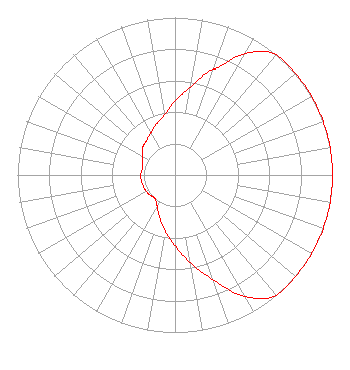 | ||||||||||||||||||
| Azimuth | Ratio | Azimuth | Ratio | Azimuth | Ratio | Azimuth | Ratio | ||||||||||||
| 0 | 0.471 | 10 | 0.566 | 20 | 0.711 | 21 | 0.728 | ||||||||||||
| 30 | 0.893 | 40 | 1.000 | 45 | 1.000 | 50 | 1.000 | ||||||||||||
| 60 | 1.000 | 70 | 1.000 | 80 | 1.000 | 90 | 1.000 | ||||||||||||
| 100 | 1.000 | 110 | 1.000 | 120 | 1.000 | 130 | 1.000 | ||||||||||||
| 135 | 1.000 | 140 | 1.000 | 150 | 0.891 | 160 | 0.710 | ||||||||||||
| 170 | 0.566 | 180 | 0.450 | 190 | 0.359 | 200 | 0.285 | ||||||||||||
| 210 | 0.227 | 220 | 0.196 | 225 | 0.196 | 230 | 0.202 | ||||||||||||
| 240 | 0.210 | 250 | 0.213 | 260 | 0.216 | 270 | 0.218 | ||||||||||||
| 280 | 0.212 | 290 | 0.220 | 300 | 0.238 | 310 | 0.268 | ||||||||||||
| 315 | 0.276 | 320 | 0.284 | 330 | 0.309 | 340 | 0.345 | ||||||||||||
| 350 | 0.387 | ||||||||||||||||||
Structure Registration Number 1055420 [ASR Heights Differ from WJFH Application] Structure Type: GTOWER Registered To: SBA Properties, LLC Structure Address: 5115 West Josephine Road (fl02584-a) Lake Placid, FL County Name: Highlands County ASR Issued: 12/06/2023 Date Built: 09/26/1988 Site Elevation: 31.1 m (102 ft.) Structure Height: 137.2 m (450 ft.) Height Overall: 137.8 m (452 ft.) Overall Height AMSL: 168.9 m (554 ft.) FAA Determination: 07/19/2023 FAA Study #: 2023-ASO-17919-OE FAA Circular #: 70/7460-1L Paint & Light FAA Chapters: 4, 8, 12 OM&L to remain the same as prior study = A MED-DUAL SYSTEM 27-22-52.9 N 81-29-27.8 W (NAD 83) 27-22-51.8 N 81-29-28.5 W (Converted to NAD 27) |
P.o. Box 7217 Lakeland, FL 33807-7217 Phone: 863-644-3464 Not-for-Profit | Date: 11/21/2013 Application Certifier RADIO TRAINING NETWORK, INC. P.o. Box 7217 Lakeland, FL 33807-7217 Applicant R. STUART GRAHAM Graham Brock, Inc. P. O. Bo 24466 St. Simons Island, GA 31522-7466 TECHNICAL CONSULTANT A. WRAY FITCH III Gammon & Grange, P.c. | |||||||||||||||||