
FCCInfo.com
A Service of Cavell, Mertz & Associates, Inc.
(855) FCC-INFO
|
|
|
|
|
|||||||||||||||||||
|
|
KQMQ-FM Channel: 226C 93.1 MHz Honolulu, Hawaii Service: FM - A full-service FM station or application. Facility ID: 16745 Fac. Service: FM Status: License Application Accepted: 04/25/1997 Application Granted: 07/16/1997 File Number: BLH-19970425KE License Expires: 00/00/0000 Prefix Type: This is a license for a commercial FM station Application Type: License To Cover FCC Website Links: LMS Facility Details This Application CDBS Application Other KQMQ-FM Applications Other KQMQ-FM Applications in CDBS Including Superseded Applications Mailing Address Correspondence for KQMQ-FM Correspondence related to application BLH-19970425KE Service Contour - Open Street Map or USGS Map (60 dBu) Service Contour - KML / Google Earth (60 dBu) Public Inspection Files History Cards for KQMQ-FM Facility Type: FM STATION Class: C, A Zone II station; with exactly 100kW ERP and a class contour distance 72km-92km Site Location: 21-23-45.0 N 158-05-58.0 W (NAD 83) Site Location: 21-23-56.4 N 158-06-07.9 W (Converted to NAD 27) Effective Radiated Power: 100 kW Antenna Center HAAT: 565 m (1854 ft.) Antenna Center AMSL: 734 m (2408 ft.) Antenna Center HAG: 39 m (128 ft.) Calculated Site Elevation: 695 m. (2280 ft.) Height Overall*: 61 m (200 ft.) (* As Filed In This Application, may differ from ASR Data, Below.) Directional Antenna Antenna Make/Model: Oddball; usually designed by Applicant ODD960222IB Antenna ID: 14922 Polarization: | |||||||||||||||||||||
| Antenna Data for Antenna Id: 14922 KQMQ-FM FM File: BLH-19970425KE Oddball; usually designed by Applicant - ODD960222IB Service: FM | 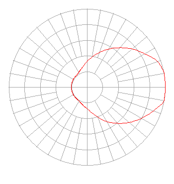 | |||||||||||||||||||||
| Azimuth | Ratio | Azimuth | Ratio | Azimuth | Ratio | Azimuth | Ratio | |||||||||||||||
| 0 | 0.325 | 10 | 0.390 | 20 | 0.470 | 30 | 0.560 | |||||||||||||||
| 40 | 0.655 | 50 | 0.755 | 60 | 0.850 | 70 | 0.955 | |||||||||||||||
| 80 | 1.000 | 90 | 1.000 | 100 | 1.000 | 110 | 0.900 | |||||||||||||||
| 120 | 0.800 | 130 | 0.705 | 140 | 0.605 | 150 | 0.510 | |||||||||||||||
| 160 | 0.410 | 170 | 0.330 | 180 | 0.275 | 190 | 0.245 | |||||||||||||||
| 200 | 0.220 | 210 | 0.205 | 220 | 0.200 | 230 | 0.200 | |||||||||||||||
| 240 | 0.200 | 250 | 0.200 | 260 | 0.200 | 270 | 0.200 | |||||||||||||||
| 280 | 0.200 | 290 | 0.200 | 300 | 0.200 | 310 | 0.200 | |||||||||||||||
| 320 | 0.200 | 330 | 0.215 | 340 | 0.235 | 350 | 0.270 | |||||||||||||||
Structure Registration Number 1218023 Structure Type: TOWER Registered To: Salem Media of Hawaii Structure Address: Palikea Ridge, 26.9 Km Nw Of Honolulu At 292° True Makakilo, HI County Name: Honolulu County ASR Issued: 10/03/2000 Date Built: 10/03/2000 Site Elevation: 695.1 m (2281 ft.) Structure Height: 60.6 m (199 ft.) Height Overall: 60.6 m (199 ft.) Overall Height AMSL: 755.7 m (2479 ft.) FAA Determination: 09/08/2000 FAA Study #: 00-AWP-2258-OE Paint & Light FAA Chapters: NONE 21-23-33.6 N 158-05-48.1 W (NAD 83) 21-23-45.0 N 158-05-58.0 W (Converted to NAD 27) |
311 Ano St. Kahului, HI 96732 Phone: 808-877-5566 Corporation | Date: 04/25/1997 Application Certifier NEW WAVE BROADCASTING, L.P. New Wave Broadcasting, L.p. 1833 Kalkaua Avenue, Suite 500 Honolulu, HI 96815 Applicant | ||||||||||||||||||||
| ||||||||||||||||||||||