
FCCInfo.com
A Service of Cavell, Mertz & Associates, Inc.
(855) FCC-INFO
|
|
W258AL from 03/23/2007 W258AL from 04/07/2004 |
|
|
||||||||||||||||
|
|
W258AL Channel: 258D 99.5 MHz Clinton, Connecticut Service: FX - A translator or application for a translator. Facility ID: 139348 Fac. Service: FX Programming Delivery Method: Unspecified Status: License Application Accepted: 11/24/2014 Application Granted: 12/10/2014 File Number: BLFT-20141124AJK License Expires: 00/00/0000 Prefix Type: This is a license for a translator Application Type: Amendment FCC Website Links: LMS Facility Details This Application CDBS Application Other W258AL Applications Other W258AL Applications in CDBS Including Superseded Applications Mailing Address Correspondence for W258AL Correspondence related to application BLFT-20141124AJK Service Contour - Open Street Map or USGS Map (60 dBu) Service Contour - KML / Google Earth (60 dBu) Class: D, A Noncommercial educational operating with no more than 10W Site Location: 41-34-11.3 N 73-01-03.4 W (NAD 83) Site Location: 41-34-11.0 N 73-01-05.0 W (Converted to NAD 27) Effective Radiated Power: 0.2 kW Transmitter Output Power: 0.092 kW Antenna Center HAAT: 0 m Antenna Center AMSL: 334 m (1096 ft.) Antenna Center HAG: 80 m (262 ft.) Site Elevation: 254 m. (833 ft.) Height Overall*: 91 m (299 ft.) (* As Filed In This Application, may differ from ASR Data, Below.) Directional Antenna Antenna Make/Model: None Antenna ID: 119151 Polarization:
| ||||||||||||||||||
| Antenna Data for Antenna Id: 119151 W258AL FX File: BLFT-20141124AJK None - Service: FX | 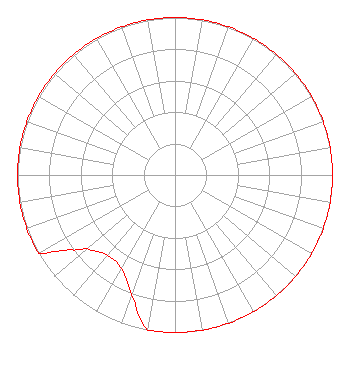 | ||||||||||||||||||
| Azimuth | Ratio | Azimuth | Ratio | Azimuth | Ratio | Azimuth | Ratio | ||||||||||||
| 0 | 1.000 | 10 | 1.000 | 20 | 1.000 | 30 | 1.000 | ||||||||||||
| 40 | 1.000 | 50 | 1.000 | 60 | 1.000 | 70 | 1.000 | ||||||||||||
| 80 | 1.000 | 90 | 1.000 | 100 | 1.000 | 110 | 1.000 | ||||||||||||
| 120 | 1.000 | 130 | 1.000 | 140 | 1.000 | 150 | 1.000 | ||||||||||||
| 160 | 1.000 | 170 | 1.000 | 180 | 1.000 | 190 | 1.000 | ||||||||||||
| 200 | 0.805 | 210 | 0.685 | 220 | 0.665 | 230 | 0.725 | ||||||||||||
| 233 | 0.790 | 235 | 0.830 | 238 | 0.920 | 240 | 1.000 | ||||||||||||
| 250 | 1.000 | 260 | 1.000 | 270 | 1.000 | 280 | 1.000 | ||||||||||||
| 290 | 1.000 | 300 | 1.000 | 310 | 1.000 | 320 | 1.000 | ||||||||||||
| 330 | 1.000 | 340 | 1.000 | 350 | 1.000 | ||||||||||||||
Structure Registration Number 1046927 [ASR Heights Differ from W258AL Application] Structure Type: TOWER Registered To: SBA Properties, LLC Structure Address: New Haven County Waterbury, CT County Name: New Haven County ASR Issued: 04/25/2013 Date Built: 04/01/1987 Site Elevation: 253.5 m (832 ft.) Structure Height: 85.3 m (280 ft.) Height Overall: 90.8 m (298 ft.) Overall Height AMSL: 344.3 m (1130 ft.) FAA Determination: 11/07/2002 FAA Study #: 2002-ANE-978-OE FAA Circular #: 70/7460-1K Paint & Light FAA Chapters: 4, 6, 12 Removed expiration date from determination. Scenario 1./jjs/case#635066 41-34-11.0 N 73-01-03.0 W (NAD 83) 41-34-10.7 N 73-01-04.6 W (Converted to NAD 27) |
Po Box 357 758 Colonel Ledyard Highway Ledyard, CT 06339 Phone: 860-883-4292 | Date: 11/24/2014 Application Certifier RED WOLF BROADCASTING CORPORATION 758 Colonel Ledyard Highway P.o. Box 357 Ledyard, CT 06339 Applicant W. JEFFREY REYNOLDS Du Treil, Lundin & Rackley, Inc. 201 Fletcher Avenue Sarasota, FL 34237-6019 TECHNICAL CONSULTANT SCOTT WOODWORTH Edinger Associates Pllc 1875 I Street Nw Suite 500 Washington, DC 20006 | |||||||||||||||||