
FCCInfo.com
A Service of Cavell, Mertz & Associates, Inc.
(855) FCC-INFO
|
|
W241CI from 04/26/2013 |
|
|
||||||||||||||||
|
|
W241CI Channel: 241D 96.1 MHz Milwaukee, Wisconsin Service: FX - A translator or application for a translator. Facility ID: 144520 Fac. Service: FX Programming Delivery Method: Unspecified Status: License Application Accepted: 12/21/2017 Application Granted: 01/31/2018 File Number: BLFT-20171221AFF License Expires: 00/00/0000 Prefix Type: This is a license for a translator Application Type: Amendment FCC Website Links: LMS Facility Details This Application CDBS Application Other W241CI Applications Other W241CI Applications in CDBS Including Superseded Applications Mailing Address Correspondence for W241CI Correspondence related to application BLFT-20171221AFF Service Contour - Open Street Map or USGS Map (60 dBu) Service Contour - KML / Google Earth (60 dBu) Class: D, A Noncommercial educational operating with no more than 10W Site Location: 43-02-21.1 N 87-55-09.3 W (NAD 83) Site Location: 43-02-21.1 N 87-55-09.0 W (Converted to NAD 27) Effective Radiated Power: 0.099 kW Transmitter Output Power: 0.242 kW Antenna Center HAAT: 0 m Antenna Center AMSL: 264 m (866 ft.) Antenna Center HAG: 80 m (262 ft.) Site Elevation: 184 m. (604 ft.) Height Overall*: 101 m (331 ft.) (* As Filed In This Application, may differ from ASR Data, Below.) Directional Antenna Antenna Make/Model: None Antenna ID: 127168 Polarization:
| ||||||||||||||||||
| Antenna Data for Antenna Id: 127168 W241CI FX File: BLFT-20171221AFF None - Service: FX Pattern and Field Values Include a 315° Clockwise Rotation | 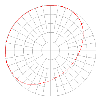 | ||||||||||||||||||
| Azimuth | Ratio | Azimuth | Ratio | Azimuth | Ratio | Azimuth | Ratio | ||||||||||||
| 5 | 0.992 | 15 | 1.000 | 25 | 0.991 | 35 | 0.963 | ||||||||||||
| 45 | 0.923 | 55 | 0.862 | 65 | 0.797 | 75 | 0.731 | ||||||||||||
| 85 | 0.676 | 95 | 0.628 | 105 | 0.594 | 115 | 0.571 | ||||||||||||
| 125 | 0.558 | 135 | 0.553 | 145 | 0.558 | 155 | 0.571 | ||||||||||||
| 165 | 0.594 | 175 | 0.628 | 185 | 0.682 | 195 | 0.738 | ||||||||||||
| 205 | 0.815 | 215 | 0.897 | 225 | 0.953 | 235 | 0.973 | ||||||||||||
| 245 | 0.983 | 255 | 1.000 | 265 | 0.992 | 275 | 0.988 | ||||||||||||
| 285 | 0.988 | 295 | 0.983 | 305 | 0.983 | 315 | 0.983 | ||||||||||||
| 325 | 0.983 | 335 | 0.983 | 345 | 0.988 | 355 | 0.988 | ||||||||||||
Structure Registration Number 1260337 [ASR Heights Differ from W241CI Application] Structure Type: BANT Registered To: MILWAUKEE RADIO ALLIANCE Structure Address: 606 W. Wisconsin Ave. Milwaukee, WI County Name: Milwaukee County ASR Issued: 10/10/2007 Site Elevation: 184.1 m (604 ft.) Structure Height: 76.2 m (250 ft.) Height Overall: 100.5 m (330 ft.) Overall Height AMSL: 284.6 m (934 ft.) FAA Determination: 06/28/2007 FAA Study #: 2007-AGL-4498-OE FAA Circular #: 70/7460-1K Paint & Light FAA Chapters: 4, 5, 12 43-02-21.0 N 87-55-09.3 W (NAD 83) 43-02-21.0 N 87-55-09.0 W (Converted to NAD 27) |
7833 West Burleigh Street Milwaukee, WI 53222 Phone: 414-527-4000 | Date: 12/21/2017 Application Certifier J.KINLOW & A.KINLOW-GLOSSON, CO-PERS. REPS., J.KINLOW ESTATE Po Box 091036 Milwaukee, WI 53209-8036 Applicant MARK A. MUELLER Mueller Broadcast Design 613 S. La Grange Rd. La Grange, IL 60525-5601 TECHNICAL CONSULTANT MARK B. DENBO Smithwick & Belendiuk, P.c. Suite 301 5028 Wisconsin Avenue, N.w. Washington, DC 20016 | |||||||||||||||||