
FCCInfo.com
A Service of Cavell, Mertz & Associates, Inc.
(855) FCC-INFO
|
|
WTHL from 03/20/1986 |
|  |
|
|||||||||||||||
|
|
WTHL Channel: 213C1 90.5 MHz Somerset, Kentucky Service: FM - A full-service FM station or application. Facility ID: 60782 Fac. Service: FM Status: License Application Accepted: 10/07/1999 Application Granted: 10/18/1999 File Number: BLED-19990930AAI License Expires: 00/00/0000 Prefix Type: This is a license for a noncommercial educational FM station Application Type: License To Cover FCC Website Links: LMS Facility Details This Application CDBS Application Other WTHL Applications Other WTHL Applications in CDBS Including Superseded Applications Mailing Address Correspondence for WTHL Correspondence related to application BLED-19990930AAI Service Contour - Open Street Map or USGS Map (60 dBu) Service Contour - KML / Google Earth (60 dBu) Public Inspection Files Facility Type: NON-COMMERCIAL EDUC. FM Class: C1, A Zone II station; with 50kW-100kW ERP and a class contour distance 52km-72km Site Location: 37-07-52.3 N 84-33-14.8 W (NAD 83) Site Location: 37-07-52.0 N 84-33-15.0 W (Converted to NAD 27) Effective Radiated Power: 50 kW Transmitter Output Power: 9.21 kW Antenna Center HAAT: 180 m (591 ft.) Antenna Center AMSL: 485 m (1591 ft.) Antenna Center HAG: 61 m (200 ft.) Calculated Site Elevation: 424 m. (1391 ft.) Height Overall*: 81 m (266 ft.) (* As Filed In This Application, may differ from ASR Data, Below.) Directional Antenna Antenna Make/Model: Electronics Research Inc. LP-8C-DA Antenna ID: 15636 Polarization: | ||||||||||||||||||
| Antenna Data for Antenna Id: 15636 WTHL FM File: BLED-19990930AAI Electronics Research Inc. - LP-8C-DA Service: FM | 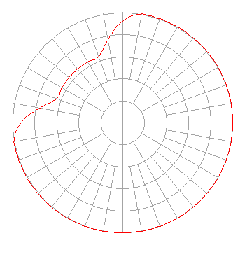 | ||||||||||||||||||
| Azimuth | Ratio | Azimuth | Ratio | Azimuth | Ratio | Azimuth | Ratio | ||||||||||||
| 0 | 0.920 | 10 | 1.000 | 20 | 1.000 | 30 | 1.000 | ||||||||||||
| 40 | 1.000 | 50 | 1.000 | 60 | 1.000 | 70 | 1.000 | ||||||||||||
| 80 | 1.000 | 90 | 1.000 | 100 | 1.000 | 110 | 1.000 | ||||||||||||
| 120 | 1.000 | 130 | 1.000 | 140 | 1.000 | 150 | 1.000 | ||||||||||||
| 160 | 1.000 | 170 | 1.000 | 180 | 1.000 | 190 | 1.000 | ||||||||||||
| 200 | 1.000 | 210 | 1.000 | 220 | 1.000 | 230 | 1.000 | ||||||||||||
| 240 | 1.000 | 250 | 1.000 | 260 | 1.000 | 270 | 0.920 | ||||||||||||
| 280 | 0.760 | 290 | 0.632 | 300 | 0.632 | 310 | 0.632 | ||||||||||||
| 320 | 0.632 | 330 | 0.632 | 340 | 0.632 | 350 | 0.760 | ||||||||||||
Structure Registration Number 1051877 Structure Type: TOWER Registered To: Somerset Educational Broadcasting Foundation Structure Address: Adjacent To W Hwy 80 E Somerset, KY County Name: Pulaski County ASR Issued: 12/06/2005 Date Built: 01/01/1986 Site Elevation: 424.2 m (1392 ft.) Structure Height: 79.3 m (260 ft.) Height Overall: 80.8 m (265 ft.) Overall Height AMSL: 505 m (1657 ft.) FAA Determination: 08/14/1986 FAA Study #: 86-ASO-605-OE Paint & Light FAA Chapters: 1, 3, 11, 21 RED LIGHTS/PAINT 37-07-52.0 N 84-33-15.0 W (NAD 83) 37-07-51.7 N 84-33-15.2 W (Converted to NAD 27) |
P.o. Box 1423 Somerset, KY 42502 Phone: 606-679-6300 Private Not-for-Profit Educational Institution | Date: 09/30/1999 Application Certifier SOMERSET EDUCATIONAL BROADCASTING FOUNDATION 93 Rainbow Terrace Road Somerset, KY 60782 Applicant TECHNICAL DIRECTOR | |||||||||||||||||
|
| ||||||||||||||||||