
FCCInfo.com
A Service of Cavell, Mertz & Associates, Inc.
(855) FCC-INFO
|
|
WBPR from 09/13/1991 WBPR from 03/25/1991 |
|  |
|
|||||||||||||||
|
|
WBPR Channel: 220A 91.9 MHz Worcester, Massachusetts Service: FM - A full-service FM station or application. Facility ID: 69163 Fac. Service: FM Analog & Digital Status: License 73.215 Station Application Accepted: 08/27/2013 Application Granted: 08/29/2013 File Number: BLED-20130827ABF License Expires: 00/00/0000 Prefix Type: This is a license for a noncommercial educational FM station Application Type: License To Cover FCC Website Links: LMS Facility Details This Application CDBS Application Other WBPR Applications Other WBPR Applications in CDBS Including Superseded Applications Mailing Address Correspondence for WBPR Correspondence related to application BLED-20130827ABF Service Contour - Open Street Map or USGS Map (60 dBu) Service Contour - KML / Google Earth (60 dBu) Public Inspection Files Facility Type: NON-COMMERCIAL EDUC. FM Class: A, A Zone I; I-A; or II station; with 0.1kW-6kW ERP and a class contour distance <=28km Site Location: 42-18-11.3 N 71-53-50.3 W (NAD 83) Site Location: 42-18-11.0 N 71-53-52.0 W (Converted to NAD 27) Effective Radiated Power: 0.27 kW Transmitter Output Power: 0.159 kW Antenna Center HAAT: 213 m (699 ft.) Antenna Center AMSL: 449 m (1473 ft.) Antenna Center HAG: 29 m (95 ft.) Calculated Site Elevation: 420 m. (1378 ft.) Height Overall*: 77 m (253 ft.) (* As Filed In This Application, may differ from ASR Data, Below.) Directional Antenna Antenna Make/Model: Shivley 6810-2R-SS-DA Antenna ID: 110182 Polarization:
| ||||||||||||||||||
| Antenna Data for Antenna Id: 110182 WBPR FM File: BLED-20130827ABF Shivley - 6810-2R-SS-DA Service: FM | 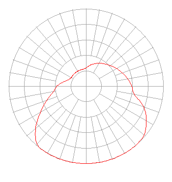 | ||||||||||||||||||
| Azimuth | Ratio | Azimuth | Ratio | Azimuth | Ratio | Azimuth | Ratio | ||||||||||||
| 0 | 0.235 | 10 | 0.270 | 20 | 0.305 | 30 | 0.340 | ||||||||||||
| 40 | 0.375 | 50 | 0.410 | 60 | 0.455 | 70 | 0.500 | ||||||||||||
| 80 | 0.545 | 90 | 0.590 | 100 | 0.635 | 110 | 0.794 | ||||||||||||
| 120 | 0.900 | 130 | 0.980 | 140 | 1.000 | 150 | 1.000 | ||||||||||||
| 160 | 1.000 | 170 | 1.000 | 180 | 1.000 | 190 | 1.000 | ||||||||||||
| 200 | 1.000 | 210 | 1.000 | 220 | 0.980 | 230 | 0.850 | ||||||||||||
| 240 | 0.680 | 250 | 0.540 | 260 | 0.430 | 270 | 0.375 | ||||||||||||
| 280 | 0.300 | 290 | 0.240 | 300 | 0.220 | 310 | 0.220 | ||||||||||||
| 320 | 0.220 | 330 | 0.220 | 340 | 0.220 | 350 | 0.220 | ||||||||||||
Structure Registration Number 1003939 Structure Type: TOWER Registered To: RADIO TOWER COMMUNICATION CORP Structure Address: Asnebumskit Rd Paxton, MA County Name: Worcester County ASR Issued: 11/15/1996 Date Built: 01/01/1933 Site Elevation: 420.3 m (1379 ft.) Structure Height: 74.6 m (245 ft.) Height Overall: 76.8 m (252 ft.) Overall Height AMSL: 497.1 m (1631 ft.) FAA Determination: 01/31/1996 FAA Study #: 95-ANE-0472-OE FAA Circular #: 70/7460-1H Paint & Light FAA Chapters: 3, 4, 5, 13 42-18-11.0 N 71-53-50.0 W (NAD 83) 42-18-10.7 N 71-53-51.7 W (Converted to NAD 27) |
100 Morrissey Boulevard Boston, MA 02125 | Date: 08/27/2013 Application Certifier UNIVERSITY OF MASSACHUSETTS 100 Morrissey Boulevard Boston, MA 02125-3393 Applicant DAVID J DOHERTY Skywaves Consulting Llc Po Box 4 Millbury, MA 01527-0004 TECHNICAL CONSULTANT JOHN F. GARZIGLIA, ESQ. Womble Carlyle Sandridge & Rice, Llp | |||||||||||||||||