
FCCInfo.com
A Service of Cavell, Mertz & Associates, Inc.
(855) FCC-INFO
|
|
|
|
|
||||||||||||||||
|
|
K219FF Channel: 219D 91.7 MHz Havre, Montana Service: FX - A translator or application for a translator. Facility ID: 122867 Fac. Service: FX Programming Delivery Method: Unspecified Status: License Application Accepted: 01/03/2001 Application Granted: 03/07/2001 File Number: BLFT-20001218ADA License Expires: 00/00/0000 Prefix Type: This is a license for a translator Application Type: License To Cover FCC Website Links: LMS Facility Details This Application CDBS Application Other K219FF Applications Other K219FF Applications in CDBS Including Superseded Applications Mailing Address Correspondence for K219FF Correspondence related to application BLFT-20001218ADA Service Contour - Open Street Map or USGS Map (60 dBu) Service Contour - KML / Google Earth (60 dBu) Class: D, A Noncommercial educational operating with no more than 10W Site Location: 48-32-55.0 N 109-42-12.7 W (NAD 83) Site Location: 48-32-55.0 N 109-42-10.0 W (Converted to NAD 27) Effective Radiated Power: 0.25 kW Transmitter Output Power: 0.25 kW Antenna Center HAAT: 4 m Horiz.; 0 m Vert. Antenna Center AMSL: 837.4 m (2747 ft.) Antenna Center HAG: 23 m (75 ft.) Site Elevation: 814.4 m. (2672 ft.) Height Overall*: 24.4 m (80 ft.) (* As Filed In This Application, may differ from ASR Data, Below.) Directional Antenna Antenna Make/Model: None Antenna ID: 31804 Polarization:
| ||||||||||||||||||
| Antenna Data for Antenna Id: 31804 K219FF FX File: BLFT-20001218ADA None - Service: FX Pattern and Field Values Include a 90° Clockwise Rotation | 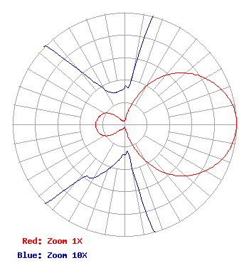 | ||||||||||||||||||
| Azimuth | Ratio | Azimuth | Ratio | Azimuth | Ratio | Azimuth | Ratio | ||||||||||||
| 0 | 0.033 | 10 | 0.050 | 20 | 0.193 | 30 | 0.397 | ||||||||||||
| 40 | 0.573 | 50 | 0.713 | 60 | 0.828 | 70 | 0.917 | ||||||||||||
| 80 | 0.980 | 90 | 1.000 | 100 | 0.978 | 110 | 0.923 | ||||||||||||
| 120 | 0.830 | 130 | 0.717 | 140 | 0.567 | 150 | 0.380 | ||||||||||||
| 160 | 0.180 | 170 | 0.040 | 180 | 0.027 | 190 | 0.033 | ||||||||||||
| 200 | 0.043 | 210 | 0.055 | 220 | 0.067 | 230 | 0.143 | ||||||||||||
| 240 | 0.203 | 250 | 0.238 | 260 | 0.253 | 270 | 0.260 | ||||||||||||
| 280 | 0.247 | 290 | 0.230 | 300 | 0.202 | 310 | 0.140 | ||||||||||||
| 320 | 0.063 | 330 | 0.037 | 340 | 0.030 | 350 | 0.030 | ||||||||||||
Structure Registration Number 1000718 Structure Type: TOWER Registered To: Spectrum Pacific West, LLC Structure Address: 800 Wilson Ave Havre, MT County Name: Hill County ASR Issued: 03/08/2019 Date Built: 01/01/1978 Site Elevation: 814.4 m (2672 ft.) Structure Height: 24.4 m (80 ft.) Height Overall: 24.4 m (80 ft.) Overall Height AMSL: 838.8 m (2752 ft.) FAA Determination: 04/08/1980 FAA Study #: 80-RM-106-OE Paint & Light FAA Chapters: NONE 48-32-55.0 N 109-42-13.0 W (NAD 83) 48-32-55.0 N 109-42-10.3 W (Converted to NAD 27) |
Kemc - Fm 1500 University Drive Billings, MT 59101 Phone: 406-657-2941 | Date: 12/18/2000 Application Certifier MONTANA STATE UNIVERSITY - BILLINGS 1500 North 30th Street Billings, MT 59101 Applicant SEE PAPER FORM | |||||||||||||||||