
FCCInfo.com
A Service of Cavell, Mertz & Associates, Inc.
(855) FCC-INFO
|
|
KMGJ from 12/02/1986 KMGJ from 11/28/1979 |
|
|
|||||||||||||||||||
|
|
KMGJ Channel: 226C0 93.1 MHz Grand Junction, Colorado Service: FS - A full service FM station auxiliary transmitting antenna or application. Facility ID: 47115 Fac. Service: FM Status: License Application Accepted: 05/26/2017 Application Granted: 06/06/2017 File Number: BXLH-20170526AAH License Expires: 00/00/0000 Prefix Type: This is BXLH Application Type: License To Cover FCC Website Links: LMS Facility Details This Application CDBS Application Other KMGJ Applications Other KMGJ Applications in CDBS Including Superseded Applications Mailing Address Correspondence for KMGJ Correspondence related to application BXLH-20170526AAH Service Contour - Open Street Map or USGS Map (60 dBu) Service Contour - KML / Google Earth (60 dBu) Public Inspection Files History Cards for KMGJ Facility Type: FM STATION Class: C0, C0 Site Location: 39-03-59.9 N 108-44-43.4 W (NAD 83) Site Location: 39-03-60.0 N 108-44-41.0 W (Converted to NAD 27) Effective Radiated Power: 2.3 kW Horiz. ; 1.75 kW Vert. Transmitter Output Power: 1 kW Antenna Center HAAT: 372 m (1220 ft.) Antenna Center AMSL: 2165 m (7103 ft.) Antenna Center HAG: 10 m (33 ft.) Calculated Site Elevation: 2155 m. (7070 ft.) Height Overall*: 70 m (230 ft.) (* As Filed In This Application, may differ from ASR Data, Below.) Directional Antenna Antenna Make/Model: Scala CA5-FM-FML/YA-7FML Antenna ID: 118468 Polarization:
| |||||||||||||||||||||
| Antenna Data for Antenna Id: 118468 KMGJ FS File: BXLH-20170526AAH Scala - CA5-FM-FML/YA-7FML Service: FS | 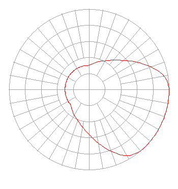 | |||||||||||||||||||||
| Azimuth | Ratio | Azimuth | Ratio | Azimuth | Ratio | Azimuth | Ratio | |||||||||||||||
| 0 | 0.300 | 10 | 0.330 | 20 | 0.370 | 30 | 0.410 | |||||||||||||||
| 40 | 0.475 | 50 | 0.560 | 60 | 0.680 | 70 | 0.820 | |||||||||||||||
| 80 | 0.950 | 90 | 1.000 | 100 | 1.000 | 110 | 1.000 | |||||||||||||||
| 120 | 1.000 | 130 | 1.000 | 140 | 1.000 | 150 | 0.950 | |||||||||||||||
| 160 | 0.820 | 170 | 0.680 | 180 | 0.560 | 190 | 0.475 | |||||||||||||||
| 200 | 0.410 | 210 | 0.370 | 220 | 0.330 | 230 | 0.300 | |||||||||||||||
| 240 | 0.300 | 250 | 0.300 | 260 | 0.300 | 270 | 0.300 | |||||||||||||||
| 280 | 0.300 | 290 | 0.300 | 300 | 0.300 | 310 | 0.300 | |||||||||||||||
| 320 | 0.300 | 330 | 0.300 | 340 | 0.300 | 350 | 0.300 | |||||||||||||||
Structure Registration Number 1022341 [ASR Heights Differ from KMGJ Application] Structure Type: GTOWER Registered To: MBC GRAND BROADCASTING, INC. Structure Address: Black Ridge Site 14 Km S Fruita, CO County Name: Mesa County ASR Issued: 04/02/2014 Date Built: 07/15/2002 Site Elevation: 2154 m (7067 ft.) Structure Height: 69 m (226 ft.) Height Overall: 70 m (230 ft.) Overall Height AMSL: 2224 m (7297 ft.) FAA Determination: 05/29/2001 FAA Study #: 2001-ANM-2186-OE Paint & Light FAA Chapters: NONE 39-03-59.7 N 108-44-43.1 W (NAD 83) 39-03-59.8 N 108-44-40.7 W (Converted to NAD 27) |
1360 East Sherwood Drive Grand Junction, CO 81501 Phone: 970-254-2112 | Date: 05/26/2017 Application Certifier MBC GRAND BROADCASTING, INC. 1360 E. Sherwood Drive Grand Junction, CO 81501 Applicant LARRY H WILL, PE 1055 Powderhorn Drive Glen Mills, PA 19342-9504 CONSULTING ENGINEER MELODIE A. VIRTUE, ESQ. Garvey Schubert Barer | ||||||||||||||||||||
|
| |||||||||||||||||||||