
FCCInfo.com
A Service of Cavell, Mertz & Associates, Inc.
(855) FCC-INFO
|
|
W249DJ from 12/19/2013 |
|
|
||||||||||||||||
|
|
W249DJ Channel: 249D 97.7 MHz Lexington, Kentucky Service: FX - A translator or application for a translator. Facility ID: 158396 Fac. Service: FX Programming Delivery Method: Unspecified Status: License Application Accepted: 11/14/2016 Application Granted: 11/23/2016 File Number: BLFT-20161114ABF License Expires: 00/00/0000 Prefix Type: This is a license for a translator Application Type: License To Cover FCC Website Links: LMS Facility Details This Application CDBS Application Other W249DJ Applications Other W249DJ Applications in CDBS Including Superseded Applications Mailing Address Correspondence for W249DJ Correspondence related to application BLFT-20161114ABF Service Contour - Open Street Map or USGS Map (60 dBu) Service Contour - KML / Google Earth (60 dBu) Class: D, A Noncommercial educational operating with no more than 10W Site Location: 38-02-06.0 N 84-27-02.0 W (NAD 83) Site Location: 38-02-05.7 N 84-27-02.2 W (Converted to NAD 27) Effective Radiated Power: 0 kW Horiz. ; 0.25 kW Vert. Transmitter Output Power: 0.089 kW Antenna Center HAAT: 0 m Antenna Center AMSL: 0 m Horiz.; 476 m Vert. Antenna Center HAG: 0 m Horiz.; 150 m Vert. Site Elevation: 326 m. (1070 ft.) Height Overall*: 162 m (531 ft.) (* As Filed In This Application, may differ from ASR Data, Below.) Directional Antenna Antenna Make/Model: None Antenna ID: 16155 Polarization:
| ||||||||||||||||||
| Antenna Data for Antenna Id: 16155 W249DJ FX File: BLFT-20161114ABF None - Service: FX Pattern and Field Values Include a 282° Clockwise Rotation | 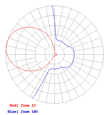 | ||||||||||||||||||
| Azimuth | Ratio | Azimuth | Ratio | Azimuth | Ratio | Azimuth | Ratio | ||||||||||||
| 2 | 0.050 | 12 | 0.030 | 22 | 0.030 | 32 | 0.030 | ||||||||||||
| 42 | 0.030 | 52 | 0.030 | 62 | 0.034 | 72 | 0.038 | ||||||||||||
| 82 | 0.040 | 92 | 0.040 | 102 | 0.040 | 112 | 0.040 | ||||||||||||
| 122 | 0.040 | 132 | 0.038 | 142 | 0.034 | 152 | 0.030 | ||||||||||||
| 162 | 0.030 | 172 | 0.030 | 182 | 0.030 | 192 | 0.030 | ||||||||||||
| 202 | 0.050 | 212 | 0.190 | 222 | 0.390 | 232 | 0.544 | ||||||||||||
| 242 | 0.690 | 252 | 0.817 | 262 | 0.916 | 272 | 0.980 | ||||||||||||
| 282 | 1.000 | 292 | 0.980 | 302 | 0.916 | 312 | 0.817 | ||||||||||||
| 322 | 0.690 | 332 | 0.544 | 342 | 0.390 | 352 | 0.190 | ||||||||||||
Structure Registration Number 1036781 Structure Type: TOWER Registered To: Vertical Bridge CC FM, LLC Structure Address: 1087 New Circle Road Lexington, KY County Name: Fayette County ASR Issued: 11/08/2018 Date Built: 04/18/1997 Site Elevation: 326.1 m (1070 ft.) Structure Height: 156.1 m (512 ft.) Height Overall: 162.4 m (533 ft.) Overall Height AMSL: 488.5 m (1603 ft.) FAA Determination: 11/26/1997 FAA Study #: 97-ASO-5146-OE FAA Circular #: 70/7460-1J Paint & Light FAA Chapters: 3, 4, 5, 13 38-02-06.0 N 84-27-02.0 W (NAD 83) 38-02-05.7 N 84-27-02.2 W (Converted to NAD 27) |
7136 S. Yale Avenue Tulsa, OK 74136 Phone: 918-664-4581 | Date: 11/14/2016 Application Certifier CLEAR CHANNEL BROADCASTING LICENSES, INC. 2625 S. Memorial Drive Suite A Tulsa, OK 74129-2623 Applicant TROY G LANGHAM 2625 S Memorial Drive Suite A Tulsa, OK 74129 FCC ENGINEERING SUPERVISOR TROY LANGHAM Iheartmedia, Inc. 2625 S. Memorial Drive Suite A Tulsa, OK 74129-2623 | |||||||||||||||||