
FCCInfo.com
A Service of Cavell, Mertz & Associates, Inc.
(855) FCC-INFO
|
|
WKJD from 05/01/1997 |
|
|
||||||||||||||||
|
|
WKJD Channel: 212A 90.3 MHz Columbus, Indiana Service: FM - A full-service FM station or application. Facility ID: 86545 Fac. Service: FM Status: License Application Accepted: 10/06/2010 Application Granted: 10/15/2010 File Number: BLED-20101006ABL License Expires: 00/00/0000 Prefix Type: This is a license for a noncommercial educational FM station Application Type: License To Cover FCC Website Links: LMS Facility Details This Application CDBS Application Other WKJD Applications Other WKJD Applications in CDBS Including Superseded Applications Mailing Address Correspondence for WKJD Correspondence related to application BLED-20101006ABL Service Contour - Open Street Map or USGS Map (60 dBu) Service Contour - KML / Google Earth (60 dBu) Public Inspection Files Facility Type: NON-COMMERCIAL EDUC. FM Class: A, A Zone I; I-A; or II station; with 0.1kW-6kW ERP and a class contour distance <=28km Site Location: 39-11-10.2 N 85-57-29.0 W (NAD 83) Site Location: 39-11-10.0 N 85-57-29.0 W (Converted to NAD 27) Effective Radiated Power: 0 kW Horiz. ; 3.4 kW Vert. Transmitter Output Power: 4 kW Antenna Center HAAT: 0 m Horiz.; 82 m Vert. Antenna Center AMSL: 0 m Horiz.; 286 m Vert. Antenna Center HAG: 0 m Horiz.; 76 m Vert. Site Elevation: 210 m. (689 ft.) Height Overall*: 100.9 m (331 ft.) (* As Filed In This Application, may differ from ASR Data, Below.) Directional Antenna Antenna Make/Model: Propagation System Inc J810FM-902 MV-1-DA Antenna ID: 95689 Polarization: | ||||||||||||||||||
| Antenna Data for Antenna Id: 95689 WKJD FM File: BLED-20101006ABL Propagation System Inc - J810FM-902 MV-1-DA Service: FM | 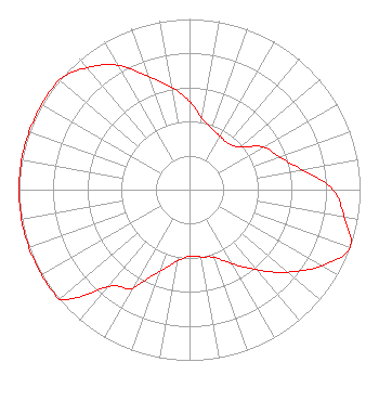 | ||||||||||||||||||
| Azimuth | Ratio | Azimuth | Ratio | Azimuth | Ratio | Azimuth | Ratio | ||||||||||||
| 0 | 0.517 | 10 | 0.422 | 20 | 0.382 | 30 | 0.360 | ||||||||||||
| 40 | 0.354 | 50 | 0.387 | 60 | 0.499 | 70 | 0.560 | ||||||||||||
| 80 | 0.670 | 90 | 0.841 | 100 | 0.921 | 110 | 1.000 | ||||||||||||
| 120 | 0.893 | 130 | 0.752 | 140 | 0.612 | 150 | 0.500 | ||||||||||||
| 160 | 0.423 | 170 | 0.400 | 180 | 0.390 | 190 | 0.425 | ||||||||||||
| 200 | 0.507 | 205 | 0.570 | 210 | 0.670 | 220 | 0.740 | ||||||||||||
| 230 | 1.000 | 240 | 1.000 | 250 | 1.000 | 260 | 1.000 | ||||||||||||
| 270 | 1.000 | 280 | 1.000 | 290 | 1.000 | 300 | 1.000 | ||||||||||||
| 310 | 1.000 | 320 | 0.934 | 330 | 0.842 | 340 | 0.703 | ||||||||||||
| 350 | 0.611 | ||||||||||||||||||
Structure Registration Number 1208601 [ASR Heights Differ from WKJD Application] Structure Type: GTOWER Registered To: American Towers LLC. Structure Address: 3095 W Carr Hill Rd. (204216) Columbus, IN County Name: Bartholomew County ASR Issued: 02/07/2019 Date Built: 08/31/2000 Site Elevation: 212.1 m (696 ft.) Structure Height: 99.1 m (325 ft.) Height Overall: 100.9 m (331 ft.) Overall Height AMSL: 313 m (1027 ft.) FAA Determination: 01/29/2019 FAA Study #: 2018-AGL-21497-OE FAA Circular #: 70/7460-1L Paint & Light FAA Chapters: 4, 8, 12 OM&L to remain the same as prior study = A MED-DUAL SYSTEM 39-11-10.6 N 85-57-28.7 W (NAD 83) 39-11-10.4 N 85-57-28.7 W (Converted to NAD 27) |
825 Washington St Columbus, IN 47201 Phone: 812-379-1077 Not-for-Profit | Date: 10/06/2010 Application Certifier GOOD SHEPHERD RADIO, INC. 825 Washington Street Columbus, IN 47201 Applicant KEITH REISING 1680 Hwy 62 Ne Corydon, NC 47112 CONSULANT LEE J. PELTZMAN Shainis & Peltzman, Chartered | |||||||||||||||||
| |||||||||||||||||||