
FCCInfo.com
A Service of Cavell, Mertz & Associates, Inc.
(855) FCC-INFO
|
|
|
|
|
||||||||||||||||
|
|
WNGU Channel: 208A 89.5 MHz Dahlonega, Georgia Service: FM - A full-service FM station or application. Facility ID: 76477 Fac. Service: FM Analog & Digital Status: License Application Accepted: 09/20/2001 Application Granted: 09/21/2001 File Number: BLED-19980915AAA License Expires: 00/00/0000 Prefix Type: This is a license for a noncommercial educational FM station Application Type: License To Cover FCC Website Links: LMS Facility Details This Application CDBS Application Other WNGU Applications Other WNGU Applications in CDBS Including Superseded Applications Mailing Address Correspondence for WNGU Correspondence related to application BLED-19980915AAA Service Contour - Open Street Map or USGS Map (60 dBu) Service Contour - KML / Google Earth (60 dBu) Public Inspection Files Facility Type: NON-COMMERCIAL EDUC. FM Class: A, A Zone I; I-A; or II station; with 0.1kW-6kW ERP and a class contour distance <=28km Site Location: 34-31-29.3 N 83-59-49.7 W (NAD 83) Site Location: 34-31-29.0 N 83-59-50.0 W (Converted to NAD 27) Effective Radiated Power: 0.75 kW Transmitter Output Power: 0.44 kW Antenna Center HAAT: 140 m (459 ft.) Antenna Center AMSL: 573 m (1880 ft.) Antenna Center HAG: 133 m (436 ft.) Site Elevation: 440 m. (1444 ft.) Height Overall*: 152 m (499 ft.) (* As Filed In This Application, may differ from ASR Data, Below.) Directional Antenna Antenna Make/Model: None Jampro JSLP-2DA, 2 section Antenna ID: 14798 Polarization: | ||||||||||||||||||
| Antenna Data for Antenna Id: 14798 WNGU FM File: BLED-19980915AAA None - Jampro JSLP-2DA, 2 section Service: FM | 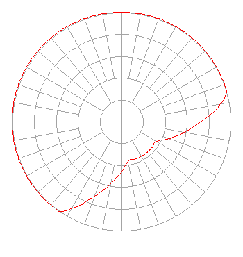 | ||||||||||||||||||
| Azimuth | Ratio | Azimuth | Ratio | Azimuth | Ratio | Azimuth | Ratio | ||||||||||||
| 0 | 1.000 | 10 | 1.000 | 20 | 1.000 | 30 | 1.000 | ||||||||||||
| 40 | 1.000 | 50 | 1.000 | 60 | 1.000 | 70 | 1.000 | ||||||||||||
| 74 | 1.000 | 80 | 0.918 | 90 | 0.729 | 100 | 0.579 | ||||||||||||
| 110 | 0.460 | 120 | 0.366 | 130 | 0.366 | 140 | 0.366 | ||||||||||||
| 150 | 0.366 | 160 | 0.366 | 170 | 0.366 | 180 | 0.460 | ||||||||||||
| 190 | 0.579 | 200 | 0.729 | 210 | 0.918 | 215 | 1.000 | ||||||||||||
| 220 | 1.000 | 230 | 1.000 | 240 | 1.000 | 250 | 1.000 | ||||||||||||
| 260 | 1.000 | 270 | 1.000 | 280 | 1.000 | 290 | 1.000 | ||||||||||||
| 300 | 1.000 | 310 | 1.000 | 320 | 1.000 | 330 | 1.000 | ||||||||||||
| 340 | 1.000 | 350 | 1.000 | ||||||||||||||||
Structure Registration Number 1019716 Structure Type: TOWER Registered To: Crown Castle South LLC Structure Address: Barlow Road And Route 9 Dahlonega, GA County Name: Lumpkin County ASR Issued: 05/06/2016 Date Built: 03/21/1995 Site Elevation: 440.1 m (1444 ft.) Structure Height: 148.1 m (486 ft.) Height Overall: 152.1 m (499 ft.) Overall Height AMSL: 592.2 m (1943 ft.) FAA Determination: 08/23/2008 FAA Study #: 2008-ASO-4354-OE FAA Circular #: 70/7460-1K Paint & Light FAA Chapters: 4, 6, 12 PRIOR STUDY 2004-ASO-27-OE 34-31-29.0 N 83-59-50.0 W (NAD 83) 34-31-28.7 N 83-59-50.3 W (Converted to NAD 27) |
260 14th St Nw Atlanta, GA 30318-5360 Phone: 404-685-2410 Government Entity | Date: 09/15/1998 Application Certifier GEORGIA PUBLIC TELECOMMUNICATIONS COMMISSION 260 14th Street, N.w Atlanta, GA 30318 Applicant TECHNICAL DIRECTOR | |||||||||||||||||