
FCCInfo.com
A Service of Cavell, Mertz & Associates, Inc.
(855) FCC-INFO
|
|
WZUU from 03/29/1995 WZUU from 01/09/1990 |
|  |
|
|||||||||||||||
|
|
WZUU Channel: 223A 92.5 MHz Mattawan, Michigan Service: FM - A full-service FM station or application. Facility ID: 42034 Fac. Service: FM Status: License 73.215 Station Application Accepted: 12/15/2011 Application Granted: 12/20/2011 File Number: BLH-20111215ACH License Expires: 00/00/0000 Prefix Type: This is a license for a commercial FM station Application Type: License To Cover FCC Website Links: LMS Facility Details This Application CDBS Application Other WZUU Applications Other WZUU Applications in CDBS Including Superseded Applications Mailing Address Correspondence for WZUU Correspondence related to application BLH-20111215ACH Service Contour - Open Street Map or USGS Map (60 dBu) Service Contour - KML / Google Earth (60 dBu) Public Inspection Files Facility Type: FM STATION Class: A, A Zone I; I-A; or II station; with 0.1kW-6kW ERP and a class contour distance <=28km Site Location: 42-15-19.1 N 85-40-58.0 W (NAD 83) Site Location: 42-15-19.0 N 85-40-58.0 W (Converted to NAD 27) Effective Radiated Power: 4.7 kW Transmitter Output Power: 3.266 kW Antenna Center HAAT: 111 m (364 ft.) Antenna Center AMSL: 375 m (1230 ft.) Antenna Center HAG: 81 m (266 ft.) Calculated Site Elevation: 294 m. (965 ft.) Height Overall*: 84.8 m (278 ft.) (* As Filed In This Application, may differ from ASR Data, Below.) Directional Antenna Antenna Make/Model: None Dielectric DCRM2EP, 2 section Antenna ID: 102767 Polarization: | ||||||||||||||||||
| Antenna Data for Antenna Id: 102767 WZUU FM File: BLH-20111215ACH None - Dielectric DCRM2EP, 2 section Service: FM | 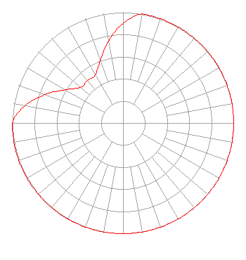 | ||||||||||||||||||
| Azimuth | Ratio | Azimuth | Ratio | Azimuth | Ratio | Azimuth | Ratio | ||||||||||||
| 0 | 0.900 | 10 | 1.000 | 20 | 1.000 | 30 | 1.000 | ||||||||||||
| 40 | 1.000 | 50 | 1.000 | 60 | 1.000 | 70 | 1.000 | ||||||||||||
| 80 | 1.000 | 90 | 1.000 | 100 | 1.000 | 110 | 1.000 | ||||||||||||
| 120 | 1.000 | 130 | 1.000 | 140 | 1.000 | 150 | 1.000 | ||||||||||||
| 160 | 1.000 | 170 | 1.000 | 180 | 1.000 | 190 | 1.000 | ||||||||||||
| 200 | 1.000 | 210 | 1.000 | 220 | 1.000 | 230 | 1.000 | ||||||||||||
| 240 | 1.000 | 250 | 1.000 | 260 | 1.000 | 270 | 1.000 | ||||||||||||
| 280 | 0.900 | 290 | 0.750 | 300 | 0.600 | 310 | 0.500 | ||||||||||||
| 320 | 0.500 | 330 | 0.500 | 340 | 0.600 | 350 | 0.750 | ||||||||||||
Structure Registration Number 1007711 Structure Type: TOWER Registered To: SWI Funds Tower Holdings, LLC Structure Address: 6827 Stadium Drive Kalamazoo, MI County Name: Kalamazoo County ASR Issued: 01/22/2024 Date Built: 11/27/2011 Site Elevation: 294.2 m (965 ft.) Structure Height: 84.8 m (278 ft.) Height Overall: 84.8 m (278 ft.) Overall Height AMSL: 379 m (1243 ft.) FAA Determination: 10/21/2010 FAA Study #: 2010-AGL-5981-OE FAA Circular #: 70/7460-1J Paint & Light FAA Chapters: 3, 4, 5, 13 PRIOR STUDY 1997-AGL-1173-OE 42-15-19.0 N 85-40-58.0 W (NAD 83) 42-15-18.9 N 85-40-58.0 W (Converted to NAD 27) |
P.o. Box 80 Otsego, MI 49078 Phone: 269-692-6851 Corporation | Date: 12/15/2011 Application Certifier FORUM COMMUNICATIONS, INC. P.o. Box 80 Otsego, MI 49078 Applicant WALKER SISSON 2507 University Ave. Kalamazoo, MI 49008 TECHNICAL CONSULTANT MATTHEW H. MCCORMICK, ESQ. Fletcher, Heald & Hildreth, Plc | |||||||||||||||||
|
| ||||||||||||||||||