
FCCInfo.com
A Service of Cavell, Mertz & Associates, Inc.
(855) FCC-INFO
|
|
|
|
|
||||||||||||||||
|
|
KMUW Channel: 206C1 89.1 MHz Wichita, Kansas Service: FM - A full-service FM station or application. Facility ID: 72364 Fac. Service: FM Analog & Digital Status: License Application Accepted: 09/07/2010 Application Granted: 10/19/2010 File Number: BMLED-20100907AAZ License Expires: 00/00/0000 Prefix Type: This is a modification of license for a noncommercial educational FM station Application Type: Minor Modification FCC Website Links: LMS Facility Details This Application CDBS Application Other KMUW Applications Other KMUW Applications in CDBS Including Superseded Applications Mailing Address Correspondence for KMUW Correspondence related to application BMLED-20100907AAZ Service Contour - Open Street Map or USGS Map (60 dBu) Service Contour - KML / Google Earth (60 dBu) Public Inspection Files History Cards for KMUW Facility Type: NON-COMMERCIAL EDUC. FM Class: C1, A Zone II station; with 50kW-100kW ERP and a class contour distance 52km-72km Site Location: 37-46-26.0 N 97-30-53.0 W (NAD 83) Site Location: 37-46-26.0 N 97-30-51.8 W (Converted to NAD 27) Effective Radiated Power: 100 kW Transmitter Output Power: 24.1 kW Antenna Center HAAT: 277.6 m (911 ft.) Antenna Center AMSL: 698.6 m (2292 ft.) Antenna Center HAG: 281.9 m (925 ft.) Site Elevation: 416.7 m. (1367 ft.) Height Overall*: 326.4 m (1071 ft.) (* As Filed In This Application, may differ from ASR Data, Below.) Directional Antenna Antenna Make/Model: Electronics Research Inc. MP-6C-DA Antenna ID: 77193 Polarization: | ||||||||||||||||||
| Antenna Data for Antenna Id: 77193 KMUW FM File: BMLED-20100907AAZ Electronics Research Inc. - MP-6C-DA Service: FM | 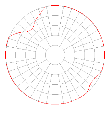 | ||||||||||||||||||
| Azimuth | Ratio | Azimuth | Ratio | Azimuth | Ratio | Azimuth | Ratio | ||||||||||||
| 0 | 1.000 | 10 | 1.000 | 20 | 1.000 | 30 | 1.000 | ||||||||||||
| 40 | 1.000 | 50 | 1.000 | 60 | 1.000 | 70 | 1.000 | ||||||||||||
| 80 | 1.000 | 90 | 1.000 | 100 | 1.000 | 110 | 0.990 | ||||||||||||
| 120 | 0.936 | 130 | 0.930 | 140 | 1.000 | 150 | 1.000 | ||||||||||||
| 160 | 1.000 | 170 | 1.000 | 180 | 1.000 | 190 | 1.000 | ||||||||||||
| 200 | 1.000 | 210 | 1.000 | 220 | 1.000 | 230 | 1.000 | ||||||||||||
| 240 | 1.000 | 250 | 1.000 | 260 | 1.000 | 270 | 1.000 | ||||||||||||
| 280 | 1.000 | 290 | 1.000 | 300 | 0.881 | 310 | 0.733 | ||||||||||||
| 320 | 0.701 | 330 | 0.795 | 340 | 0.882 | 350 | 1.000 | ||||||||||||
Structure Registration Number 1244913 Structure Type: GTOWER Registered To: Nexstar Media Inc. Structure Address: 504 North 151 Street West Wichita, KS County Name: Sedgwick County ASR Issued: 11/19/2021 Date Built: 08/27/2004 Site Elevation: 416.7 m (1367 ft.) Structure Height: 310.7 m (1019 ft.) Height Overall: 326.4 m (1071 ft.) Overall Height AMSL: 743.1 m (2438 ft.) FAA Determination: 11/17/2021 FAA Study #: 2021-ACE-5516-OE FAA Circular #: 70/7460-1M Paint & Light FAA Chapters: 4, 9, 15 PRIOR STUDY 2004-ACE-1180-OE 37-46-25.0 N 97-30-54.6 W (NAD 83) 37-46-25.0 N 97-30-53.4 W (Converted to NAD 27) |
121 North Mead Street Suite 200 Wichita, KS 67202 Phone: 316-978-7191 Government Entity | Date: 09/07/2010 Application Certifier WICHITA STATE UNIVERSITY 3317 East 17th Street, North Wichita, KS 67208-1912 Applicant WILLIAM H. NOLAN 1632 S. Maize Road Wichita, KS 67209-3912 CONSULTING ENGINEER MALCOLM G. STEVENSON Schwartz, Woods & Miller | |||||||||||||||||