
FCCInfo.com
A Service of Cavell, Mertz & Associates, Inc.
(855) FCC-INFO
|
|
W297BH from 04/07/2004 |
|
|
||||||||||||||||
|
|
W297BH Channel: 297D 107.3 MHz Suffolk, Virginia Service: FX - A translator or application for a translator. Facility ID: 155036 Fac. Service: FX Programming Delivery Method: Unspecified Status: License Application Accepted: 01/31/2012 Application Granted: 02/10/2012 File Number: BLFT-20120131ACU License Expires: 00/00/0000 Prefix Type: This is a license for a translator Application Type: License To Cover FCC Website Links: LMS Facility Details This Application CDBS Application Other W297BH Applications Other W297BH Applications in CDBS Including Superseded Applications Mailing Address Correspondence for W297BH Correspondence related to application BLFT-20120131ACU Service Contour - Open Street Map or USGS Map (60 dBu) Service Contour - KML / Google Earth (60 dBu) Class: D, A Noncommercial educational operating with no more than 10W Site Location: 36-48-32.5 N 76-30-11.8 W (NAD 83) Site Location: 36-48-32.0 N 76-30-13.0 W (Converted to NAD 27) Effective Radiated Power: 0.25 kW Transmitter Output Power: 0.82 kW Antenna Center HAAT: 145.3 m Horiz.; 0 m Vert. Antenna Center AMSL: 150 m (492 ft.) Antenna Center HAG: 143 m (469 ft.) Site Elevation: 7 m. (23 ft.) Height Overall*: 194 m (636 ft.) (* As Filed In This Application, may differ from ASR Data, Below.) Directional Antenna Antenna Make/Model: None Antenna ID: 107311 Polarization:
| ||||||||||||||||||
| Antenna Data for Antenna Id: 107311 W297BH FX File: BLFT-20120131ACU None - Service: FX Pattern and Field Values Include a 120° Clockwise Rotation | 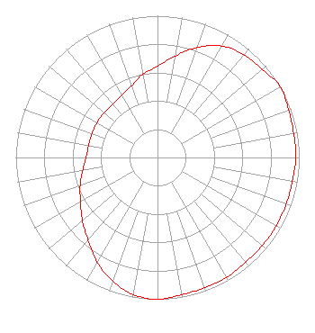 | ||||||||||||||||||
| Azimuth | Ratio | Azimuth | Ratio | Azimuth | Ratio | Azimuth | Ratio | ||||||||||||
| 0 | 0.643 | 10 | 0.728 | 20 | 0.826 | 30 | 0.908 | ||||||||||||
| 40 | 0.947 | 50 | 0.966 | 60 | 1.000 | 70 | 0.984 | ||||||||||||
| 80 | 0.976 | 90 | 0.976 | 100 | 0.966 | 110 | 0.966 | ||||||||||||
| 120 | 0.966 | 130 | 0.966 | 140 | 0.966 | 150 | 0.976 | ||||||||||||
| 160 | 0.976 | 170 | 0.984 | 180 | 1.000 | 190 | 0.982 | ||||||||||||
| 200 | 0.927 | 210 | 0.852 | 220 | 0.762 | 230 | 0.692 | ||||||||||||
| 240 | 0.627 | 250 | 0.581 | 260 | 0.536 | 270 | 0.504 | ||||||||||||
| 280 | 0.493 | 290 | 0.493 | 300 | 0.493 | 310 | 0.493 | ||||||||||||
| 320 | 0.492 | 330 | 0.507 | 340 | 0.536 | 350 | 0.596 | ||||||||||||
Structure Registration Number 1027474 [ASR Heights Differ from W297BH Application] Structure Type: GTOWER Registered To: American Towers LLC Structure Address: 3702b Nansemond Pky (010192) Suffolk, VA County Name: Suffolk city ASR Issued: 10/31/2022 Date Built: 06/27/2010 Site Elevation: 7 m (23 ft.) Structure Height: 192 m (630 ft.) Height Overall: 193.5 m (635 ft.) Overall Height AMSL: 200.5 m (658 ft.) FAA Determination: 10/19/2022 FAA Study #: 2021-AEA-16703-OE Paint & Light FAA Chapters: NONE PRIOR STUDY 2010-AEA-2732-OE 36-48-32.5 N 76-30-11.3 W (NAD 83) 36-48-32.0 N 76-30-12.5 W (Converted to NAD 27) |
1971 Universtiy Boulevard Lynchburg, VA 24502-2269 Phone: 434-582-2722 | Date: 01/31/2012 Application Certifier LIBERTY UNIVERSITY, INC. 1971 University Boulevard Lynchburg, VA 24502-2269 Applicant ROBERT H BRANCH JR 212 Honey Tree Lane Lynchburg, VA 24502 TECHNICAL CONSULTANT HARRY C. MARTIN Fletcher, Heald & Hildreth, Plc 1300 North 17th Street 11th Floor Arlington, VA 22209 | |||||||||||||||||