
FCCInfo.com
A Service of Cavell, Mertz & Associates, Inc.
(855) FCC-INFO
|
|
W254CN from 10/31/2013 |
|
|
||||||||||||||||
|
|
W254CN Channel: 254D 98.7 MHz Eau Claire, Wisconsin Service: FX - A translator or application for a translator. Facility ID: 138368 Fac. Service: FX Programming Delivery Method: Unspecified Status: License Application Accepted: 07/15/2016 Application Granted: 07/25/2016 File Number: BLFT-20160715AAC License Expires: 00/00/0000 Prefix Type: This is a license for a translator Application Type: License To Cover FCC Website Links: LMS Facility Details This Application CDBS Application Other W254CN Applications Other W254CN Applications in CDBS Including Superseded Applications Mailing Address Correspondence for W254CN Correspondence related to application BLFT-20160715AAC Service Contour - Open Street Map or USGS Map (60 dBu) Service Contour - KML / Google Earth (60 dBu) Class: D, A Noncommercial educational operating with no more than 10W Site Location: 44-47-60.0 N 91-27-57.0 W (NAD 83) Site Location: 44-48-00.1 N 91-27-56.4 W (Converted to NAD 27) Effective Radiated Power: 0 kW Horiz. ; 0.25 kW Vert. Transmitter Output Power: 0.566 kW Antenna Center HAAT: 0 m Antenna Center AMSL: 0 m Horiz.; 518 m Vert. Antenna Center HAG: 0 m Horiz.; 247 m Vert. Site Elevation: 271 m. (889 ft.) Height Overall*: 293 m (961 ft.) (* As Filed In This Application, may differ from ASR Data, Below.) Directional Antenna Antenna Make/Model: None Antenna ID: 61047 Polarization:
| ||||||||||||||||||
| Antenna Data for Antenna Id: 61047 W254CN FX File: BLFT-20160715AAC None - Service: FX Pattern and Field Values Include a 295° Clockwise Rotation | 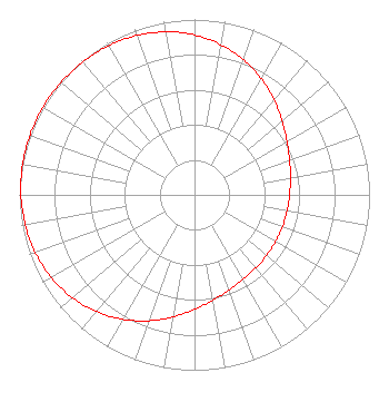 | ||||||||||||||||||
| Azimuth | Ratio | Azimuth | Ratio | Azimuth | Ratio | Azimuth | Ratio | ||||||||||||
| 5 | 0.892 | 15 | 0.845 | 25 | 0.792 | 35 | 0.735 | ||||||||||||
| 45 | 0.679 | 55 | 0.630 | 65 | 0.592 | 75 | 0.566 | ||||||||||||
| 85 | 0.549 | 95 | 0.540 | 105 | 0.535 | 115 | 0.534 | ||||||||||||
| 125 | 0.535 | 135 | 0.540 | 145 | 0.549 | 155 | 0.566 | ||||||||||||
| 165 | 0.592 | 175 | 0.630 | 185 | 0.679 | 195 | 0.735 | ||||||||||||
| 205 | 0.792 | 215 | 0.845 | 225 | 0.892 | 235 | 0.929 | ||||||||||||
| 245 | 0.956 | 255 | 0.975 | 265 | 0.987 | 275 | 0.995 | ||||||||||||
| 285 | 0.999 | 295 | 1.000 | 305 | 0.999 | 315 | 0.995 | ||||||||||||
| 325 | 0.987 | 335 | 0.975 | 345 | 0.956 | 355 | 0.929 | ||||||||||||
Structure Registration Number 1033663 Structure Type: TOWER Registered To: Gray Media Group, Inc. Structure Address: 1907 S Hastings Way Eau Claire, WI County Name: Eau Claire County ASR Issued: 09/09/2020 Date Built: 09/25/1956 Site Elevation: 270.9 m (889 ft.) Structure Height: 270.7 m (888 ft.) Height Overall: 293 m (961 ft.) Overall Height AMSL: 563.9 m (1850 ft.) FAA Determination: 08/03/1998 FAA Study #: 98-AGL-0904-OE Paint & Light FAA Chapters: 1, 3, 7, 16, 21 OM&L TO CONTINUE AS RED LIGHTS/PAINT AS PER PRIOR FAA 78-GL-0234-OE. 44-48-00.0 N 91-27-57.0 W (NAD 83) 44-48-00.1 N 91-27-56.4 W (Converted to NAD 27) |
7136 S. Yale Avenue Suite 501 Tulsa, OK 74136 Phone: 918-664-4581 | Date: 07/15/2016 Application Certifier AMFM RADIO LICENSES, LLC 2625 S. Memorial Drive Suite A Tulsa, OK 74129-2623 Applicant TROY G LANGHAM 2625 S Memorial Drive Suite A Tulsa, OK 74129 FCC ENGINEERING SUPERVISOR TROY LANGHAM Iheartmedia, Inc. 2625 S. Memorial Drive Suite A Tulsa, OK 74129-2623 | |||||||||||||||||