
FCCInfo.com
A Service of Cavell, Mertz & Associates, Inc.
(855) FCC-INFO
|
|
WILV from 11/16/1987 |
|
|
||||||||||||||||
|
|
WILV Channel: 216B1 91.1 MHz Loves Park, Illinois Service: FM - A full-service FM station or application. Facility ID: 11064 Fac. Service: FM Status: License Application Accepted: 07/27/2001 Application Granted: 11/15/2001 File Number: BLED-20010727AAW License Expires: 00/00/0000 Prefix Type: This is a license for a noncommercial educational FM station Application Type: License To Cover FCC Website Links: LMS Facility Details This Application CDBS Application Other WILV Applications Other WILV Applications in CDBS Including Superseded Applications Mailing Address Correspondence for WILV Correspondence related to application BLED-20010727AAW Service Contour - Open Street Map or USGS Map (60 dBu) Service Contour - KML / Google Earth (60 dBu) Public Inspection Files Facility Type: NON-COMMERCIAL EDUC. FM Class: B1, A Zone I or I-A station; with 6kW-25kW ERP and a class contour distance 28km-39km Site Location: 42-19-20.1 N 89-00-41.4 W (NAD 83) Site Location: 42-19-20.0 N 89-00-41.0 W (Converted to NAD 27) Effective Radiated Power: 7 kW Transmitter Output Power: 2.68 kW Antenna Center HAAT: 161 m (528 ft.) Antenna Center AMSL: 408 m (1339 ft.) Antenna Center HAG: 147 m (482 ft.) Calculated Site Elevation: 261 m. (856 ft.) Height Overall*: 152 m (499 ft.) (* As Filed In This Application, may differ from ASR Data, Below.) Directional Antenna Antenna Make/Model: Electronics Research Inc. LP-4E-DA Antenna ID: 15554 Polarization:
| ||||||||||||||||||
| Antenna Data for Antenna Id: 15554 WILV FM File: BLED-20010727AAW Electronics Research Inc. - LP-4E-DA Service: FM | 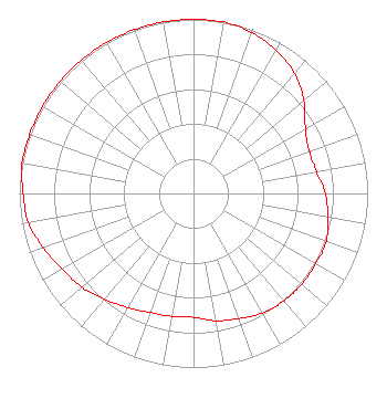 | ||||||||||||||||||
| Azimuth | Ratio | Azimuth | Ratio | Azimuth | Ratio | Azimuth | Ratio | ||||||||||||
| 0 | 1.000 | 10 | 1.000 | 20 | 0.982 | 30 | 0.949 | ||||||||||||
| 40 | 0.902 | 50 | 0.828 | 60 | 0.742 | 70 | 0.707 | ||||||||||||
| 80 | 0.717 | 90 | 0.756 | 100 | 0.784 | 110 | 0.811 | ||||||||||||
| 120 | 0.811 | 130 | 0.811 | 140 | 0.806 | 150 | 0.793 | ||||||||||||
| 160 | 0.765 | 170 | 0.742 | 180 | 0.712 | 190 | 0.717 | ||||||||||||
| 200 | 0.727 | 210 | 0.756 | 220 | 0.793 | 230 | 0.837 | ||||||||||||
| 240 | 0.870 | 250 | 0.918 | 260 | 0.964 | 270 | 0.978 | ||||||||||||
| 280 | 1.000 | 290 | 1.000 | 300 | 1.000 | 310 | 1.000 | ||||||||||||
| 320 | 1.000 | 330 | 1.000 | 340 | 1.000 | 350 | 1.000 | ||||||||||||
Structure Registration Number 1013171 Structure Type: GTOWER Registered To: Global Tower, LLC. through American Towers, LLC Structure Address: 5375 Pebble Creek Trail (371253) Loves Park, IL County Name: Winnebago County ASR Issued: 11/20/2017 Date Built: 04/09/1998 Site Elevation: 260.9 m (856 ft.) Structure Height: 151.8 m (498 ft.) Height Overall: 152.4 m (500 ft.) Overall Height AMSL: 413.3 m (1356 ft.) FAA Determination: 11/15/2017 FAA Study #: 2017-AGL-19954-OE FAA Circular #: 70/7460-1L Paint & Light FAA Chapters: 4, 8, 12 PRIOR STUDY 1998-AGL-659-OE 42-19-20.0 N 89-00-41.4 W (NAD 83) 42-19-19.9 N 89-00-41.0 W (Converted to NAD 27) |
5700 West Oaks Blvd Rocklin, CA 95765 Phone: 916-251-1600 Not-for-Profit | Date: 07/27/2001 Application Certifier CHRISTIAN LIFE CENTER SCHOOL 5375 Pebble Creek Trail Loves Park, IL 61111 Applicant JON BURKHOLDER P.o. Box 2730 Rockford, IL 61132-2730 BROADCAST ENGINEER | |||||||||||||||||