
FCCInfo.com
A Service of Cavell, Mertz & Associates, Inc.
(855) FCC-INFO
|
|
W290AD from 10/20/1988 |
|
|
||||||||||||||||
|
|
W290AD Channel: 290D 105.9 MHz Southern Pines, North Carolina Service: FX - A translator or application for a translator. Facility ID: 5128 Fac. Service: FX Programming Delivery Method: Unspecified Status: License Application Accepted: 10/11/2016 Application Granted: 10/24/2016 File Number: BLFT-20161011AEH License Expires: 00/00/0000 Prefix Type: This is a license for a translator Application Type: License To Cover FCC Website Links: LMS Facility Details This Application CDBS Application Other W290AD Applications Other W290AD Applications in CDBS Including Superseded Applications Mailing Address Correspondence for W290AD Correspondence related to application BLFT-20161011AEH Service Contour - Open Street Map or USGS Map (60 dBu) Service Contour - KML / Google Earth (60 dBu) Class: D, A Noncommercial educational operating with no more than 10W Site Location: 35-11-46.6 N 79-24-45.1 W (NAD 83) Site Location: 35-11-46.0 N 79-24-46.0 W (Converted to NAD 27) Effective Radiated Power: 0.046 kW Transmitter Output Power: 0.142 kW Antenna Center HAAT: 0 m Antenna Center AMSL: 206 m (676 ft.) Antenna Center HAG: 55 m (180 ft.) Site Elevation: 151 m. (495 ft.) Height Overall*: 73 m (240 ft.) (* As Filed In This Application, may differ from ASR Data, Below.) Directional Antenna Antenna Make/Model: None Antenna ID: 125604 Polarization:
| ||||||||||||||||||
| Antenna Data for Antenna Id: 125604 W290AD FX File: BLFT-20161011AEH None - Service: FX | 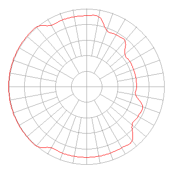 | ||||||||||||||||||
| Azimuth | Ratio | Azimuth | Ratio | Azimuth | Ratio | Azimuth | Ratio | ||||||||||||
| 0 | 0.909 | 10 | 0.909 | 20 | 0.766 | 30 | 0.766 | ||||||||||||
| 40 | 0.766 | 50 | 0.643 | 60 | 0.643 | 70 | 0.643 | ||||||||||||
| 80 | 0.643 | 90 | 0.643 | 100 | 0.643 | 110 | 0.766 | ||||||||||||
| 120 | 0.766 | 130 | 0.766 | 140 | 0.909 | 150 | 0.909 | ||||||||||||
| 160 | 0.909 | 170 | 0.909 | 180 | 0.909 | 190 | 0.909 | ||||||||||||
| 200 | 0.909 | 210 | 0.909 | 220 | 1.000 | 230 | 1.000 | ||||||||||||
| 240 | 1.000 | 250 | 1.000 | 260 | 1.000 | 270 | 1.000 | ||||||||||||
| 280 | 1.000 | 290 | 1.000 | 300 | 1.000 | 310 | 1.000 | ||||||||||||
| 320 | 1.000 | 330 | 0.909 | 340 | 0.909 | 350 | 0.909 | ||||||||||||
Structure Registration Number 1007956 Structure Type: LTOWER Registered To: Diamond Towers IV LLC Structure Address: 1300 Midland Rd Southern Pines, NC County Name: Moore County ASR Issued: 09/21/2022 Date Built: 01/01/1947 Site Elevation: 151.4 m (497 ft.) Structure Height: 73.1 m (240 ft.) Height Overall: 73.1 m (240 ft.) Overall Height AMSL: 224.5 m (737 ft.) FAA Determination: 04/12/2016 FAA Study #: 2016-ASO-1610-OE Paint & Light FAA Chapters: 1, 3, 11, 21 Continue As Is OM&L = PAINT/RED LIGHTS 35-11-46.8 N 79-24-44.7 W (NAD 83) 35-11-46.2 N 79-24-45.6 W (Converted to NAD 27) |
11530 Carmel Commons Blvd Charlotte, NC 28226-3976 Phone: 704-523-5555 | Date: 10/11/2016 Application Certifier BIBLE BROADCASTING NETWORK, INC. 11530 Carmel Commons Boulevard Charlotte, NC 28226 Applicant JUSTIN W. ASHER Munn-reese P.o. Box 220 Coldwater, MI 49036-0220 CONSULTING ENGINEER GARY S. SMITHWICK Smithwick & Belendiuk, P.c. 5028 Wisconsin Avenue, Nw Suite 301 Washington, DC 20016 | |||||||||||||||||