
FCCInfo.com
A Service of Cavell, Mertz & Associates, Inc.
(855) FCC-INFO
|
|
K220KC from 09/15/2008 |
|
|
||||||||||||||||
|
|
K220KC Channel: 220D 91.9 MHz Huntsville, Texas Service: FX - A translator or application for a translator. Facility ID: 122923 Fac. Service: FX Programming Delivery Method: Unspecified Status: License Application Accepted: 10/23/2014 Application Granted: 11/24/2014 File Number: BLFT-20141023AAN License Expires: 00/00/0000 Prefix Type: This is a license for a translator Application Type: License To Cover FCC Website Links: LMS Facility Details This Application CDBS Application Other K220KC Applications Other K220KC Applications in CDBS Including Superseded Applications Mailing Address Correspondence for K220KC Correspondence related to application BLFT-20141023AAN Service Contour - Open Street Map or USGS Map (60 dBu) Service Contour - KML / Google Earth (60 dBu) Class: D, A Noncommercial educational operating with no more than 10W Site Location: 30-41-38.1 N 95-31-21.5 W (NAD 83) Site Location: 30-41-37.4 N 95-31-20.7 W (Converted to NAD 27) Effective Radiated Power: 0 kW Horiz. ; 0.11 kW Vert. Transmitter Output Power: 0.31 kW Antenna Center HAAT: 0 m Antenna Center AMSL: 0 m Horiz.; 196 m Vert. Antenna Center HAG: 0 m Horiz.; 59 m Vert. Site Elevation: 137 m. (449 ft.) Height Overall*: 101 m (331 ft.) (* As Filed In This Application, may differ from ASR Data, Below.) Directional Antenna Antenna Make/Model: None Antenna ID: 119439 Polarization:
| ||||||||||||||||||
| Antenna Data for Antenna Id: 119439 K220KC FX File: BLFT-20141023AAN None - Service: FX | 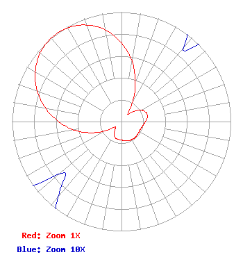 | ||||||||||||||||||
| Azimuth | Ratio | Azimuth | Ratio | Azimuth | Ratio | Azimuth | Ratio | ||||||||||||
| 0 | 0.719 | 10 | 0.557 | 20 | 0.371 | 30 | 0.197 | ||||||||||||
| 40 | 0.088 | 50 | 0.139 | 60 | 0.207 | 70 | 0.241 | ||||||||||||
| 80 | 0.240 | 90 | 0.220 | 100 | 0.200 | 110 | 0.189 | ||||||||||||
| 120 | 0.186 | 130 | 0.188 | 140 | 0.192 | 150 | 0.189 | ||||||||||||
| 160 | 0.187 | 170 | 0.178 | 180 | 0.169 | 190 | 0.165 | ||||||||||||
| 200 | 0.160 | 210 | 0.138 | 220 | 0.090 | 230 | 0.075 | ||||||||||||
| 240 | 0.170 | 250 | 0.299 | 260 | 0.439 | 270 | 0.576 | ||||||||||||
| 280 | 0.705 | 290 | 0.821 | 300 | 0.911 | 310 | 0.972 | ||||||||||||
| 320 | 0.998 | 330 | 0.989 | 340 | 0.939 | 350 | 0.851 | ||||||||||||
Structure Registration Number 1048518 Structure Type: Registered To: American Towers LLC Structure Address: 510 Graham Rd (huntsville 2 / Graham Rd #4389) Huntsville, TX County Name: Walker County ASR Issued: 06/22/2016 Date Built: 05/18/1998 Site Elevation: 136.8 m (449 ft.) Structure Height: 98.4 m (323 ft.) Height Overall: 101.2 m (332 ft.) Overall Height AMSL: 238 m (781 ft.) FAA Determination: 11/01/2004 FAA Study #: 2004-ASW-5508-OE FAA Circular #: 70/7460-1J Paint & Light FAA Chapters: 4, 8, 13 PRIOR STUDY 2002-ASW-961-OE 30-41-38.1 N 95-31-21.5 W (NAD 83) 30-41-37.4 N 95-31-20.7 W (Converted to NAD 27) |
3729 Cahuenga Blvd. West Los Angeles, CA 91604 Phone: 510-849-2590 | Date: 10/23/2014 Application Certifier PACIFICA FOUNDATION, INC. 1925 Martin Luther King Jr. Way Berkeley, CA 94704 Applicant DONALD E. MUSSELL JR NCE-CBT P.o. Box 983 Kilauea, HI 96754 CONSULTING ENGINEER JOHN CRIGLER, ESQUIRE Garvey Schubert Barer 1000 Potomac St., N.w. 5th Floor Washington, DC 20007-3501 | |||||||||||||||||