
FCCInfo.com
A Service of Cavell, Mertz & Associates, Inc.
(855) FCC-INFO
|
|
W227DC from 08/13/2013 W227DC from 04/10/2013 W227DC from 12/19/2012 W227DC from 12/22/2009 W227DC from 11/18/2009 W227DC from 09/07/2004 |
|
|
||||||||||||||||
|
|
W227DC Channel: 227D 93.3 MHz Nashville, Tennessee Service: FX - A translator or application for a translator. Facility ID: 146836 Fac. Service: FX Programming Delivery Method: Unspecified Status: License Application Accepted: 03/15/2016 Application Granted: 12/07/2016 File Number: BLFT-20160315AAM License Expires: 08/01/2028 Prefix Type: This is a license for a translator Application Type: License To Cover FCC Website Links: LMS Facility Details This Application CDBS Application Other W227DC Applications Other W227DC Applications in CDBS Including Superseded Applications Mailing Address Correspondence for W227DC Correspondence related to application BLFT-20160315AAM Service Contour - Open Street Map or USGS Map (60 dBu) Service Contour - KML / Google Earth (60 dBu) Class: D, A Noncommercial educational operating with no more than 10W Site Location: 36-08-27.2 N 86-51-56.0 W (NAD 83) Site Location: 36-08-27.0 N 86-51-56.0 W (Converted to NAD 27) Effective Radiated Power: 0.25 kW Transmitter Output Power: 0.812 kW Antenna Center HAAT: 0 m Antenna Center AMSL: 418 m (1371 ft.) Antenna Center HAG: 212 m (696 ft.) Site Elevation: 206 m. (676 ft.) Height Overall*: 417 m (1368 ft.) (* As Filed In This Application, may differ from ASR Data, Below.) Directional Antenna Antenna Make/Model: BEXT TFC-2K-2 HW Antenna ID: 123346 Polarization: H
| ||||||||||||||||||
| Antenna Data for Antenna Id: 123346 W227DC FX File: BLFT-20160315AAM BEXT - TFC-2K-2 HW Service: FX | 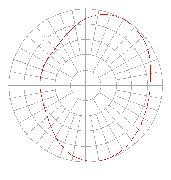 | ||||||||||||||||||
| Azimuth | Ratio | Azimuth | Ratio | Azimuth | Ratio | Azimuth | Ratio | ||||||||||||
| 0 | 0.864 | 10 | 0.932 | 20 | 0.974 | 30 | 0.991 | ||||||||||||
| 40 | 0.985 | 50 | 0.962 | 60 | 0.929 | 70 | 0.893 | ||||||||||||
| 80 | 0.862 | 90 | 0.842 | 100 | 0.837 | 110 | 0.845 | ||||||||||||
| 120 | 0.868 | 130 | 0.901 | 140 | 0.936 | 150 | 0.972 | ||||||||||||
| 160 | 0.994 | 170 | 1.000 | 180 | 0.979 | 190 | 0.935 | ||||||||||||
| 200 | 0.864 | 210 | 0.779 | 220 | 0.702 | 230 | 0.645 | ||||||||||||
| 240 | 0.611 | 250 | 0.596 | 260 | 0.592 | 270 | 0.594 | ||||||||||||
| 280 | 0.596 | 290 | 0.596 | 300 | 0.596 | 310 | 0.601 | ||||||||||||
| 320 | 0.617 | 330 | 0.651 | 340 | 0.707 | 350 | 0.781 | ||||||||||||
Structure Registration Number 1050735 Structure Type: GTOWER Registered To: Gray Media Group, Inc. Structure Address: 5700 Knob Road Nashville, TN County Name: Davidson County ASR Issued: 12/02/2021 Date Built: 01/01/1986 Site Elevation: 205.7 m (675 ft.) Structure Height: 391.4 m (1284 ft.) Height Overall: 417.4 m (1369 ft.) Overall Height AMSL: 623.1 m (2044 ft.) FAA Determination: 01/28/2021 FAA Study #: 2020-ASO-36673-OE FAA Circular #: 70/7460-1M Paint & Light FAA Chapters: 3, 4, 5, 15 PRIOR STUDY 1998-ASO-1912-OE 36-08-27.0 N 86-51-56.0 W (NAD 83) 36-08-26.8 N 86-51-56.0 W (Converted to NAD 27) |
P.o. Box 150846 Nashville, TN 37215 Phone: 615-361-7560 Corporation | Date: 03/15/2016 Application Certifier BAYARD H. WALTERS P.o. Box 150846 Nashville, TN 37215 Applicant CHARLES M. ANDERSON Anderson Associates 1519 Euclid Avenue Bowling Green, KY 42103 CONSULTANT JOHN F. GARZIGLIA Womble Carlyle Sandridge & Rice, Llp 1200 19th Street, N.w. Suite 500 Washington, DC 20036 | |||||||||||||||||