
FCCInfo.com
A Service of Cavell, Mertz & Associates, Inc.
(855) FCC-INFO
|
|
|
|  |
|
|||||||||||||||
|
|
WHFW Channel: 209A 89.7 MHz Winchester, Virginia Service: FM - A full-service FM station or application. Facility ID: 176296 Fac. Service: FM Status: License Application Accepted: 06/21/2013 Application Granted: 07/17/2013 File Number: BLED-20130621AAM License Expires: 00/00/0000 Prefix Type: This is a license for a noncommercial educational FM station Application Type: Amendment FCC Website Links: LMS Facility Details This Application CDBS Application Other WHFW Applications Other WHFW Applications in CDBS Including Superseded Applications Mailing Address Correspondence for WHFW Correspondence related to application BLED-20130621AAM Service Contour - Open Street Map or USGS Map (60 dBu) Service Contour - KML / Google Earth (60 dBu) Public Inspection Files Facility Type: NON-COMMERCIAL EDUC. FM Class: A, A Zone I; I-A; or II station; with 0.1kW-6kW ERP and a class contour distance <=28km Site Location: 39-09-28.1 N 78-06-26.2 W (NAD 83) Site Location: 39-09-27.7 N 78-06-27.2 W (Converted to NAD 27) Effective Radiated Power: 0.185 kW Transmitter Output Power: 0.157 kW Antenna Center HAAT: 53 m (174 ft.) Antenna Center AMSL: 256 m (840 ft.) Antenna Center HAG: 60 m (197 ft.) Calculated Site Elevation: 196 m. (643 ft.) Height Overall*: 82.3 m (270 ft.) (* As Filed In This Application, may differ from ASR Data, Below.) Directional Antenna Antenna Make/Model: Shivley 6810-1R-DA Antenna ID: 113472 Polarization: | ||||||||||||||||||
| Antenna Data for Antenna Id: 113472 WHFW FM File: BLED-20130621AAM Shivley - 6810-1R-DA Service: FM | 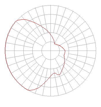 | ||||||||||||||||||
| Azimuth | Ratio | Azimuth | Ratio | Azimuth | Ratio | Azimuth | Ratio | ||||||||||||
| 0 | 0.356 | 10 | 0.283 | 20 | 0.225 | 30 | 0.178 | ||||||||||||
| 40 | 0.178 | 50 | 0.200 | 60 | 0.225 | 70 | 0.252 | ||||||||||||
| 80 | 0.283 | 90 | 0.317 | 100 | 0.317 | 110 | 0.317 | ||||||||||||
| 120 | 0.356 | 130 | 0.400 | 140 | 0.448 | 150 | 0.503 | ||||||||||||
| 160 | 0.563 | 170 | 0.503 | 180 | 0.563 | 190 | 0.708 | ||||||||||||
| 200 | 0.890 | 210 | 1.000 | 220 | 1.000 | 230 | 1.000 | ||||||||||||
| 240 | 1.000 | 250 | 1.000 | 260 | 1.000 | 270 | 1.000 | ||||||||||||
| 280 | 1.000 | 290 | 1.000 | 300 | 1.000 | 310 | 1.000 | ||||||||||||
| 320 | 0.890 | 330 | 0.708 | 340 | 0.563 | 350 | 0.448 | ||||||||||||
Structure Registration Number 1022973 Structure Type: MAST Registered To: American Towers LLC Structure Address: 500 W State R 831 Winchester, VA County Name: Frederick County ASR Issued: 12/25/2019 Date Built: 10/31/1991 Site Elevation: 195.7 m (642 ft.) Structure Height: 81.1 m (266 ft.) Height Overall: 82.3 m (270 ft.) Overall Height AMSL: 278 m (912 ft.) FAA Determination: 06/09/2003 FAA Study #: 2003-AEA-1581-OE FAA Circular #: 70/7460-1K Paint & Light FAA Chapters: 4, 8, 12 OM&L TO REMAIN THE SAME AS PRIOR STUDY = A MED-DUAL SYSTEM 39-09-28.1 N 78-06-26.2 W (NAD 83) 39-09-27.7 N 78-06-27.2 W (Converted to NAD 27) |
134 Christendom Drive Front Royal, VA 22630 Phone: 540-636-2900 | Date: 06/21/2013 Application Certifier HOLY FAMILY COMMUNICATIONS 7009 Ashbury Drive Springfield, VA 22152 Applicant W. PETER DEAL 459 Bakers Ridge Rd Morgantown, WV 26508 CONSULTING ENGINEER STUART W. NOLAN, JR., ESQ. Legalworks Apostolate, Pllc. | |||||||||||||||||