
FCCInfo.com
A Service of Cavell, Mertz & Associates, Inc.
(855) FCC-INFO
|
|
WJYJ from 07/11/1997 WJYJ from 12/27/1984 WJYJ from 11/19/1984 |
|
|
||||||||||||||||
|
|
WJYJ Channel: 201C2 88.1 MHz Hickory, North Carolina Service: FM - A full-service FM station or application. Facility ID: 53091 Fac. Service: FM Status: License Application Accepted: 10/24/2001 Application Granted: 12/04/2001 File Number: BLED-20011024AAG License Expires: 00/00/0000 Prefix Type: This is a license for a noncommercial educational FM station Application Type: License To Cover FCC Website Links: LMS Facility Details This Application CDBS Application Other WJYJ Applications Other WJYJ Applications in CDBS Including Superseded Applications Mailing Address Correspondence for WJYJ Correspondence related to application BLED-20011024AAG Service Contour - Open Street Map or USGS Map (60 dBu) Service Contour - KML / Google Earth (60 dBu) Public Inspection Files Facility Type: NON-COMMERCIAL EDUC. FM Class: C2, A Zone II station; with 25kW-50kW ERP and a class contour distance 39km-52km Site Location: 35-43-34.5 N 81-08-51.3 W (NAD 83) Site Location: 35-43-34.0 N 81-08-52.0 W (Converted to NAD 27) Effective Radiated Power: 26.5 kW Horiz. ; 21 kW Vert. Transmitter Output Power: 8.2 kW Antenna Center HAAT: 77 m (253 ft.) Antenna Center AMSL: 372 m (1220 ft.) Antenna Center HAG: 85 m (279 ft.) Calculated Site Elevation: 287 m. (942 ft.) Height Overall*: 91 m (299 ft.) (* As Filed In This Application, may differ from ASR Data, Below.) Directional Antenna Antenna Make/Model: DIELECTRIC DCR-5(DA) Antenna ID: 15932 Polarization:
| ||||||||||||||||||
| Antenna Data for Antenna Id: 15932 WJYJ FM File: BLED-20011024AAG DIELECTRIC - DCR-5(DA) Service: FM | 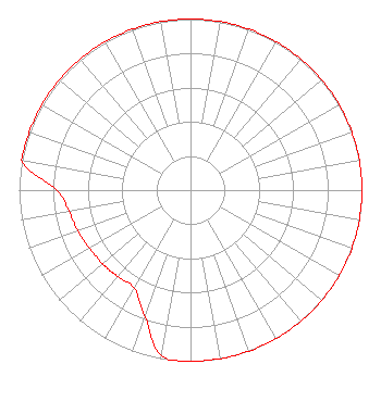 | ||||||||||||||||||
| Azimuth | Ratio | Azimuth | Ratio | Azimuth | Ratio | Azimuth | Ratio | ||||||||||||
| 0 | 1.000 | 10 | 1.000 | 20 | 1.000 | 30 | 1.000 | ||||||||||||
| 40 | 1.000 | 45 | 1.000 | 50 | 1.000 | 60 | 1.000 | ||||||||||||
| 70 | 1.000 | 80 | 1.000 | 90 | 1.000 | 100 | 1.000 | ||||||||||||
| 110 | 1.000 | 120 | 1.000 | 130 | 1.000 | 135 | 1.000 | ||||||||||||
| 140 | 1.000 | 150 | 1.000 | 160 | 1.000 | 170 | 1.000 | ||||||||||||
| 180 | 1.000 | 190 | 0.980 | 200 | 0.780 | 210 | 0.660 | ||||||||||||
| 220 | 0.660 | 225 | 0.665 | 230 | 0.670 | 240 | 0.680 | ||||||||||||
| 250 | 0.700 | 260 | 0.720 | 270 | 0.780 | 280 | 1.000 | ||||||||||||
| 290 | 1.000 | 300 | 1.000 | 310 | 1.000 | 315 | 1.000 | ||||||||||||
| 320 | 1.000 | 330 | 1.000 | 340 | 1.000 | 350 | 1.000 | ||||||||||||
Structure Registration Number 1007572 Structure Type: TOWER Registered To: BAKER, VERNON H:BAKER, VIRGINIA L DBA = WCXN AM WPAR FM Structure Address: Radio Rd Claremont, NC County Name: Catawba County ASR Issued: 02/24/1997 Date Built: 01/01/1986 Site Elevation: 286.6 m (940 ft.) Structure Height: 90 m (295 ft.) Height Overall: 91 m (299 ft.) Overall Height AMSL: 377.6 m (1239 ft.) FAA Determination: 02/14/1984 FAA Study #: 84-ASO-362-OE Paint & Light FAA Chapters: 1, 3, 11, 21 RED LIGHTS/PAINT 35-43-34.0 N 81-08-51.0 W (NAD 83) 35-43-33.5 N 81-08-51.7 W (Converted to NAD 27) |
Post Office Box 889 Blacksburg, VA 24063 | Date: 10/24/2001 Application Certifier POSITIVE ALTERNATIVE RADIO, INC. P.o. Box 889 Blacksburg, VA 24063-0889 Applicant CARY S. TEPPER, ESQ. Booth, Freret, Imlay & Tepper, Pc ELMER L. STEINGASS 2324 N. Cleve-mass Road Box 807 Bath, OH 44210-0807 CONSULTING ENGINEER | |||||||||||||||||