
FCCInfo.com
A Service of Cavell, Mertz & Associates, Inc.
(855) FCC-INFO
|
|
W280EV from 01/03/2014 |
|
|
||||||||||||||||
|
|
W280EV Channel: 280D 103.9 MHz Sarasota, Florida Service: FX - A translator or application for a translator. Facility ID: 140125 Fac. Service: FX Programming Delivery Method: Unspecified Status: License Application Accepted: 05/08/2017 Application Granted: 05/11/2017 File Number: BLFT-20170508ABE License Expires: 00/00/0000 Prefix Type: This is a license for a translator Application Type: License To Cover FCC Website Links: LMS Facility Details This Application CDBS Application Other W280EV Applications Other W280EV Applications in CDBS Including Superseded Applications Mailing Address Correspondence for W280EV Correspondence related to application BLFT-20170508ABE Service Contour - Open Street Map or USGS Map (60 dBu) Service Contour - KML / Google Earth (60 dBu) Class: D, A Noncommercial educational operating with no more than 10W Site Location: 27-20-09.4 N 82-28-18.8 W (NAD 83) Site Location: 27-20-08.2 N 82-28-19.5 W (Converted to NAD 27) Effective Radiated Power: 0 kW Horiz. ; 0.25 kW Vert. Transmitter Output Power: 0.15 kW Antenna Center HAAT: 0 m Antenna Center AMSL: 0 m Horiz.; 100 m Vert. Antenna Center HAG: 0 m Horiz.; 91 m Vert. Site Elevation: 9 m. (30 ft.) Height Overall*: 108 m (354 ft.) (* As Filed In This Application, may differ from ASR Data, Below.) Directional Antenna Antenna Make/Model: None Antenna ID: 61047 Polarization:
| ||||||||||||||||||
| Antenna Data for Antenna Id: 61047 W280EV FX File: BLFT-20170508ABE None - Service: FX Pattern and Field Values Include a 250° Clockwise Rotation | 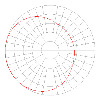 | ||||||||||||||||||
| Azimuth | Ratio | Azimuth | Ratio | Azimuth | Ratio | Azimuth | Ratio | ||||||||||||
| 0 | 0.679 | 10 | 0.630 | 20 | 0.592 | 30 | 0.566 | ||||||||||||
| 40 | 0.549 | 50 | 0.540 | 60 | 0.535 | 70 | 0.534 | ||||||||||||
| 80 | 0.535 | 90 | 0.540 | 100 | 0.549 | 110 | 0.566 | ||||||||||||
| 120 | 0.592 | 130 | 0.630 | 140 | 0.679 | 150 | 0.735 | ||||||||||||
| 160 | 0.792 | 170 | 0.845 | 180 | 0.892 | 190 | 0.929 | ||||||||||||
| 200 | 0.956 | 210 | 0.975 | 220 | 0.987 | 230 | 0.995 | ||||||||||||
| 240 | 0.999 | 250 | 1.000 | 260 | 0.999 | 270 | 0.995 | ||||||||||||
| 280 | 0.987 | 290 | 0.975 | 300 | 0.956 | 310 | 0.929 | ||||||||||||
| 320 | 0.892 | 330 | 0.845 | 340 | 0.792 | 350 | 0.735 | ||||||||||||
Structure Registration Number 1206413 Structure Type: TOWER Registered To: Pinnacle Towers LLC Structure Address: Shady Lane Sarasota, FL County Name: Sarasota County ASR Issued: 05/06/2016 Date Built: 03/02/1999 Site Elevation: 9.4 m (31 ft.) Structure Height: 103.6 m (340 ft.) Height Overall: 108.2 m (355 ft.) Overall Height AMSL: 117.6 m (386 ft.) FAA Determination: 03/15/2012 FAA Study #: 2012-ASO-1262-OE FAA Circular #: 70/7460-1K Paint & Light FAA Chapters: 4, 8, 12 PRIOR STUDY 2008-ASO-6858-OE 27-20-09.4 N 82-28-18.8 W (NAD 83) 27-20-08.2 N 82-28-19.5 W (Converted to NAD 27) |
7136 S. Yale Avenue Suite 501 Tulsa, OK 74136 Phone: 918-664-4581 | Date: 05/08/2017 Application Certifier CITICASTERS LICENSES, INC. 7136 S. Yale Avenue Suite 501 Tulsa, OK 74136-2623 Applicant RANDALL L. MULLINAX 2859 Cascade Dr. Gainesville, GA 30504 REGIONAL ENGINEER TROY G. LANGHAM Iheartmedia, Inc. 2625 S. Memorial Drive Suite A Tulsa, OK 74129-2623 | |||||||||||||||||