
FCCInfo.com
A Service of Cavell, Mertz & Associates, Inc.
(855) FCC-INFO
|
|
|
|
|
||||||||||||||||
|
|
W278BQ Channel: 278D 103.5 MHz Manitowoc, Wisconsin Service: FX - A translator or application for a translator. Facility ID: 155590 Fac. Service: FX Programming Delivery Method: Unspecified Status: License Application Accepted: 10/28/2016 Application Granted: 03/10/2017 File Number: BLFT-20161028AAF License Expires: 00/00/0000 Prefix Type: This is a license for a translator Application Type: Amendment FCC Website Links: LMS Facility Details This Application CDBS Application Other W278BQ Applications Other W278BQ Applications in CDBS Including Superseded Applications Mailing Address Correspondence for W278BQ Correspondence related to application BLFT-20161028AAF Service Contour - Open Street Map or USGS Map (60 dBu) Service Contour - KML / Google Earth (60 dBu) Class: D, A Noncommercial educational operating with no more than 10W Site Location: 44-07-31.0 N 87-37-41.3 W (NAD 83) Site Location: 44-07-31.0 N 87-37-41.0 W (Converted to NAD 27) Effective Radiated Power: 0.038 kW Transmitter Output Power: 0.061 kW Antenna Center HAAT: 0 m Antenna Center AMSL: 259 m (850 ft.) Antenna Center HAG: 76 m (249 ft.) Site Elevation: 183 m. (600 ft.) Height Overall*: 152 m (499 ft.) (* As Filed In This Application, may differ from ASR Data, Below.) Directional Antenna Antenna Make/Model: None Antenna ID: 126018 Polarization:
| ||||||||||||||||||
| Antenna Data for Antenna Id: 126018 W278BQ FX File: BLFT-20161028AAF None - Service: FX | 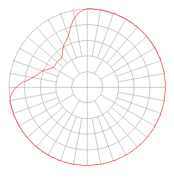 | ||||||||||||||||||
| Azimuth | Ratio | Azimuth | Ratio | Azimuth | Ratio | Azimuth | Ratio | ||||||||||||
| 0 | 1.000 | 10 | 1.000 | 20 | 1.000 | 30 | 1.000 | ||||||||||||
| 40 | 1.000 | 50 | 1.000 | 60 | 1.000 | 70 | 1.000 | ||||||||||||
| 80 | 1.000 | 90 | 1.000 | 100 | 1.000 | 110 | 1.000 | ||||||||||||
| 120 | 1.000 | 130 | 1.000 | 140 | 1.000 | 150 | 1.000 | ||||||||||||
| 160 | 1.000 | 170 | 1.000 | 180 | 1.000 | 190 | 1.000 | ||||||||||||
| 200 | 1.000 | 210 | 1.000 | 220 | 1.000 | 230 | 1.000 | ||||||||||||
| 240 | 1.000 | 250 | 1.000 | 260 | 1.000 | 270 | 0.900 | ||||||||||||
| 280 | 0.700 | 290 | 0.600 | 300 | 0.500 | 310 | 0.500 | ||||||||||||
| 320 | 0.500 | 330 | 0.600 | 340 | 0.700 | 350 | 0.900 | ||||||||||||
Structure Registration Number 1034205 Structure Type: Registered To: Seehafer Broadcasting Corp WQTC WLTU Structure Address: 1915 Mirro Dr Manitowoc, WI County Name: Manitowoc County ASR Issued: 11/06/2015 Date Built: 01/17/1986 Site Elevation: 182.9 m (600 ft.) Structure Height: 151 m (495 ft.) Height Overall: 152 m (499 ft.) Overall Height AMSL: 334.9 m (1099 ft.) FAA Determination: 10/01/1984 FAA Study #: 83-AGL-1439-OE FAA Circular #: 70/7460-1F Paint & Light FAA Chapters: 3, 4, 5, 9 RED LIGHTS/PAINT 44-07-31.0 N 87-37-41.0 W (NAD 83) 44-07-31.0 N 87-37-40.7 W (Converted to NAD 27) |
Pardeeville, WI 53954 Phone: 608-697-7820 Individual | Date: 10/28/2016 Application Certifier DAVID R. MAGNUM N6837 Bobbi Road Pardeeville, WI 53954 Applicant ANDREW DISTERHAFT 737 Wright St Oshkosh, WI 54901 TECHNICAL CONSULTANT JOHN C. TRENT, ESQ. Putbrese Hunsaker & Trent, P.c. 200 South Church Street Woodstock, VA 22664 | |||||||||||||||||