
FCCInfo.com
A Service of Cavell, Mertz & Associates, Inc.
(855) FCC-INFO
|
|
K206EI from 02/16/2001 |
|
|
||||||||||||||||
|
|
K206EI Channel: 206D 89.1 MHz Williston, North Dakota Service: FX - A translator or application for a translator. Facility ID: 106488 Fac. Service: FX Programming Delivery Method: Unspecified Status: License Application Accepted: 01/25/2011 Application Granted: 02/08/2011 File Number: BLFT-20110125AAY License Expires: 00/00/0000 Prefix Type: This is a license for a translator Application Type: License To Cover FCC Website Links: LMS Facility Details This Application CDBS Application Other K206EI Applications Other K206EI Applications in CDBS Including Superseded Applications Mailing Address Correspondence for K206EI Correspondence related to application BLFT-20110125AAY Service Contour - Open Street Map or USGS Map (60 dBu) Service Contour - KML / Google Earth (60 dBu) Class: D, A Noncommercial educational operating with no more than 10W Site Location: 48-08-30.1 N 103-53-35.7 W (NAD 83) Site Location: 48-08-30.0 N 103-53-34.0 W (Converted to NAD 27) Effective Radiated Power: 0 kW Horiz. ; 0.092 kW Vert. Transmitter Output Power: 0.094 kW Antenna Center HAAT: 0 m Horiz.; 107.1 m Vert. Antenna Center AMSL: 0 m Horiz.; 764 m Vert. Antenna Center HAG: 0 m Horiz.; 64 m Vert. Site Elevation: 700 m. (2297 ft.) Height Overall*: 251 m (823 ft.) (* As Filed In This Application, may differ from ASR Data, Below.) Directional Antenna Antenna Make/Model: None Antenna ID: 101795 Polarization:
| ||||||||||||||||||
| Antenna Data for Antenna Id: 101795 K206EI FX File: BLFT-20110125AAY None - Service: FX Pattern and Field Values Include a 90° Clockwise Rotation | 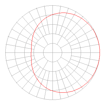 | ||||||||||||||||||
| Azimuth | Ratio | Azimuth | Ratio | Azimuth | Ratio | Azimuth | Ratio | ||||||||||||
| 0 | 0.801 | 10 | 0.848 | 20 | 0.889 | 30 | 0.923 | ||||||||||||
| 40 | 0.949 | 50 | 0.969 | 60 | 0.983 | 70 | 0.992 | ||||||||||||
| 80 | 0.998 | 90 | 1.000 | 100 | 0.998 | 110 | 0.993 | ||||||||||||
| 120 | 0.985 | 130 | 0.972 | 140 | 0.954 | 150 | 0.929 | ||||||||||||
| 160 | 0.896 | 170 | 0.857 | 180 | 0.811 | 190 | 0.760 | ||||||||||||
| 200 | 0.706 | 210 | 0.650 | 220 | 0.597 | 230 | 0.550 | ||||||||||||
| 240 | 0.510 | 250 | 0.478 | 260 | 0.458 | 270 | 0.451 | ||||||||||||
| 280 | 0.455 | 290 | 0.473 | 300 | 0.502 | 310 | 0.541 | ||||||||||||
| 320 | 0.588 | 330 | 0.640 | 340 | 0.695 | 350 | 0.750 | ||||||||||||
Structure Registration Number 1037969 Structure Type: TOWER Registered To: PRAIRIE PUBLIC BROADCASTING INC Structure Address: Om Us Hwy 2 17.7 Km W Williston, ND County Name: Williams County ASR Issued: 02/12/1998 Date Built: 11/16/1982 Site Elevation: 700.1 m (2297 ft.) Structure Height: 228.6 m (750 ft.) Height Overall: 251 m (823 ft.) Overall Height AMSL: 951.1 m (3120 ft.) FAA Determination: 03/26/1980 FAA Study #: 80-RM-06-OE FAA Circular #: Paint & Light FAA Chapters: 1, 3, 6, 15, 21 RED LIGHTS/PAINT 48-08-30.0 N 103-53-36.0 W (NAD 83) 48-08-29.9 N 103-53-34.3 W (Converted to NAD 27) |
Post Office Box 516 Mandan, ND 58554 Phone: 701-663-2345 Corporation | Date: 01/25/2011 Application Certifier REAL PRESENCE RADIO Post Office Box 13703 Grand Forks, ND 58208-1370 Applicant DENNIS J. KELLY Post Office Box 41177 Washington, DC 20018-0577 ATTORNEY/CONSULTANT DENNIS J. KELLY Dennis J. Kelly Post Office Box 41177 Washington, DC 20018-0577 | |||||||||||||||||